
Australians on the Western Front
- Thématique Tourisme de mémoire
- Mis à jour le 14/09/2017
- Identifiant 47350
Sélectionner le fond de carte

PLAN IGN

PHOTOS AERIENNES

CARTES IGN MULTI-ECHELLES

TOP 25 IGN

CARTES DES PENTES

PARCELLES CADASTRALES

CARTES OACI

CARTES 1950 IGN

CARTE DE L’ETAT-MAJOR (1820-1866)

Open Street Map
Afficher les points d'intérêt à proximité
Hébergements
Informations
Lieux d'intérêts
Producteurs
Restauration
Services et Commerces
Autre
Echelle
|
durée / niveau
Voiture
|
distance
293,4 km
type parcours
Aller Simple
|
|||||||||
|
Lieu de départ
Hors France
|
accessibilite
|
|||||||||
|
prestations payantes
Non
|
type(s) de sol
Bitume
|
|||||||||
|
Mots clés
somme, 14-18, guerre, australie, ypres
|
||||||||||
Photos & vidéos (5)
|
|
|
|
description
Australians on the Western Front
La description du circuit "The Australian Remembrance Trail in France and Belgium" provient du site :
http://www.ww1westernfront.gov.au/
Ce site décrit, en trois langues (anglais, français et néerlandais), les principaux lieux où ont combattu les Australiens pendant la Guerre 1914-1918.
Take the journey along the Australian Remembrance TrailBetween March 1916 and November 1918 more than 295,000 Australians served in the Australian Imperial Force (AIF) in France and Belgium.
Of these, some 132,000 became casualties and 46,000 lost their lives.
As the centenary of the First World War (1914–1918) approaches, more and more Australians are travelling to places along the old Western Front associated with the AIF.
They go to Pozières, where in a little over six weeks in 1916 the AIF suffered 23,000 battle casualties; or the fields of Belgian Flanders, where in October 1917 alone 6673 Australians died and a further 13,328 were wounded, missing or made prisoners of war.
Everywhere the memorials and cemeteries mark locations of loss to nation and family.
To help visitors appreciate the contribution of Australia to the Allied war effort along the Western Front, and the stories of those who served there, the Department of Veterans’ Affairs is developing the Australian Remembrance Trail.
The Trail highlights twelve sites, and other significant locations, from Passchendaele in Belgium down to the area of some of the AIF’s last actions in France around Péronne in 1918.
Faites un voyage dans le temps en suivant le Chemin de mémoire australienEntre mars 1916 et novembre 1918, plus de 295 000 Australiens servirent dans les rangs des forces armées impériales australiennes de l’AIF en France et en Belgique.
Parmi eux, on compte quelque 132 000 blessés et 46 000 morts.
À quelques années seulement du centenaire de la Première Guerre mondiale (1914-1918), un nombre croissant d’Australiens visitent des sites de l’ancien Front occidental associés à l’AIF.
Ils se rendent à Pozières où, en 1916, en un peu plus de six semaines, l’AIF déplora 23 000 morts ; ou sur les champs de la Flandre belge où, sur la seule période d’octobre 1917, pas moins de 6 673 Australiens perdirent la vie et 13 328 furent blessés, portés disparus ou faits prisonniers de guerre.
Partout, des monuments aux morts et des cimetières marquent l’emplacement des pertes que subirent la nation et les familles des combattants.
Pour aider les visiteurs à apprécier la contribution des Australiens à l’effort de guerre des Alliés sur le Front occidental et faire connaître l’histoire de ceux qui y participèrent, le ministère des Anciens combattants est en train d’aménager le Chemin de mémoire australien.
Ce circuit met en valeur douze sites ainsi que d’autres emplacements importants entre Passchendaele, en Belgique, et Péronne, où eurent lieu certaines des dernières interventions de l’AIF en France en 1918.
Reis mee langs de Australische HerdenkingstochtTussen maart 1916 en november 1918 dienden er meer dan 295.000 Australiërs in de Australische Imperiale Strijdkrachten (AIF) in Frankrijk en België.
Van hen raakte ongeveer 132.000 man gewond en liet 46.000 man het leven. Bijna een eeuw na de Eerste Wereldoorlog (1914-1918) reizen steeds meer Australiërs naar plaatsen aan het met de AIF geassocieerde oude Westelijk Front.
Ze gaan naar Pozières, waar de AIF in 1916 tijdens iets meer dan zes weken 23.000 manschappen verloor, of naar de velden van Belgisch Vlaanderen, waar in oktober 1917 alleen al 6673 Australiërs sneuvelden en waar 13.328 man gewond raakte, vermist werd of krijgsgevangene werd.
Overal markeren monumenten en begraafplaatsen locaties waar verlies werd geleden voor land en familie.
Om bezoekers een idee te geven van de bijdrage die Australiërs aan de Geallieerde oorlogsprestatie aan het Westelijk Front leverden, met de verhalen van hen die daar dienden, is het Department van Veterane Zaken bezig met het opzetten van de Australische Herdenkingstocht.
De Tocht gaat langs twaalf plaatsen en andere belangrijke locaties, van Passendale in België tot een van de laatste acties van de AIF in 1918 het gebied bij Péronne in Frankrijk.
copyright :http://www.dva.gov.au/footer/Pages/copyright.aspx
Circuit décrit par Pascal G. (77) en 2014.
V1.0 du 03-03-2016
Hébergements à proximité


infos parcours (41)
1
1-Site 1 - Ieper (Ypres)
1-Site 1 - Ieper (Ypres)
During the First World War the Belgian town of Ypres (Ieper) was devastated by shellfire and deserted by its inhabitants. Unforgettable images of this destruction were made by the Australian official photographer, Captain Frank Hurley, who also captured the lives of the Australian soldiers who inhabited these ruins during the Third Battle of Ypres (Passchendaele), which was fought to the east of the town between 31 July and 10 November 1917. The tragedy of wartime Ieper is told at the In Flanders Fields Museum in the Cloth Hall, a site on the Australian Remembrance Trail which includes stories of Australians associated with the town and its determined defence. La Halle aux Draps filmée lors de la 5ème étape Ypres Arenberg du Tour de France 2014source France Télévisions More about Ieper... http://www.ww1westernfront.gov.au/ieper/a-walk-around-ieper.php On this spot, your personal guide: The Cloth Hall, Ieper (Audio-cast, MP3, 3.5 MB)http://www.ww1westernfront.gov.au/audio/on-this-spot-cloth-hall-ieper-en.mp3
During the First World War the Belgian town of Ypres (Ieper) was devastated by shellfire and deserted by its inhabitants. Unforgettable images of this destruction were made by the Australian official photographer, Captain Frank Hurley, who also captured the lives of the Australian soldiers who inhabited these ruins during the Third Battle of Ypres (Passchendaele), which was fought to the east of the town between 31 July and 10 November 1917. The tragedy of wartime Ieper is told at the In Flanders Fields Museum in the Cloth Hall, a site on the Australian Remembrance Trail which includes stories of Australians associated with the town and its determined defence. La Halle aux Draps filmée lors de la 5ème étape Ypres Arenberg du Tour de France 2014source France Télévisions More about Ieper... http://www.ww1westernfront.gov.au/ieper/a-walk-around-ieper.php On this spot, your personal guide: The Cloth Hall, Ieper (Audio-cast, MP3, 3.5 MB)http://www.ww1westernfront.gov.au/audio/on-this-spot-cloth-hall-ieper-en.mp3
Informations complémentaires
kilomètre
0,00
latitude
50.8509
altitude
16
m
longitude
2.88534
2
2-The Menin Gate, Ieper
2-The Menin Gate, Ieper The best view of the Menin Gate is from the road – the N8, the Menin Road – leading into Ypres which passes through the memorial and on down the Meensestraat and into the Grote Markt. Standing facing the Gate on the morning of 24 July 1927 were thousands of people and draped over the inscription beneath the carving of the lion on top of the memorial were the flags of Britain, France and Belgium. On a wooden podium facing the crowd stood Field Marshal Lord Plumer of Messines, the so–called ‘Soldiers General’ and one of the best known British commanders during the British ‘Flanders Offensive’ east of Ypres in 1917. Australians had fought under Plumer’s overall direction at that time in the battles of Messines, Menin Road, Polygon Wood, Broodseinde, Poelcappelle and Passchendaele. It was Plumer’s role that July day in 1927 to unveil the Menin Gate, the first of the many British Empire memorials to the ‘missing’ along the old Western Front to be so dedicated between 1927 and 1938. The Menin Gate http://www.ww1westernfront.gov.au/ieper/menin-gate.php Plusieurs séquences filmées lors de la 5ème étape Ypres Arenberg du Tour de France 2014 :- la Porte de Menen- le mémorial canadien de Sint-Juliaan - la Nécropole Nationale Française de Saint Charles de Potyze source France Télévisions
Informations complémentaires
kilomètre
0,39
latitude
50.8519
altitude
25
m
longitude
2.89068
3
3-Essex Farm Cemetery Boezinge - Deutscher Soldatenfreidhof Vladslo
3-Essex Farm Cemetery Boezinge - Deutscher Soldatenfreidhof Vladslo During the fighting in the Salient the canal was a busy place spanned by many small makeshift bridges made from barrels or wood. Nightly ration parties, carrying parties and working parties made there way across the canal and out into the Salient to support those in the front line with food, ammunition and other essentials. At no time was the area free of enemy shelling – ‘then you will hear the rush and crump of a high explosive shell, feel the frame of your dugout tremble to its foundations’.The canal bank today has been turned into a pleasant, tree–lined walk with a park to the left and places for picnics. A track through the park leads to the remains of old concrete blockhouses which were used for many years after the war as housing by the returning inhabitants of Ypres. Towering over the canal bank back in the direction of Ypres is the 49th (West Yorkshire) Division Memorial dedicated in 1924. The panels on the memorial indicate the infantry battalions, artillery and other supporting arms of the division which served in many locations along the Western Front between 1915 and 1918 but spent a considerable amount time in the Ypres Salient. Essex Farm Cemetery http://www.ww1westernfront.gov.au/ieper/essex-farm.php Deutscher Soldatenfreidhof 1914-1918, Vladslohttp://www.ww1westernfront.gov.au/ieper/vladslo.php These desperate and costly actions – the Battle of the Yser – became known by the Germans as the ‘Slaughter of the Innocents’. To avoid a breakthrough along the Ijzer (Yser) River, the Belgians eventually opened the sea defences and flooded the area between Diksmuide and Nieuwpoort. The German advance into Belgium was finally halted at a spot indicated by a ‘Demarcation Stone’ at Diksmuide which King Albert of the Belgians unveiled on Easter Sunday 1922.In 1917, Australian tunnelling and artillery units helped defend the ‘Yser line’ on the North Sea coast at Nieuwpoort, the very end of the Western Front. A lone Australian artilleryman, Gunner Edwin Ernest Wheeler, who died in this area on 24 August 1917, lies buried in Ramscappelle Road Military Cemetery not far south of Nieuwpoort. Wheeler seems to have had no close family in Australia and on embarking from Melbourne for overseas service gave as his next of kin a stepsister living in Broxbourne, Hertfordshire, England.
Informations complémentaires
kilomètre
2,91
latitude
50.8714
altitude
14
m
longitude
2.87236
4
4-Site 2 - Tyne Cot Cemetery – Zonnebeke
4-Site 2 - Tyne Cot Cemetery – Zonnebeke Towering over the headstones in the Tyne Cot Cemetery, Belgium, is a Great Cross. Hidden beneath the cross’s stone pedestal are the remains of a German concrete bunker which, an inscription relates, was captured by the 3rd Australian Division on 4 October 1917. In this countryside was fought one of the most costly and horrific battles of the First World War – Passchendaele. In the mud of Passchendaele, in the month of October 1917 alone, the AIF lost 6673 dead. The Australian story at Passchendaele will be told nearby in the Memorial Museum Passchendaele in Zonnebeke, where a new gallery will open on 12 July 2013 as a site on the Australian Remembrance Trail. Le Cimetière Britannique de Tyne Cot filmé lors de la 5ème étape Ypres Arenberg du Tour de France 2014.source France Télévisions More about Tyne Cot Cemetery... http://www.ww1westernfront.gov.au/zonnebeke/visiting-tyne-cot.php On this spot, your personal guide: Tyne Cot blockhouse (The Great Cross) (Audio-cast, MP3, 3.88 MB)http://www.ww1westernfront.gov.au/audio/on-this-spot-tyne-cot-blockhouse-en.mp3
Informations complémentaires
kilomètre
12,09
latitude
50.8874
altitude
50
m
longitude
3.0007
5
5-Memorial Museum Passchendaele 1917 in Zonnebeke
5-Memorial Museum Passchendaele 1917 in Zonnebeke Zonnebeke and Passendale are two little villages, at a stone's throw from Ypres. During the British attack of 1917, there were 500.000 casulaties in 100 days for a gain territory of only 5 miles. Passchendaele became an international symbol of senseless military violence in its most cruel form. In the Memorial Museum the memory of the battle is kept alive through images and movies, a large collection of historical artefacts and several life-like-diorama's. Eye-cathcher is an underground dugout tunnel with communication- and dressing post, headquarters, workplaces and dormitories. A breathtaking experience of how the British had to live underground like moles... just because there was nothing left above. The museum is set up in the historical castle of Zonnebeke, on the road to Tyne Cot Cemetery. Tyne Cot is the biggest military cemetery of the Commonwealth with 12.000 graves and an impressive Missing Memorial. You can also pay a visit to a recently discovered underground dressing post, the German trenches in Bayernwald and strategic points like the Menin Road, 's Graventafel and Polygon Wood with a professional guide. The Memorial Museum Passchendaele 1917 is an ideal starting point for a visit to the old battlefields, an absolute must for tourists ands specialists. The Memorial Museum Passchendaele 1917 http://www.passchendaele.be/eng/homeEN.html
Informations complémentaires
kilomètre
14,13
latitude
50.8706
altitude
37
m
longitude
2.989
6
6-Fifth Australian Division Memorial, Zonnebeke
6-Fifth Australian Division Memorial, Zonnebeke The dedicatory plaque on the front face of the memorial has a few words in English and French. The English simply declares that the memorial is ‘To the Officers, Non–Commissioned Officers and Men’ who served in the division between 1916 and 1918. The French includes the rather more gracious phrase ‘A la Mémoire des ..’, ‘To the memory of …’. Beneath the dedication the Fifth Division listed 17 battle locations in France and Belgium, places it wished the visitor to realise epitomised for the soldiers of the division their struggle and sacrifice on the Western Front. Within a year of the end of World War I, Captain Alexander Ellis, late 29th Battalion, 8th Brigade, Fifth Australian Division, had produced his history of the division, the only Australian divisional history to come out of the ‘Great War’. Ellis proudly, and perhaps boldly, subtitled his work – ‘Being an Authoritative Account of the Division’s Doings in Egypt, France and Belgium’. Marshal Ferdinand Foch, the Frenchman who had been the supreme Allied commander of 1918, was prevailed upon to pen a foreword in French and Ellis ended his book with these stirring words:The Division’s Glorious Dead! … Of all those things of which the 5th Australian Division is proud, it is proudest of its Dead. Them it most reveres. The memory of them it cherishes above all things. May all Australian hearts be softened by their love, animated by their courage, ennobled and uplifted by their example until the end of time.Captain Alexander Ellis, The Story of the Fifth Australian Division, London, 1919, p.402 Fifth Australian Division Memorial http://www.ww1westernfront.gov.au/zonnebeke/fifth-australian-division-memorial.php
Informations complémentaires
kilomètre
15,65
latitude
50.857
altitude
52
m
longitude
2.99073
7
7-Menin Road
7-Menin Road On top of the Menin Gate memorial sits a stone lion gazing eastwards towards the old battleground of the ‘Ypres Salient’. Constant shelling by both sides turned the ‘Salient’ into a man–made wilderness of broken trees, craters, churned up earth and, when it rained, mud. By 1917, the fields had long disappeared and the villages were rubble where sometimes the shattered walls of a church survived to mark the spot. Through this devastation ran the Menin Road leading out from the ruins of Ieper south–eastwards towards the low ridge of the Ghuluvelt plateau.Historic photo: muddy, barren battlefield beyond Hooge, 1917The battlefield beyond Hooge over which the Australians advanced during the Battle of Menin Road on 20 September 1917. [AWM E02079] ... Enlarge historic photo: battlefieldPassing along the road to the front line soldiers ran the gauntlet of enemy shelling which far and near threw up spurts of earth. Closer to the line, the noise from the bursting of the shells merged into the clatter of machine gun and rifle fire. Beyond the road, strewn across the landscape, lay the wreckage of war... Demarcation stone at the Hellfire Corner roundabout, marking the furthest extent of the German advance towards Ypres during World War I. Menin Road Menin Road http://www.ww1westernfront.gov.au/zonnebeke/menin-road.php
Informations complémentaires
kilomètre
20,96
latitude
50.8486
altitude
34
m
longitude
2.91739
8
8-Hill 60, Zwarteleen
8-Hill 60, Zwarteleen Railway Dugouts Burial Ground might be an appropriate place for an Anzac Day service. In this cemetery, lying side by side in Plot IV, Row C, Graves 12 to 17, are six Australians of the First Australian Tunnelling Company. Another tunneller lies in Grave 10 of this row and another in Plot VI, Row G, Grave 33. What united them in death was the day they died – Anzac Day 1917. They died close by at Hill 60. What happened to Sapper Kenneth Hamilton that day was the fate of so many Australians on the Ypres battlefields of 1917. Hamilton was the ‘batman’, officer’s servant, to Captain A E Anderson, 1st Australian Tunnelling Company, and Anderson told the Australian Red Cross: ‘He Hamilton was killed in a dugout at Hill 60 by shellfire’. Lieutenant John Royle, also a tunneller, added the information that a shell from a German mortar had ‘crumpled’ the dugout killing three officers and six ‘batmen’. Hill 60, Zwarteleen http://www.ww1westernfront.gov.au/ploegsteert/zwarte-leen.php
Informations complémentaires
kilomètre
23,66
latitude
50.8237
altitude
58
m
longitude
2.92889
9
9-Island of Ireland Peace Park, Mesen (Messines)
9-Island of Ireland Peace Park, Mesen (Messines) This unusual memorial is dedicated to all Irishmen from whatever political persuasion or tradition who served and died in World War I, especially in the three divisions raised in Ireland of the BEF (British Expeditionary Force): the 36th (Ulster) Division, the 10th Division and the 16th Division.Round towers are to be found throughout Ireland, usually in connection with the sites of early Christian monasteries. There are also three pillars in the park on which are recorded the numbers of killed, wounded and missing in each division. Nine stone tablets, arranged along the pathway to the tower, feature quotations from Irish servicemen. Island of Ireland Peace Park http://www.ww1westernfront.gov.au/ploegsteert/messines.php
Informations complémentaires
kilomètre
33,96
latitude
50.7599
altitude
49
m
longitude
2.89559
10
10-Site 3 - Toronto Avenue Cemetery – Ploegsteert Wood
10-Site 3 - Toronto Avenue Cemetery – Ploegsteert Wood On the night of the 6–7 June 1917 gas shells rained on Ploegsteert Wood. The soldiers of Australia’s 3rd Division fumbled for their gas masks; dozens of pack horses and mules gasped for air; and men collapsed retching by the side of duckboard tracks. They struggled on and were soon in trenches ready to attack in the opening moments of the Battle of Messines. At the edge of the wood is Toronto Avenue Cemetery, an exclusively Australian burial ground, and the Battle of Messines will be brought alive at the Ploegsteert Interpretive Centre to be opened on 9 November 2013 as part of the Australian Remembrance Trail. More about Toronto Avenue Cemetery... http://www.ww1westernfront.gov.au/ploegsteert/visiting-toronto-avenue-cemetery.php Plugstreet 14-18 Experience, Ploegsteert, BelgiumPlugstreet 14-18 is a new interpretive centre telling the story of the soldiers and civilians who lived and fought in the Commines-Warneton area in the south of Belgium. The Centre is located in Ploegsteert Wood, which is also home to the Toronto Avenue Cemetery, the only all-Australian cemetery in Belgium where 78 Australians are buried. More than 800 guests attended the official opening on 9 November 2013. The Australian government contributed over $370,000 and more than 550 images to the Centre to tell Australia’s stories, from the 1st Australian Tunnelling Company and the Battle of Messines in 1917, to the Australian soldiers’ endurance of the bitter winter that followed.Visit the Plugstreet 14-18 Experience website.http://www.plugstreet1418.be/index.php?lg=en&;page=qui_sommes_nous On this spot, your personal guide: Toronto Avenue Cemetery, Ploegsteert Wood (Audio-cast, MP3, 4 MB)http://www.ww1westernfront.gov.au/audio/on-this-spot-toronto-avenue-cemetery-en.mp3
Informations complémentaires
kilomètre
36,36
latitude
50.7399
altitude
22
m
longitude
2.89635
11
62840 Fleurbaix
11-Site 4 - VC Corner Australian Cemetery and Memorial – Fromelles
11-Site 4 - VC Corner Australian Cemetery and Memorial – Fromelles On 11 November 1918 Charles Bean, Australia’s official war historian, stood on the battlefield of Fromelles: ‘We found the old no-man’s-land simply full of our dead’. These men died on 19–20 July 1916 assaulting the German lines, and their remains lie buried in VC Corner Australian Cemetery. In 1998, an Australian Memorial Park was dedicated on the old German front line and at its centre stands ‘Cobbers’, a statue showing an Australian soldier carrying a wounded mate from the battlefield. The story of this catastrophic event for Australia will be told in the Battle of Fromelles Museum to be opened in early 2014 as part of the Australian Remembrance Trail. More about Fromelles... http://www.ww1westernfront.gov.au/fromelles/visiting-fromelles.php Battle of Fromelles Museum, Fromelles, FranceThe Australian government contributed over $1 million to build a new museum beside the Fromelles Military Cemetery, France. The Battle of Fromelles was Australia’s first significant action on the Western Front in France. On 19-20 July 1916 more than 5500 men of the Fifth Australian Division became casualties. 400 of these men died of their wounds and are buried here at VC Corner, while a further 1,299 with no known grave are commemorated on a memorial wall beyond the cemetery. Following their discovery in 2008, the remains of 250 Australian and British soldiers have been recovered from unmarked mass graves nearby Pheasant Wood and reinterred with full military honours at Fromelles Military Cemetery. Visitors will learn more about these stories and Australia’s role in the area when the museum opens in July 2014. Visit La Communauté de Communes de Weppes website for updates on construction of the museum. On this spot, your personal guide: The Australian Memorial Park, Fromelles (Audio-cast, MP3, 3.59 MB)http://www.ww1westernfront.gov.au/audio/on-this-spot-australian-memorial-park-fromelles-en.mp3
Informations complémentaires
62840 Fleurbaix
kilomètre
53,68
latitude
50.6215
altitude
20
m
longitude
2.82898
12
62153 Ablain-Saint-Nazaire
12-Notre Dame de Lorette French Cemetery and Memorial
12-Notre Dame de Lorette French Cemetery and Memorial For France this is sacred ground containing the remains of more than 35,000 Frenchmen who died in action in the battles in this part of the old province of Artois in 1914 and 1915. At night this terrible loss is remembered by the flash of a 3,000 candlepower light, five times every minute, from the top of the lantern tower opposite the basilica. The graves by the standards of the British war cemeteries are austere – a simple cross with a small plaque carrying name, unit and date of death. Thousands of crosses stretch out in neat rows all around the basilica. Some carry the bleak message – ‘inconnu’ (‘unknown’). Four mass graves contain the unidentified remains of thousands more. It is sobering to realise that those buried here – approximately 35,000 soldiers – represent just 2.5 percent of the estimated 1,398,000 French war dead of World War I. After the memorial and cemetery had been established by the Association of Notre Dame de Lorette in the 1920s the Bishop of Arras wrote of this place:She must become the voice which weeps for her youth cut down in its flower, the voice which prays for the eternal rest of their souls, the voice which talks of hope to the widows, fiancées, parents … Extrait du documentaire Douce(s) France(s) – En Picardie et Nord-Pas-de-Calais (2013), une coproduction de ARTE G.E.I.E et de Gedeon Programmes avec RMC Découverte
Informations complémentaires
62153 Ablain-Saint-Nazaire
kilomètre
86,03
latitude
50.4029
altitude
181
m
longitude
2.70384
13
62580 Givenchy-en-Gohelle
13-Canadian National Vimy Memorial, Vimy Ridge
13-Canadian National Vimy Memorial, Vimy Ridge The magnificent view from the heights of Vimy Ridge is over the wide Douai plain of the Pas de Calais and Nord. Here, in 1914, was the great coal–mining region of northern France centred on the city of Lille. Clearly seen from the ridge is the famous ‘Double Crassier’, a huge twin–peaked slag heap, evidence of the extensive coal–mining past of the area. For much of the war the Germans occupied this industrial heartland of France and made use of its human and material resources for their war effort.Vimy Ridge is sacred ground to the Dominion of Canada. Here, at the height of the ridge on Hill 145, stands the Canadian National Vimy Memorial with its great twin pylons rising up into the sky. Around the memorial are twenty sculptured figures representing such ideas as peace, justice, mourning and grief. Like the Australian National Memorial at Villers–Bretonneux, Vimy carries the names of Canada’s ‘missing’ soldiers, those with ‘no known grave’ who died in France between 1914 and 1918. The Canadian memorial is situated in a 100–hectare park given by the people of France to Canada as a tribute to the Canadian soldiers who fought and died on the Western Front beside their French allies. Significantly, the park is part of the battlefield of the Battle of Vimy Ridge, fought between 9 and 12 April 1917. During those days the Canadians seized the ridge from the Germans and drove the enemy back down from the heights. It was a significant victory, for British and French forces had failed to drive back the Germans in this area despite strong offensives in 1915 west of these heights by the French and down in the plain by the British. Canadian National Vimy Memorial http://www.ww1westernfront.gov.au/fromelles/vimy-ridge.php Extrait du documentaire Douce(s) France(s) – En Picardie et Nord-Pas-de-Calais (2013), une coproduction de ARTE G.E.I.E et de Gedeon Programmes avec RMC Découverte
Informations complémentaires
62580 Givenchy-en-Gohelle
kilomètre
90,01
latitude
50.3794
altitude
145
m
longitude
2.76987
14
62580 Thélus
14-Zivy Crater Cemetery, Thélus
14-Zivy Crater Cemetery, Thélus In 1917, after the Battle of Vimy Ridge in May, a Canadian burial officer decided to use shell craters as mass graves and in a crater at Zivy, near the village of Thélus, he buried 53 bodies. Of these 50 were of identifiable Canadian soldiers. Initially, the cemetery was simply given the designation CB1; today it is known as Zivy Crater and it lies on the D49 between the villages of Neuville-St-Vaast and Thélus to the right of the road shortly before it crosses the A26 Autoroute. Zivy Crater Cemetery http://www.ww1westernfront.gov.au/fromelles/zivy-crater.php
Informations complémentaires
62580 Thélus
kilomètre
94,03
latitude
50.3549
altitude
108
m
longitude
2.77752
15
16-Noreuil Australian Cemetery
16-Noreuil Australian Cemetery In late March 1917, the German Army was withdrawing east and north – east of Bapaume back to its new fortress, the Hindenburg Line. This long stretch of trenches and barbed wire ran from Arras in a south–easterly direction towards Bullecourt, where it circled the village. After the occupation of Bapaume on 17 March 1917, elements of the Australian Imperial Force (AIF) pursued the enemy towards the Hindenburg Line over a triangle of French countryside enclosed roughly by the roads leading out of Bapaume to the north and east: the N17 and the N30. In this area are a series of villages where the Germans fought delaying, rearguard actions to allow as much work as possible to be completed on the Hindenburg Line. Placenames such as Lagnicourt, Vaulx–Vraucourt, Morchies, Louverval, Noreuil, Boursies and Hermies, where sharp actions took place costing Australian lives, passed into Australian military history but are now largely forgotten. Noreuil Australian Cemetery http://www.ww1westernfront.gov.au/bullecourt/noreuil.php
Informations complémentaires
35 r de la chapelle
62128 Noreuil
62128 Noreuil
kilomètre
120,97
latitude
50.1676
altitude
84
m
longitude
2.93351
16
62128 Bullecourt
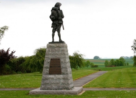
15-Site 5 - The Bullecourt Digger – Bullecourt
15-Site 5 - The Bullecourt Digger – Bullecourt Helping his mother to see what the battlefield of Bullecourt in May 1917 looked like, Private John Ware wrote: ‘if ever you saw a sheep camp in time of drought you will know how many sheep [die] in one night our men are lying about just the same’. Today at Bullecourt a statue, the ‘Digger’, stands in the Australian Memorial Park gazing out towards the enemy trenches which had cost so many Australian lives to capture. In the village, the story of the battles fought by Australians here in April and May 1917 is told in the Jean and Denise Letaille Museum. Voici une carte du secteur de Bullecourt en mai 1917 et un extrait d'une photo aérienne du même secteur prise en 1963.Source : The Department of Veterans' Affairs (DVA) australien et IGN More about the Bullecourt Digger... http://www.ww1westernfront.gov.au/bullecourt/visiting-bullecourt.php On this spot, your personal guide: The Bullecourt ‘Digger’ (Audio-cast, MP3, 3.66 MB)http://www.ww1westernfront.gov.au/audio/on-this-spot-the-bullecourt-digger-en.mp3
Informations complémentaires
62128 Bullecourt
kilomètre
121,39
latitude
50.1948
altitude
88
m
longitude
2.93822
17
17-Bapaume
17-Bapaume From the Butte de Warlencourt and Warlencourt British Cemetery it is but a short drive along the D929 to the town of Bapaume. To drive this road from the hill east out of Albert is to traverse the old Somme battlefield of 1916 over ground in which thousands upon thousands of soldiers lie buried, some in marked graves and many simply in the fields and forests from which their remains were never recovered. Villages whose names were once well known throughout the British Empire and Commonwealth lie a few kilometres off the road – Flers, Mametz, Thiepval, Martinpuich, Contalmaison. The names of two villages – Pozières and Bapaume – define the direction of the journey of the men of the Australian Imperial Force across this battleground between July 1916 and March 1917. Bapaume http://www.ww1westernfront.gov.au/bullecourt/bapaume.php
Informations complémentaires
1 r de douai
62450 Bapaume
62450 Bapaume
kilomètre
130,41
latitude
50.1046
altitude
125
m
longitude
2.85093
18
62450 Le Sars
18-Butte de Warlencourt
18-Butte de Warlencourt In the last days of the Battle of the Somme in November 1916, the British assaulted the Butte in the hope of wresting it from the Germans. They were not successful, and it remained in enemy hands throughout the winter, rising above shell holes, mud–filled trenches and desolate countryside.All winter the men of the Australian Imperial Force (AIF) gazed at the Butte from their trench lines forward of Flers and Le Sars. Regular patrols in no–man’s–land had examined German positions hereabouts, looking forward to spring, when the offensive would supposedly begin again. On the night of 23 February 1917, Australian patrols near the Butte reported that much coughing and talking could be heard from the German lines, as well as the firing of rifle grenades and flares. Later in the night there was more firing of machine–guns and sniper fire, but all was obscured by dense fog. On the next night, a patrol forward from the line held by the 9th Battalion (Queensland) crept towards the village of La Barque, visible to the north–east of the Butte. They found the enemy frontline trench deserted, finding nothing more dangerous there than a black cat! A message telling of the empty trench went to headquarters in code and simple French—‘, bon, très bon’. Butte de Warlencourt http://www.ww1westernfront.gov.au/bullecourt/warlencourt.php
Informations complémentaires
62450 Le Sars
kilomètre
136,26
latitude
50.0767
altitude
99
m
longitude
2.79241
19
24-Site 8 - The Windmill – Pozières
24-Site 8 - The Windmill – Pozières The Australian War Memorial owns a little piece of France – the Windmill site at Pozières. Australia’s official war historian, Charles Bean, suggested the purchase because ‘The Windmill site ... marks a ridge more densely sown with Australian sacrifice than any other place on earth’. Over seven weeks in 1916, at the Battle of the Somme, the Australian Imperial Force suffered 23,000 casualties, more than 6700 of whom died, in the countryside around the Windmill. On 11 November 1993 soil from the Windmill site was cast over the coffin of Australia’s Unknown Soldier during his funeral at the Australian War Memorial in Canberra. More about the Windmill – Pozières... http://www.ww1westernfront.gov.au/pozieres-windmill/visiting-pozieres-windmill.php On this spot, your personal guide: The Windmill, Pozières (Audio-cast, MP3, 3.94 MB)http://www.ww1westernfront.gov.au/audio/on-this-spot-the-windmill-pozieres-en.mp3 The sketch of the Pozières battlefield was drawn by Charles Bean for his book, Letters from France, published in London in 1917. Printed on the map is the description: Rough sketch showing some of the German defences of Pozières and the direction of the Australian attacks between July 22 and September 4, 1916. (From Pozières to Mouquet Farm is just over a mile.) With the German trenches shown encircling the village the map marks the various stages of the slow Australian advance against the Germans in this small area between 23 July 1916 – the capture of Pozières village – and the final failed attempt to seize Mouquet Farm on 3 September. Arrows indicate the direction of the attacks. From the south, the arrows of the ‘First Australian Attack’ drive north through the German front line at various points and into the ‘The Ruins of Pozières’ village. The arrows labelled ‘Second and Third Australian Attacks’ drive in a semicircle from east to north-west beyond Pozières against two lines of German trenches on the Pozières heights and the Pozières windmill. The arrows of ‘The Fourth and other Attacks’ again to the north-west past the ‘Quarry’ and against Mouquet Farm. The approximate location of the ‘Centre Way’ trench has been marked running nor’-nor’-east from the northern edge of Pozières, to the first German semi-circular trench line beyond. This crucial communications trench was dug, often at night, under heavy German bombardment. The Windmill itself is also marked on the road leading north-east out of Pozières towards Bapaume just beyond the second German trench line. [Charles Bean, Letters from France, Cassell and Company Ltd, London, 1917. Facing page 1.] Just where the ‘Centre Way’ trench ends we can see disturbed white chalk just beneath the surface of the fields showing the position of the old German lines. Indeed, most of the roads identified on Bean’s map still exist, including the road to Courcelette which branches off the D929 in the north-east.
Informations complémentaires
1000 rte de bapaume
80300 Pozières
80300 Pozières
kilomètre
141,64
latitude
50.0448
altitude
161
m
longitude
2.73627
20
25-The road to Flers
25-The road to Flers When the soldiers of the Australian Imperial Force came here to participate again in the battle of the Somme in late October 1916 they saw a landscape which had suffered from having been fought over by modern armies since the start of the battle on 1 July. ‘The idyllic landscape’, wrote Captain Alexander Ellis, the historian of the Australian Fifth Division, ‘became in a few short months the most loathsome and appalling terrain in the world’. Travelling these quiet roads today we can image the scene. Shells and machine gun bullets had stripped the trees of leaf and branch turning the woods into virtually impassable graveyards of twisted wood, shell holes and discarded equipment. Villages were rubble and the meadows a quagmire of craters and mud. Beside Longueval lies Delville Wood where, between 14 and 20 July 1916, the South African Brigade fought to seize the wood from its German defenders. The fighting was terrible and the South Africans, who had entered the action with 3,150 men were reduced to little more than 130 survivors at the end of it. The wood itself was not finally taken until 25 August. To Captain Ellis, as the Fifth Division came here in late October 1916, the wood was an abomination:Delville Wood in October 1916 was surely the most terrible spectacle that war had yet vouchsafed the world – Delville Wood, with its unburied corpses and its stinking trenches parapeted with dead Germans to protect those who yet lived. And perhaps some of the men who died in its foul recesses saw with a prophetic eye of death a future still unrevealed to us who are left. For a Tommy and a German, dying together in the same shell–hole, had smiled at each other before they breathed their last.
Informations complémentaires
5 rte de ginchy
80360 Longueval
80360 Longueval
kilomètre
144,09
latitude
50.0244
altitude
151
m
longitude
2.81272
21
80300 Ovillers-la-Boisselle
22-AIF Memorial, Mouquet Farm
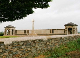
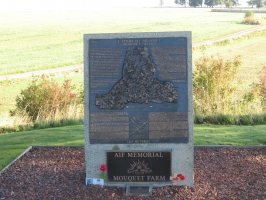
22-AIF Memorial, Mouquet There was heavy fighting here on 25 July 1916, two days after the opening of the Battle of Pozières, when the 4th and 8th Battalions AIF advanced northwards out of the village against German cross trenches. The 8th dug in about 40 metres beyond the cemetery and later the 6th Battalion came up and built a new defensive line from near the cemetery. They worked in the teeth of yet another ferocious German bombardment:Large numbers were wounded, especially NCOs, one company losing all its sergeants. Lieutenant Thompson was mortally wounded, but Captain Binns, after pacing out the line, walked up and down the parapet all day. ‘Buried, were you?’ he would remark cheerily to men who had been covered and dug out. ‘You were lucky you weren’t hit’! For four weeks, until relieved by the Canadians on 5 September 1916, the men of the First, Second and Fourth Australian Divisions took part in seven major attacks to dislodge the Germans from deep defences at the farm and surrounding trench systems. The purpose of the operations, the Battle of Mouquet Farm, was to drive a line behind the German strongholds at Thiepval, a kilometre or so away to the north, so forcing the enemy to give up these important positions. The enemy lines in front of Mouquet Farm ran from the north–east in a south–westerly direction a hundred or so metres beyond the first bend in the D73 past the cemetery. AIF Memorial, Mouquet Farm http://www.ww1westernfront.gov.au/pozieres-windmill/aif-memorial-mouquet-farm.php
Informations complémentaires
80300 Ovillers-la-Boisselle
kilomètre
144,43
latitude
50.0496
altitude
134
m
longitude
2.7079
22
21-Site 6 - Thiepval Memorial – Thiepval
21-Site 6 - Thiepval Memorial – Private George Lewis Grant, Australian Imperial Force, was killed during the Battle of the Somme at Pozières on 29 July 1916. His body lies in one of the most unusual cemeteries on the old Western Front, the Anglo-French Cemetery at Thiepval. Here, on two sides of the cemetery, are the graves of 300 French and 300 British Empire soldiers, symbolising the alliance of the French Republic and the nations of the British Empire in World War I. Over them towers the great Thiepval Memorial with more than 73,000 names of soldiers of the British Army who went ‘missing in action’ in the Somme region. More about Thiepval Memorial... http://www.ww1westernfront.gov.au/thiepval/visiting-thiepval-memorial.php On this spot, your personal guide: The Anglo-French Cemetery, Thiepval (Audio-cast, MP3, 3.78 MB)http://www.ww1westernfront.gov.au/audio/on-this-spot-anglo-french-cemetery-thiepval-en.mp3
Informations complémentaires
10 r de l'ancre
80300 Thiepval
80300 Thiepval
kilomètre
146,04
latitude
50.0513
altitude
145
m
longitude
2.68794
23
80300 Thiepval
20-Ulster Tower, Thiepval
20-Ulster Tower, Thiepval Australia was not the only part of the British Empire and Commonwealth to suffer grievous loss at the Battle of the Somme. On 12 July 1916, in the Protestant regions of the north of Ireland, there were no customary Orangeman’s Day parades with loud beating of the drums, lines of marching men and the skirling of flutes and bagpipes. Instead, at midday, traffic stopped in Belfast, and throughout the province of Ulster. People stood, heads bowed:In the middle of the roadway policemen on point duty stood rigidly to attention. The leaden seconds dragged away until the hands of the clocks had moved five minutes. And overhead the flags hung at half mast. The rain fell incessantlyClifford King, The Orange and the Green, London, 1967, p.7Among those silent crowds most would have known someone who just days earlier had been killed or wounded at Thiepval on 1 July 1916. On that day the men of the 36th Ulster Division advanced at 7.30 a.m. from the area of the woods to the left of the road, the D73, between Thiepval and the crossing of the River Ancre in the valley beyond. North of the Ancre, too, the Ulstermen were making for the German lines. At first glance the story of what happened to the Ulstermen that day is straightforward. They managed to press forward and seize a German strong point known as the ‘Schwaben Redoubt’ near the top of the hill to the right of the road where Connaught Cemetery now stands. This was one of the few successful actions on what became a day of disaster for the British Army. However, there they were soon trapped as other units to right and left, such as the Northumberland Fusiliers (at Thiepval), had been unable to move forward. As a result, the Germans were able to counter–attack with shell fire and machine gun fire from both flanks as well as from the front. The 36th Ulster Division fought in the Schwaben for seven hours until by mid–afternoon they had reached the limits of their endurance. Heavy German machinegun fire from the untaken village of Thiepval prevented their pioneer units digging communication trenches across the old no–man’s–land to their rear, and an ever–increasing number of men were being wounded or killed as German attacks and fire grew ever stronger. There was little hope of reinforcement as all 12 infantry battalions in the division had been committed to the morning attack. By nightfall what was left of the 36th Ulster division was back in the lines from which they had started in the morning. About one man in four, more then 5,000 men, was either killed, wounded or missing. Some units were especially badly affected. The 13th Battalion Royal Irish rifles (County Down Volunteers) had lost 595 men, well over half the battalion. One officer described the post–battle roll call:Not a few of the men cried and I cried. A hell of an hysterical exhibition it was. It is a very small company now. I took 115 other ranks and 4 officers (including myself) into action. I am the only officer and only 34 other ranks are with me now.Philip Orr The Road to the Somme, Belfast, 1987, p.191Where the Ulstermen fought and died there is a memorial – the Ulster Tower. It was constructed with funds raised totally by public subscription and unveiled on 19 November 1921, the first memorial of its kind to appear on the old Somme battlefield. Just inside the gate is a stone listing the names of Ulster recipients of the Victoria Cross during World War I, including Private Robert Quigg of Bushmills who went out into no–man’s–land looking for his officer, Sir Harry Macnaghten. Behind the Tower is a tearoom staffed by members of the Somme Association from Belfast. You can always get a good cup of Ulster tea at the Tower! Ulster Tower http://www.ww1westernfront.gov.au/thiepval/ulster-tower.php
Informations complémentaires
80300 Thiepval
kilomètre
146,91
latitude
50.0608
altitude
133
m
longitude
2.67968
24
19-Beaumont-Hamel Newfoundland Memorial, Beaumont-Hamel
19-Beaumont-Hamel Newfoundland Memorial, Beaumont-Hamel On 1 July 1916, the opening attacks of the 29th Division at the Battle of the Somme failed to seize the German lines on this part of the battlefield. Beyond the entrance to the Newfoundland Park is a large open area of countryside left just as it was on that day with all its trench lines and shell holes. From the elevated walkway beside the Caribou statue one can look out on this old battleground and try to imagine the noise and action of that morning. After the initial failure, in mid–morning the 29th Division ordered into the attack two of its reserve units – the 1st Battalion Essex Regiment and the Newfoundland Battalion. At that point no–one knew whether or not any of the 8 battalions which had taken part in the initial assault had actually reached the German lines. Tragedy now overtook the Newfoundlanders. From the reserve trenches to the old front line was a distance of about 275 metres. All the communication trenches to the front were already blocked with masses of wounded and other troops. The Newfoundlanders, however, had been told that their attack was urgent so they left their trenches, roughly behind where the Caribou Memorial now stands, and advanced to the right over open countryside towards the front line in the face of concentrated German machine gun fire. Even before they got to no–man’s–land they had to make their way through narrow gaps in British barbed wire and here they naturally bunched up. After the battle, the bodies of 69 Newfoundlanders were found in one of these gaps. The remnant of the battalion reached no–man’s–land and struggled on but none of them got far. To the right from the Caribou Memorial, out in the middle of the old battlefield, is a dead tree called the ‘Danger Tree’ around which many of the Newfoundlanders fell that day. Few of them made it beyond that point. Private F H Cameron, 1st Kings Own Scottish Borderers, saw them die:On came the Newfoundlanders, a great body of men, but the fire intensified and they were wiped out in front of my eyes. I cursed the generals for their useless slaughter, they seemed to have no idea what was going on. British historian Martin Middlebrook, estimates that 91 percent of those Newfoundlanders who attacked were either killed or wounded and concludes that ‘rarely can a battalion have been so completely smashed in such a short time’. Of the 778 men of the Newfoundland Regiment who went into action on 1 July 1916 only 68 answered the roll call at the end of the day. Beaumont-Hamel Newfoundland Memorial http://www.ww1westernfront.gov.au/thiepval/beaumont-hamel.php
Informations complémentaires
2 r d'auchonvillers
80300 Beaumont-Hamel
80300 Beaumont-Hamel
kilomètre
149,97
latitude
50.0839
altitude
104
m
longitude
2.6563
25
23-Site 7 - First Australian Division Memorial – Pozières
23-Site 7 - First Australian Division Memorial – Pozières During the last week of July 1916 shells fell in their thousands on Australian soldiers in a village they had captured from the Germans – Pozières. I had not the slightest idea where our lines or the enemy’s were, and the shells were coming at us from, it seemed, three directions, wrote Australian Lieutenant John Raws. Pozières was reduced to rubble and shattered earth, but here the men of the First Australian Division later built their memorial in France. They remembered the tenacity with which they had held their ground and the comrades who had perished in the horror of those bombardments. More about the First Australian Division Memorial... http://www.ww1westernfront.gov.au/pozieres-australian-memorial/visiting-pozieres.php On this spot, your personal guide: The Gibraltar blockhouse, Pozières (Audio-cast, MP3, 3.78 MB)http://www.ww1westernfront.gov.au/audio/on-this-spot-gibraltar-blockhouse-pozieres-en.mp3
Informations complémentaires
353 rte d'albert
80300 Pozières
80300 Pozières
kilomètre
153,50
latitude
50.0373
altitude
147
m
longitude
2.7224
26
80300 Mametz
26-Devonshire Cemetery, Mametz
26-Devonshire Cemetery, Mametz Inside the cemetery you are virtually in the old British front–line position as it was on the first day of the Battle of the Somme, 1 July 1916. Today, there are two lines of headstones, all joined closely together to indicate that this is a mass grave. With one or two exceptions the stones display one date – 1 July 1916 – and one unit: the Devons. One senses that here is a story, a tragedy among many tragedies, of that first day of the Battle of the Somme on which the British Army suffered 57,470 casualties. Of these, 21,392 were either killed in action, died of wounds or went ‘missing’ – the worst casualty figures ever in the British Army. From hereabouts, Captain Duncan Martin, 9th Battalion, Devonshire Regiment, had observed the location of a particular German machine gun. On 1 July, Martin’s men were to attack, not towards Mametz across the road, but at right angles towards the more distant village of Fricourt. Working from a plasticine model he had made of the area, Martin calculated that if this particular machine gun was not put out of action by British pre–attack bombardments then it would fire into the right flank of his men causing heavy casualties. Higher authorities assured him that the gun would be dealt with. When, on the morning of 1 July 1916, the Devons rose from their trenches, they were mown down by the machine gun whose crew had survived whatever bombardment had tried to put them out of action. Devonshire Cemetery http://www.ww1westernfront.gov.au/pozieres-australian-memorial/mametz.php
Informations complémentaires
80300 Mametz
kilomètre
159,27
latitude
49.9889
altitude
83
m
longitude
2.73586
27
28-Albert
28-Albert During 1916, and the early months of 1917, Albert was a town well known to the men of the AIF. Many of them marched through it or within sight of its most famous sight – the leaning statue of the Virgin with the infant Jesus in her arms at the top of the steeple of the church of Notre Dame de Brebières (Our Lady of the Ewes). The statue was hit by a German shell in 1915 and French engineers fixed it in place at right angles to the building. To the hundreds of thousands of soldiers on their way to the dangers of the front line the leaning Virgin seemed to symbolise much of the craziness and destructiveness of war and locally produced postcards of this famous phenomenon were sent to families around the world. Some said the war would end when the statue finally fell. It was knocked down in April 1918 by British artillery but the war went on until November 1918. The statue itself was never recovered and is thought to have been shipped to Germany for its metal value. During the Battle of the Somme, Albert was a place of temporary headquarters for the Australian divisions engaged in the heavy fighting on Pozieres ridge a few kilometres away. The straight Roman road from Albert to Bapaume in the east (now the D929) marked the intended line of advance of the British armies which assaulted the German lines along a front nearly 50 kilometres long on 1 July 1916. Albert had field ambulances which would often treat wounded men before they were taken to one of casualty clearing stations further to the west. Albert http://www.ww1westernfront.gov.au/pozieres-australian-memorial/albert.php
Informations complémentaires
1 r jean mermoz
80300 Albert
80300 Albert
kilomètre
165,77
latitude
49.9984
altitude
68
m
longitude
2.65419
28
27-The road to Pozières
27-The road to Pozières Running from Albert to the north–east is the D929 to Bapaume. This road bisects a region whose name has gone down in British history, let alone British military history – the Somme. At the right–hand side of the road, as it climbs a gradual hill just up from a large roundabout, is Bapaume Post Military Cemetery. It is worth pausing here to view the graves of the men of the Northumberland Fusiliers. There are 28 graves of men from this British regiment in Bapaume Post. All but one carry the date, 1 July 1916. In Plot 1, Row G, Grave 1 is Lieutenant Colonel William Lyle, age 40, commanding officer of the 23rd Battalion, Northumberland Fusiliers, one of the four battalions of the regiment called the ‘Tyneside Scottish’. These battalions were raised in the Tyneside industrial region of the north–east of England and associated themselves with a Scottish background. Further back in Plot 1 is Row A, just inside the entrance gate, and in Grave 34 lies Private John McCann, 25th Battalion, Northumberland Fusiliers. McCann’s battalion, along with three other battalions, was also raised in Tyneside but from individuals claiming Irish ancestry, hence they were known as the ‘Tyneside Irish’. Before dawn on 1 July 1916 the ‘Tyneside Irish’, the reserve unit of the 34th British Division, were in positions just a little further up the hill from Bapaume Post. On the other side of the hill the ‘Tyneside Scottish’ were already in the British front–line trenches waiting for zero hour. The road to Pozières http://www.ww1westernfront.gov.au/pozieres-australian-memorial/road-to-pozieres.php
Informations complémentaires
28 r henry potez
80300 Albert
80300 Albert
kilomètre
166,53
latitude
50.0118
altitude
98
m
longitude
2.67394
29
29-Dernancourt
29-Dernancourt Dernancourt’s association with Australia is evident in the street name ‘Rue d’Australie’ and the school hall, the ‘Pavillon Adelaide’. In the aftermath of World War I many regions of France where war damage had been extensive, the so–called ‘devastated regions’, were ‘adopted’ by places in the United Kingdom and the local people, who had become refugees, were given assistance to re–establish their lives and homes. Dernancourt was treated in a similar way by the people of South Australia.In countries like Britain, the United States and Australia it was recognised that France and Belgium, much of whose territory had been under German occupation and where the major battles of the war had been fought, had suffered in a manner quite unlike the other allied nations. Popular magazines, like the British The War Illustrated,ran articles and photographs throughout the war showing and describing the ‘devastated regions’:Many of the villages are mere heaps of loose brick and rubble. In some there are still a few roofless houses standing. But in some there is not even that, or anything at all to speak of human habitation. They have been simply obliterated; there are no houses, no churches or barns, no buildings of any kind; nothing but some mounds, strewn over with slates and shards, to show that this was once a home of men and women For most of the war, Dernancourt had been behind allied lines and had become a village well known to many Australian units during their stay on the Somme between July 1916 and March 1917.However, in March–April 1918, as the Germans pushed in their great offensive back across the Somme area, Dernancourt became the new front line. The village was destroyed by shellfire and its inhabitants forced to flee. In 1920 Dernancourt was adopted as ‘South Australia’s godchild’ and much practical help was given to the local people by South australians raising money and sending clothes. In 1921, a fete was held in the village to thank South Australia and the Rue Clemenceau was decorated with a triumphal arch bearing the words ‘Adelaide Merci’. Dernancourt http://www.ww1westernfront.gov.au/le-hamel/dernancourt.php
Informations complémentaires
1 r georges clemenceau
80300 Dernancourt
80300 Dernancourt
kilomètre
170,59
latitude
49.9735
altitude
45
m
longitude
2.63105
30
80800 Sailly-le-Sec
30-Third Australian Division Memorial, Sailly‑le‑Sec
30-Third Australian Division Memorial, Sailly‑le‑Sec Called ‘Operation Michael’, this massive German attack had quickly breached the British lines near St Quentin to the east. Their plan was to push rapidly westwards, capture the city of Amiens and then cut off the British armies in the north from their French allies in the south. The Germans had initially swept all before them and the British began to retreat across the famous 1916 battlegrounds of the Somme.To relieve the weary British, fresh divisions, including the Third Division, were rushed from the north to stem the German advance west of Albert. As the Australians reached the little Somme villages between 27 and 29 March they found French refugees everywhere. These people remembered the Australian battalions that had been billeted with them during the great British Somme offensive of July–November 1916 and in Heilly they welcomed them. Third Australian Division Memoria http://www.ww1westernfront.gov.au/le-hamel/sailly-le-sec.php
Informations complémentaires
80800 Sailly-le-Sec
kilomètre
176,18
latitude
49.936
altitude
107
m
longitude
2.5796
31
80800 Le Hamel
31-Site 10 - Australian Corps Memorial – Le Hamel
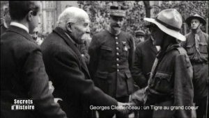
31-Site 10 - Australian Corps Memorial – Le Hamel The Battle of Hamel on 4 July 1918, it is usually claimed, took 93 minutes. According to one source in their official ‘War Diary’ the 44th Australian Infantry Battalion required only 85 minutes to take all their objectives. Starting at 3.10 am, then moving around Le Hamel village, the Western Australians advanced uphill, and by 4.35 had driven the Germans from a series of trenches and dugouts on top of the hill. There today stands the Australian Corps Memorial, with sweeping views across the valley of the Somme, a fitting place at which to remember the victories of the Australian Corps in France in 1918. The quick victory at Le Hamel, even though a minor one, gave Allied leaders then meeting in Paris a distinct morale boost. The 77–year–old French Prime Minister, Georges Clemenceau, who made it his habit every weekend to visit a French unit, was about to send the AIF a congratulatory message but decided, ‘No, I’ll go and see them myself’. So the following Sunday his weekend excursion took him to the Headquarters of the Australian 4th Division at Bussy–la–Daours near Corbie, not far from Le Hamel. Standing in the middle of a ring of Australian soldiers accompanied by Lieutenant General Sir John Monash, Australian Corps commander, Clemenceau spoke in English:When the Australian Army came to France, the French people expected a great deal of you … We knew that you would fight a real fight, but we did not know that from the beginning you would astonish the whole continent … I shall go back tomorrow and say to my countrymen: ‘I have seen the Australians. I have looked into their faces. I know that these men … will fight alongside us again until the cause for which we are all fighting is safe for us and our children. On this spot, your personal guide: Australian Corps Memorial, Le Hamel (Audio-cast, MP3, 3.44 MB)http://www.ww1westernfront.gov.au/audio/on-this-spot-australian-corps-memorial-lehamel-en.mp3 More about Australian Corps Memorial, Le Hamel... http://www.ww1westernfront.gov.au/le-hamel/visiting-le-hamel.php
Informations complémentaires
80800 Le Hamel
kilomètre
183,45
latitude
49.9
altitude
80
m
longitude
2.58047
32
80800 Fouilloy
32-Site 9 - Australian National Memorial – Villers-Bretonneux
32-Site 9 - Australian National Memorial – Villers-Bretonneux On 22 July 1938, Queen Elizabeth laid a bunch of poppies, given to her by a local schoolboy, at the unveiling of the Australian National Memorial at Villers-Bretonneux. Was she thinking of her own brother, Fergus Bowes-Lyon, ‘missing’ at the Battle of Loos in 1915? Around the walls of the Memorial were the names of some 11,000 Australians ‘missing’ in action in France. On the night of 24–25 April 1918, Australian soldiers recaptured Villers-Bretonneux from the Germans, a battle also remembered in the Franco-Australian museum at the Victoria school in the town. In the playground is a sign: ‘Never Forget Australia’. More about the Australian National Memorial at Villers-Bretonneux... http://www.ww1westernfront.gov.au/villers-bretonneux/visiting-villers-bretonneux.php On this spot, your personal guide: The Windmill, Pozières (Audio-cast, MP3, 3.94 MB)http://www.ww1westernfront.gov.au/audio/on-this-spot-the-windmill-pozieres-en.mp3
Informations complémentaires
80800 Fouilloy
kilomètre
185,36
latitude
49.8863
altitude
82
m
longitude
2.50804
33
34-Amiens Cathedral, Amiens
34-Amiens Cathedral, Amiens Defending Amiens 1918 – The sacrifice of your bloodOn 7 November 1920 in Notre Dame d’Amiens Cathedral, the Bishop of Amiens paid tribute to the soldiers of Australia for defending his city in its hour of peril:As Bishop of Amiens I owe you and your illustrious dead my heartfelt thanks because the land of my diocese has been your field of battle, and you have delivered it by the sacrifice of your blood. During the painful days of the invasion you made a rampart of your breasts, behind which you shielded and saved the last shreds of my territory … the children who in coming centuries will grow up in your homes and schools, will learn through your good deeds the lessons of patriotism. They will not be able to pronounce your name without speaking of the towns, villages, tablelands, ridges and valleys of the Somme. With those words the Bishop, in the presence of Andrew Fisher, Australia’s High Commissioner to London, Marshal Ferdinand Foch, Allied Supreme Commander in 1918, and a large local congregation unveiled a marble plaque affixed to a pillar in his cathedral. It was dedicated to the men of the AIF who had fought on the Somme between March and August 1918 and defended the city of Amiens from the Germans. As the inscription on the plaque asserts, the AIF had valiantly participated in the victorious defence of Amiens. Amiens Cathedral http://www.ww1westernfront.gov.au/villers-bretonneux/amiens-cathedral.php Extrait du documentaire Douce(s) France(s) – En Picardie et Nord-Pas-de-Calais (2013), une coproduction de ARTE G.E.I.E et de Gedeon Programmes avec RMC Découverte
Informations complémentaires
29 pl notre-dame
80000 Amiens
80000 Amiens
kilomètre
202,49
latitude
49.8949
altitude
32
m
longitude
2.30096
34
33-Adelaide Cemetery
33-Adelaide Cemetery Adelaide Cemetery is on the outskirts of Villers-Bretonneux, on the left of the N29 when you are travelling from Amiens. The cemetery is up an incline along a narrow grass path with trees to the right and emerging views of large fields and woods to the left. The size of the place, with more than 950 headstones, comes as a bit of a shock. Apart from the noise of an occasional train in the cutting beyond the cemetery, it is a peaceful place with, according to one battlefield guide, ‘a most delightful and varied array of plants’. On 24 April 1918 this area was a battlefield. Adelaide Cemetery http://www.ww1westernfront.gov.au/villers-bretonneux/adelaide-cemetery.php
Informations complémentaires
119 rte d'amiens
80800 Villers-Bretonneux
80800 Villers-Bretonneux
kilomètre
218,04
latitude
49.8711
altitude
79
m
longitude
2.49794
35
80131 Harbonnières
35-Heath Cemetery, Harbonnières
35-Heath Cemetery, Harbonnières Just across the road from where Lieutenant Arthur Kemp, 46th Battalion, seized the German position on 8 August 1918 is Heath Cemetery, Harbonnières. Harbonnières village is a couple of kilometres to the south. On this busy road Heath Cemetery is passed by by thousands of vehicles a year; but few stop. By comparison with the cemeteries of the old Somme 1916 battlefield, or Ieper in 1917, the experiences of the soldiers and airmen of the 1918 battlefield are little known in either Australia or Britain. Heath Cemetery contains 1,491 burials, 910 of them Australian from the battles and actions of August 1918 when the AIF pushed across this plain from Villers–Bretonneux in the west to the Somme River in front of Péronne to the east, a distance of about 50 kilometres. Dates on the Australian headstones serve to remind us of some little–remembered battles: Lihons on 9–11 August, Proyart on 12 August; and Albert on 23 August. Heath Cemetery http://www.ww1westernfront.gov.au/mont-st-quentin/heath-cemetery.php
Informations complémentaires
80131 Harbonnières
kilomètre
230,49
latitude
49.8729
altitude
94
m
longitude
2.67222
36
36-Péronne - L’Historial de la Grande Guerre
36-Péronne - L’Historial de la Grande Guerre The capture of Mont St Quentin and Péronne by the AIF came after long hard weeks of battle. The more open actions and advances of the last months of the war were not like the terrible battles of 1916 and 1917 but the fire from enemy machine guns and artillery was every bit as devastating. In 1918, the Australian Corps suffered 60,355 battle casualties of which 12,187 were killed in action or died of wounds. Moreover, voluntary enlistment in Australia was not providing the recruits necessary to keep the 60 Battalions of the AIF and other support units up to strength. As one observer, quoted by Charles Bean, dramatically wrote:Battalions are going into some of these fights 150 strong; 300 or 350 seems to be a big number in the fighting line these days. They are not as done as they were after Pozières, but they certainly are feeling that they have done more than their fair share of fighting … there is a feeling that ‘there wont be any Dominion Army left soon’, ‘There’ll be no AIF before long’. Péronne http://www.ww1westernfront.gov.au/mont-st-quentin/visiting-mont-st-quentin/peronne.php Historial de la Grande Guerre - Museum http://en.historial.org/
Informations complémentaires
6 pl d'estourmel
80200 Péronne
80200 Péronne
kilomètre
253,02
latitude
49.9291
altitude
50
m
longitude
2.93192
37
37-Site 11 - Second Australian Division Memorial – Mont St Quentin, and Péronne
37-Site 11 - Second Australian Division Memorial – Mont St Quentin, and Péronne Second Australian Division Memorial – Mont St Quentin, and Péronne, France Go to the Mont St Quentin siteBetween 31 August and 2 September 1918, Australia’s Second Division attacked and captured the German stronghold of Mont St Quentin, the key to the strategic town of Péronne on the Somme River. Tired and under strength, units such as the 21st Battalion skilfully drove the enemy from their well-established positions, and for his courage and leadership during the battle Sergeant Albert Lowerson, 21st Battalion, was awarded the Victoria Cross. It was a costly action: twenty-three men of the battalion lost their lives that day. Today the Second Australian Division’s Memorial stands at Mont St Quentin, the scene of one of the division’s greatest victories. More about the Second Australian Division Memorial... http://www.ww1westernfront.gov.au/mont-st-quentin/visiting-mont-st-quentin.php On this spot, your personal guide: Second Australian Division Memorial, Mont St Quentin (Audio-cast, MP3, 3.65 MB)http://www.ww1westernfront.gov.au/audio/on-this-spot-2nd-aus-div-memorial-mont-st-quentin-en.mp3
Informations complémentaires
123 av des australiens
80200 Péronne
80200 Péronne
kilomètre
255,59
latitude
49.9474
altitude
98
m
longitude
2.93256
38
02490 Pontruet
38-Site 12 - Fourth Australian Division Memorial – Bellenglise
38-Site 12 - Fourth Australian Division Memorial – Bellenglise Between 18 and 20 September 1918, the 48th Battalion, Fourth Division AIF, fought its last successful action on the Western Front. Advancing on the Hindenburg Outpost Line near Bellenglise, they suffered 65 casualties but captured 500 prisoners, ‘nearly one per man of the battalion’. Holding the line they got into a ‘bit of a fight’ for which Private James Woods was awarded the Victoria Cross. The Division, achieving all its objectives, took more than 4300 prisoners for 1260 casualties. Today the Fourth Division’s memorial in France stands on the heights above Bellenglise. It is little visited. More about Fourth Australian Division Memorial – Bellenglise... http://www.ww1westernfront.gov.au/bellenglise/visiting-bellenglise.php On this spot, your personal guide: Fourth Australian Division Memorial, Bellenglise (Audio-cast, MP3, 3.75 MB)http://www.ww1westernfront.gov.au/audio/on-this-spot-4th-aus-div-memorial-bellenglise-en.mp3
Informations complémentaires
02490 Pontruet
kilomètre
279,02
latitude
49.9305
altitude
126
m
longitude
3.22682
39
39-Calvaire Cemetery, Montbrehain
39-Calvaire Cemetery, Montbrehain At dawn, on 5 October 1918, in the countryside to the north and south of the road leading out of Ramicourt towards Montbrehain (the D713), the men of the AIF formed up once again for battle. South of the road was the 21st Battalion (Victoria), to the north was the 24th Battalion (Victoria), and between them was the 2nd Pioneer Battalion. These units were on the outer edge of the British Expeditionary Force’s advance through the Hindenburg Line – the German Army’s major defence line in France. Since 8 August 1918 the AIF had been in attack after attack as the Australians went from positions a couple of kilometres east of Villers-Bretonneux, across the uplands of the Somme, to participate in the capture of Péronne, then on eastwards to the storming of the Hindenburg Outpost Line near Bellenglise, and finally to the breaking of the Hindenburg Line itself. At this late stage of the war the 21st and 24th Battalions could muster no more than 240 riflemen in units where once 1,000 rifles had taken the field. Calvaire Cemetery http://www.ww1westernfront.gov.au/bellenglise/calvaire-cemetery-montbrehain.php
Informations complémentaires
13 r du cimetiere
02110 Montbrehain
02110 Montbrehain
kilomètre
292,22
latitude
49.9695
altitude
151
m
longitude
3.3447
40
60200 Compiègne
40-The Forest Clearing of the Armistice, Forêt de Compiègne
40-The Forest Clearing of the Armistice, Forêt de Compiègne Near midnight, with white flags flying and a bugler sounding his trumpet with regular four note blasts, the delegation approached the French line near Houdroy. From Houdroy, with a French trumpeter replacing the German, they drove on through devastated countryside to La Capelle to where a train was waiting to take them to a secret rendezvous in the great forest of Compiègne. There, in the dim morning light of 8 November 1918, the Germans could see that they had come to a clearing in the middle of which was a railway siding with two parallel tracks. Opposite their train was another – the headquarters train of the Allied Commander–in–Chief General Ferdinand Foch. With Foch was the leading British delegate on the Allied side, First Sea Lord Admiral Sir Rosslyn Wemyss. Wemyss was well known to Australians as the base commander at the island of Mudros, Greece, from which the AIF had set out for Gallipoli on 24 April 1915. Quite simply, armistice terms had been prepared between the British and French governments and it was not their intention to allow any but the most trifling discussion on details. The 34 clauses of the Armistice were now read out to the Germans who listened in horror. The fighting was to cease; within 28 days Germany was to be occupied west of the River Rhine with Allied enclaves to a depth of 30 kilometres on the east bank; all occupied territories were to be evacuated within 14 days; large numbers of locomotives and railway cars and wagons, lorries and other war equipment (artillery, aircraft, machine guns etc) was to be handed over; and all cash and gold from occupied banks instantly returned. The British naval blockade of Germany would continue. Hearing these conditions, one of the Germans wept openly. Germany was given 72 hours to accept or reject the terms but, meanwhile, the war would go on. Eventually, after referring the terms back to Berlin, the German delegates were authorised to sign. In the interim, the Kaiser had abdicated, going into exile in Holland, and a German Republic had been declared with a new socialist government in Berlin. At 5.30 am on 11 November 1918 both delegations signed the armistice, the Germans with tears in their eyes. The Forest Clearing of the Armistice http://www.ww1westernfront.gov.au/bellenglise/forest-clearing-of-the-armistice.php
Informations complémentaires
60200 Compiègne
kilomètre
292,57
latitude
49.4279
altitude
35
m
longitude
2.90657
41
41-Palace of Versailles
41-Palace of Versailles The Galerie des Glaces (Hall of Mirrors)Everyone knows that World War I lasted from ‘1914 to 1918’. Or did it? On a number of war memorials in Australia the dates of the war are shown as ‘1914–1919’. It was on 28 June 1919, when two representatives of the new German Republic signed the Treaty of Versailles with the victorious Allies, that peace finally and officially arrived.The town of Versailles is 20 kilometres west of Paris. Here is the Château de Versailles built by the ‘Roi Soleil’ (the ‘Sun King’), Louis XIV who ruled France between 1661 and 1715. The Château (usually referred to as the ‘Palace’ in English) reflected the might and power of the kings of France during that period. Once upon a time through the entrance gates, and set in the middle of the forecourt, the Place d’Armes, was an imposing statue of Louis XIV on horseback. Behind him, engraved on the buildings, is the phrase ‘A Toutes Les Gloires de la France’ – ‘To all the glories of France’. La photo aérienne ci-dessous a été réalisée par le Service Géographique de l'Armée (devenu l'IGN en 1940) et provient du site :http://centenaire.org/fr/tresors-darchives/cartographie/les-cartes-de-lignC'est la 20ème carte qu'il faut sélectionner." July 14th Parade; Signing of the Treaty of Versailles http://www.cnc-aff.fr/internet_cnc/Internet/ARemplir/parcours/EFG1914/pages_EN/B_659.html
Informations complémentaires
3 r colbert
78000 Versailles
78000 Versailles
kilomètre
327,91
latitude
48.8041
altitude
137
m
longitude
2.1236
Points d'interêt (10)
A
Ypres
Voir la fiche du point d'intéret »
Ypres - le Mont Kemmel - Dixmude
Lieux de mémoire
Fin octobre 1914, l’armée belge inonde les plaines de l’Yser en ouvrant les écluses afin de contrer toute avancée allemande sur la côte de la Mer du Nord. Ainsi prend fin « la course à la mer » au cours de laquelle se sera progressivement dessinée la ligne d’un front de part et d’autre duquel chaque camp allait entamer une longue guerre de position.
Passant à quelques kilomètres de la ville d’Ypres, le front forme un saillant dans les positions allemandes autour de la riche cité drapière.
Ypres verra ainsi se jouer à ses portes 5 sanglantes batailles et devenir cette « ville martyre » dont la défense deviendra la symbole de la résistance des Alliés face à l’envahisseur allemand.
Le front au 15 novembre 1914 en Belgique et dans la Région Nord - Pas-de-Calais
http://www.terres-de-guerre.fr/photo/54294d0326324bf10a000041/full
Point d'intérêt décrit par Pascal G.
V1.0 mars 2016
Informations complémentaires
Ypres
kilomètre
0,09
latitude
50.8513
altitude
18
m
longitude
2.88621
B
59249 Fromelles
Voir la fiche du point d'intéret »
Le Parc mémorial australien et Le Musée de la Bataille de Fromelles
Lieux de mémoire
Le 11 novembre 1918, Charles Bean, historien de guerre officiel de l’Australie, se tenait sur les champs de bataille de Fromelles : « Dans l’ancien no man’s land s’entassaient littéralement nos morts ». Ces hommes perdirent la vie les 19 et 20 juillet 1916 lors d’une attaque contre les lignes allemandes ; leurs dépouilles reposent au cimetière australien VC Corner. En 1998 fut inauguré le Parc mémorial australien sur l’ancienne ligne de front allemande. À son centre se dresse « Cobbers », une statue représentant un soldat australien portant un camarade blessé sur le champ de bataille. Le récit de cet événement tragique pour l’Australie est conté dans le Musée de la bataille de Fromelles, l’une des étapes du Chemin de mémoire australien, qui a ouvert ses portes en juillet 2014.
Le Musée de la Bataille de Fromelles
Situé juste à côté du cimetière militaire de Fromelles (Bois Faisan), le Musée de la Bataille de Fromelles raconte le déroulement de la pire journée de l’histoire militaire australienne ainsi que l’exhumation, près de 100 ans plus tard, des dépouilles de 250 soldats du Bois Faisan. Ce musée, qui a ouvert ses portes en juillet 2014, a bénéficié d’une contribution du Gouvernement australien de plus d’un million de dollars australiens.
Des renseignements concernant les visites sont disponibles sur le site Web
http://www.musee-bataille-fromelles.fr/?lang=fr
Point d'intérêt décrit par Pascal G.
V1.0 mars 2016
Informations complémentaires
59249 Fromelles
kilomètre
54,29
latitude
50.618
altitude
20
m
longitude
2.83542
C
62153 Ablain-Saint-Nazaire
Voir la fiche du point d'intéret »
La Nécropole de Notre-Dame-de-Lorette
Lieux de mémoire
La nécropole de Notre-Dame-de-Lorette est située sur le territoire de la commune d'Ablain-Saint-Nazaire. Elle a été créée sur le site de l'ancien oratoire du XVIIIème siècle, fondé par un peintre du village après son retour de pèlerinage à Lorette en Italie, sur une colline de 165 m où les batailles qui se déroulèrent d'octobre 1914 à octobre 1915 firent 100 000 morts et autant de blessés.
Point d'intérêt décrit par Pascal G.
V1.0 mars 2016
Point d'intérêt décrit par Pascal G.
V1.0 mars 2016
Informations complémentaires
62153 Ablain-Saint-Nazaire
kilomètre
85,10
latitude
50.4019
altitude
172
m
longitude
2.71817
D
62580 Givenchy-en-Gohelle
Voir la fiche du point d'intéret »
Lieu historique national du Canada de la Crête-de-Vimy - Monument à la Division Marocaine à Vimy
Lieux de mémoire
Lieu historique national du Canada de la Crête-de-Vimy
CENTRE D'INTERPRÉTATION DU MÉMORIAL - MINISTÈRE CANADIEN DES ANCIENS COMBATTANTS
Chemin des Canadiens
62580 VIMY
+33 (0)3 21 50 68 68
www.vac-acc.gc.ca
Erigées au point culminant de la crête, là où les troupes canadiennes ont remporté la bataille de Vimy en avril 1917, les deux tours blanches du mémorial dominent la plaine de Lens.
Hautes de 27 mètres et bâties avec 6 000 tonnes de pierre, elles sont l’œuvre de l’architecte et sculpteur canadien Walter Seymour Allward.
Elles symbolisent l’union par delà l’Océan du Canada représenté par la feuille d’érable et de la France avec la fleur de lys.Il aura fallu onze ans pour les construire et sculpter sur place les quelque vingt statues qui l’ornent. Les difficultés rencontrées ont été gigantesques en raison du sol bouleversé par quatre années de combats. 15 000 tonnes de béton armé ont dû être coulées pour les fondations.
Le Canada moderne est né dans les tranchées de Vimy.
La plus célèbre des statues, taillée dans un bloc de pierre de 30 tonnes, représente une femme affligée - la jeune nation canadienne - pleurant ses morts.
Sur le mur qui entoure le monument sont gravés les noms des 11 285 soldats tués en France lors de la Première Guerre mondiale et dont les corps n’ont jamais été retrouvés.
En leur honneur, autant de pins du Canada ont été plantés dans le parc proche du monument.
Au total, plus de 60 000 Canadiens ont perdu la vie durant la Grande Guerre et le Lieu historique national du Canada de la Crête-de-Vimy (le nom officiel de ce « Mémorial ») est dédié à leur mémoire.
Il s’étend sur 107 hectares, en grande partie reboisés.
Une partie des souterrains et des tranchées ont été conservés pour mieux comprendre l’âpreté des luttes qui ont permis aux divisions canadiennes de prendre la crête, le 10 avril 1917, et de dégager Arras, restée jusqu’alors sous le feu allemand.
Cette victoire - l’une des seules sur ce front avant 1918 – demeure une page majeure dans l’histoire de la nation canadienne.
Pour aller plus loin...
Vimy 1917
http://www.cheminsdememoire-nordpasdecalais.fr/comprendre-et-approfondir/batailles/vimy-1917.html
La bataille d’Arras (avril 1917)
http://www.cheminsdememoire-nordpasdecalais.fr/comprendre-et-approfondir/batailles/la-bataille-darras-avril-1917.html
Point d'intérêt décrit par Pascal G.
V1.0 mars 2016
Informations complémentaires
62580 Givenchy-en-Gohelle
kilomètre
90,04
latitude
50.3791
altitude
145
m
longitude
2.77023
E
Voir la fiche du point d'intéret »
La carrière Wellington à Arras
Lieux de mémoire
A la fin de l’année 1916, le secteur d’Arras est pressenti par les Etats Majors alliés pour être la base de départ d’une offensive de diversion. Cette action, combinée avec une attaque d’envergure dans le secteur français, devait attirer les troupes de réserve allemandes et faciliter la rupture des lignes ennemies entre Soissons et Reims.
A partir de ce moment, les Britanniques organisent l’attaque prévue pour le mois d’avril 1917. Le principal souci du haut commandement est de concentrer des troupes en grand nombre sans attirer l’attention de l’adversaire. Un vaste réseau souterrain va alors être réalisé, il permettra aux troupes anglaises de surgir à quelques dizaines de mètres devant les premières lignes ennemies sans avoir à subir le feu ennemi lors du passage dans le no man’s land. C’est aux tunneliers néo-zélandais que l’on doit en grande partie l’aménagement des vingt-deux kilomètres de cheminements souterrains, d’une carrière à l’autre. Ces lieux étaient agencés pour répondre aux besoins élémentaires des hommes : des cuisines, des douches, un hôpital, des latrines ont été réalisées. Ces souterrains ont pu accueillir plus de 24000 hommes, soit l’équivalent de la population de la ville d’Arras à la veille du 1er conflit mondial.
Point d'intérêt décrit par Pascal G.
V1.0 mars 2016
Informations complémentaires
107 av fernand lobbedez
62000 Arras
62000 Arras
kilomètre
103,68
latitude
50.2796
altitude
86
m
longitude
2.78239
F
Voir la fiche du point d'intéret »
Monuments et cimetières de Pozières
Lieux de mémoire
Le village de Pozières situé sur les hauteurs était un point central de la défense allemande.
Situé sur une crête, il était traversé par un double réseau de tranchées constituant la 2ème ligne allemande et flanqué de 2 blockhaus-observatoires au nord et au sud, dominant tout le champ de bataille (côté Albert, “Gibraltar” - côté Bapaume, “le Moulin à Vent”).
Sa position stratégique en fait un solideverrou, que les troupes alliées devaient conquérirpour investir la Ferme du Mouquet, puis la colline de Thiepval, point de défense également solide de l’armée germanique.
Cet objectif de contournement fut en majeure partie confié aux troupes d’Australie, dont la plupart rentraient de Gallipoli (détroit des Dardannelles), où les troupes australiennes, avec les troupes néo-zélandaises, subirent un baptême du feu extrèmement violent.
Arrivés le 23 juillet 1916 et après s’être emparés de Pozières, les Australiens, épuisés par d’incessantes contre-attaques d’artillerie, furent relevés le 5 septembre par les Canadiens à la Ferme du Mouquet. Trois de leurs divisions étaient passées par le secteur de Pozières et avaient subi des pertes supérieures au tiers des effectifs engagés.
Quant au village, il avait totalement disparu.
Le nom de Pozières possède une telle renommée dans la mémoire australienne qu’il a été donné, après la guerre, à un petit village du Queensland (Australie).
Mais Pozières a également été marqué par la première participation au combat des chars, le 15 septembre 1916,.
Des 49 tanks britanniques Mark I qui se déployèrent sur une ligne Courcelette - bois de Leuze (près de Combles), 27 tanks au total atteignirent la ligne de front allemande, 19 leur premier objectif, 11 leur second et seulement 6 leur troisième.
Cette date marque le début d’une progression britannique plus équilibrée et un annonce un changement dans la tactique de combat avec cette nouvelle arme.
Point d'intérêt décrit par Pascal G.
V1.0 mars 2016
sources :
http://www.somme14-18.com/lieu-de-souvenir/monuments-cimetieres-pozieres
http://www.somme-tourisme.com/cdt80/somme_tourisme/decouvrez/les_sites_de_la_grande_guerre/pozieres
Informations complémentaires
353 rte d'albert
80300 Pozières
80300 Pozières
kilomètre
142,97
latitude
50.038
altitude
149
m
longitude
2.72187
G
80800 Fouilloy
Voir la fiche du point d'intéret »
Le mémorial national australien de Villers-Bretonneux
Lieux de mémoire
Dessiné par l’architecte Sir Edwin Lutyens et inauguré le 22 juillet 1938 par le roi George VI d’Angleterre et la reine Elizabeth, cet imposant monument est le dernier des grands mémoriaux de l’Empire britannique et du Commonwealth de la Première Guerre mondiale à être construit sur le front occidental.
Ce jour-là, la reine Élizabeth déposa un bouquet de coquelicots, qui lui avait été donné par un écolier de la région, devant le Mémorial national australien de Villers-Bretonneux lors de son inauguration.
Eut-elle une pensée pour son propre frère, Fergus Bowes-Lyon, « disparu » lors de la bataille de Loos en 1915 ?
Sur les murs du monument sont gravés les noms de quelque 11 000 soldats australiens « disparus » au combat en France.
Dans la nuit du 24 au 25 avril 1918, les soldats australiens reprirent Villers-Bretonneux des mains des Allemands, une bataille également commémorée dans le musée franco-australien situé dans l’école Victoria du village
Dans la cour de l’école se trouve un écriteau : « Do Not Forget Australia » (« Ne pas oublier l’Australie »).
Point d'intérêt décrit par Pascal G.
V1.0 mars 2016
sources :
http://www.ww1westernfront.gov.au/french/villers-bretonneux/what-happened-here.php
http://www.somme14-18.com/lieu-de-souvenir/memorial-national-australien-villers-bretonneux
http://www.somme-tourisme.com/cdt80/somme_tourisme/decouvrez/les_sites_de_la_grande_guerre/memorial_national_australien
Informations complémentaires
80800 Fouilloy
kilomètre
185,38
latitude
49.8868
altitude
90
m
longitude
2.5096
H
Voir la fiche du point d'intéret »
HISTORIAL DE LA GRANDE GUERRE - Musée de la Première Guerre Mondiale
Lieux de mémoire
Une histoire culturelle comparée
Le musée a été conçu pour être un musée d’histoire culturelle, ce qui se traduit par une scénographie plaçant au centre de la présentation les individus :
les soldats comme les civils, les prisonniers, les populations occupées, déplacées…
Cette approche anthropologique vise à montrer l’humanité en guerre, dans une guerre totale affectant la société dans son ensemble.
Le mode de présentation muséographique se veut comparatiste, en mettant en parallèle pour chaque thème traité les productions des trois principaux belligérants et celles de leurs alliés. Ce comparatisme constitue la grande originalité du musée qui, par ce biais, montre et explique comment les populations ont réagi face à une conflagration d'une dimension jusqu'alors inconnue, selon leurs origines, leur culture et leur façon particulière d’envisager la guerre. Car pour ces populations immergées dans le conflit, la guerre est inséparable des représentations qui donnent sens aux souffrances endurées.
C'est cette "culture de guerre" qui constitue le point commun entre tous les acteurs sociaux de 1914 à 1918 et qui est au centre du propos muséal. C'est à travers les collections réunies pour le musée et constituées d'objets originaux de toute sorte – de la pièce d'artisanat de tranchée à la banale boîte de bonbons ; de l'œuvre d'art à la pièce d'uniforme – que cette "culture de guerre" est présentée au visiteur.
Au-delà des années de guerre proprement dites, l’Historial de la Grande Guerre propose une réflexion sur les origines et les conséquences du premier conflit mondial. Matrice du XXème siècle, la Première guerre mondiale a des répercussions toujours actuelles, sur le plan géopolitique et socioculturel. L’Historial de la Grande Guerre incite donc à la réflexion sur la nature de la violence, mécanismes de celle-ci, et sur sa nature protéiforme. Présenter la guerre sous tous ses aspects, c’est permettre de commencer une réflexion sur la paix au regard des les épreuves passées et du monde actuel.
L’Historial de la Grande Guerre invite donc chaque visiteur à s’interroger sur la notion de « conflit », à réfléchir sur le monde passé, présent et à venir. La muséographie cherche à expliquer dans un premier temps, pour que la connaissance permette ensuite à l’émotion de s’exprimer. Ainsi, le musée montre la profonde influence aux résonances contemporaines d’une guerre, totale, industrielle et mondiale.
Point d'intérêt décrit par Pascal G.
V1.0 mars 2016
sources :
http://www.historial.org/
http://www.somme14-18.com/lieu-de-souvenir/peronne-historial-grande-guerre
http://www.somme-tourisme.com/cdt80/somme_tourisme/decouvrez/les_sites_de_la_grande_guerre/historial_de_la_grande_guerre
Informations complémentaires
20 pl andre audinot
80200 Péronne
80200 Péronne
kilomètre
253,04
latitude
49.9293
altitude
52
m
longitude
2.93189
I
60400 Noyon
Voir la fiche du point d'intéret »
14-18, l'Oise se souvient
Lieux de mémoire
Pour prolonger les célébrations isariennes du centenaire 14-18 qui auront lieu dans l'Oise, le Conseil général a produit avec les Archives départementales et Oise tourisme, une série de webdocumentaires. A travers des témoignages d'historiens et des images d'archives, la collectivité souhaite ainsi vous sensibiliser au devoir de mémoire.
source
https://www.youtube.com/playlist?list=PLBKuPRJaTBpKJO4ypmo6Wbxtz-6kBqZ-_
Point d'intérêt décrit par Pascal G.
V1.0 mars 2016
source
https://www.youtube.com/playlist?list=PLBKuPRJaTBpKJO4ypmo6Wbxtz-6kBqZ-_
Point d'intérêt décrit par Pascal G.
V1.0 mars 2016
Informations complémentaires
60400 Noyon
kilomètre
277,69
latitude
49.5896
altitude
73
m
longitude
3.04493
J
Voir la fiche du point d'intéret »
Chemins de mémoire dans le Nord et l'Est de la France
Lieux de mémoire
Ce point d'intérêt permet de recenser les chemins de mémoire de la Grande Guerre dans le Nord et dans l'Est de la France.
Ces chemins de mémoire sont décrits sur le site Espace Loisirs de l'IGN : https://ignrando.fr/fr/parcours/
Ils proviennent des comités régionaux ou départementaux pour les circuits principaux.
Ils sont complétés par des parcours locaux décrits par les offices de tourisme.
Ces chemins de mémoire sont décrits sur le site Espace Loisirs de l'IGN : https://ignrando.fr/fr/parcours/
Ils proviennent des comités régionaux ou départementaux pour les circuits principaux.
Ils sont complétés par des parcours locaux décrits par les offices de tourisme.
Informations complémentaires
3 BIS r charles seydoux
59360 Le Cateau-Cambrésis
59360 Le Cateau-Cambrésis
kilomètre
312,65
latitude
50.1059
altitude
94
m
longitude
3.54052
notes, commentaires & photos (2)
Elan cyclotouriste de Champs-sur-Marne et Guerre 14-18
le 08/03/2016 à 06:49
Les Amis du Musée Territoire 14-
le 08/03/2016 à 06:26

Note moyenne
Cartes associées
