
Le Moulin Baron Bretagne
- Thématique Balade
- Mis à jour le 28/07/2020
- Identifiant 1048987
Sélectionner le fond de carte

PLAN IGN

PHOTOS AERIENNES

CARTES IGN MULTI-ECHELLES

TOP 25 IGN

CARTES DES PENTES

PARCELLES CADASTRALES

CARTES OACI

CARTES 1950 IGN

CARTE DE L’ETAT-MAJOR (1820-1866)

Open Street Map
Afficher les points d'intérêt à proximité
Hébergements
Informations
Lieux d'intérêts
Producteurs
Restauration
Services et Commerces
Autre
Echelle
|
durée / niveau
Randonnée/tourisme équestre
|
distance
17,1 km
type parcours
Aller Simple
|
|||||||||
|
Lieu de départ
35480 Guipry-Messac
|
accessibilite
|
|||||||||
|
prestations payantes
Non
|
type(s) de sol
Bitume
Graviers Terre Rochers |
|||||||||
Photos & vidéos (1)
|
description
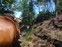
Nous partons en camion de Langon (35) pour aller jusqu'au Moulin de Baron, nous rentrons à cheval.
La partie ds le bois longeant l'étang est assez étroite
La partie ds le bois longeant l'étang est assez étroite
Hébergements à proximité

infos parcours (20)
1
LAP002
LAP002
Informations complémentaires
kilomètre
0,14
latitude
47.7832
altitude
19
m
longitude
-1.85428
2
LAP003
LAP003
Informations complémentaires
kilomètre
0,14
latitude
47.7832
altitude
19
m
longitude
-1.8543
3
LAP004
LAP004
Informations complémentaires
kilomètre
0,15
latitude
47.7832
altitude
18
m
longitude
-1.85435
4
LAP005
LAP005
Informations complémentaires
kilomètre
0,15
latitude
47.7832
altitude
18
m
longitude
-1.85437
5
LAP006
LAP006
Informations complémentaires
kilomètre
1,17
latitude
47.7839
altitude
16
m
longitude
-1.86063
6
LAP007
LAP007
Informations complémentaires
kilomètre
1,99
latitude
47.7804
altitude
28
m
longitude
-1.86457
7
LAP008
LAP008
Informations complémentaires
kilomètre
2,86
latitude
47.7759
altitude
80
m
longitude
-1.86432
8
LAP009
LAP009
Informations complémentaires
kilomètre
3,86
latitude
47.7677
altitude
95
m
longitude
-1.86614
9
LAP010
LAP010
Informations complémentaires
kilomètre
4,83
latitude
47.759
altitude
95
m
longitude
-1.86845
10
LAP011
LAP011
Informations complémentaires
kilomètre
5,30
latitude
47.755
altitude
59
m
longitude
-1.87006
11
LAP012
LAP012
Informations complémentaires
kilomètre
6,76
latitude
47.7507
altitude
39
m
longitude
-1.87177
12
LAP013
LAP013
Informations complémentaires
kilomètre
7,70
latitude
47.7468
altitude
75
m
longitude
-1.87768
13
LAP014
LAP014
Informations complémentaires
kilomètre
8,67
latitude
47.7446
altitude
87
m
longitude
-1.88896
14
LAP015
LAP015
Informations complémentaires
kilomètre
9,55
latitude
47.74
altitude
88
m
longitude
-1.89507
15
LAP016
LAP016
Informations complémentaires
kilomètre
10,50
latitude
47.7334
altitude
69
m
longitude
-1.89336
16
LAP017
LAP017
Informations complémentaires
kilomètre
11,45
latitude
47.7289
altitude
44
m
longitude
-1.89927
17
LAP018
LAP018
Informations complémentaires
kilomètre
12,38
latitude
47.7227
altitude
34
m
longitude
-1.90344
18
LAP019
LAP019
Informations complémentaires
kilomètre
13,33
latitude
47.7209
altitude
37
m
longitude
-1.89597
19
LAP020
LAP020
Informations complémentaires
kilomètre
14,30
latitude
47.7197
altitude
50
m
longitude
-1.88618
20
LAP021
LAP021
Informations complémentaires
kilomètre
15,09
latitude
47.7155
altitude
33
m
longitude
-1.88358
Murielle
Note moyenne
Cartes associées
