
Verlin-rû d'OC vers Saint Julien du Sault
- Thématique Balade
- Mis à jour le 10/10/2016
- Identifiant 143063
Sélectionner le fond de carte

PLAN IGN

PHOTOS AERIENNES

CARTES IGN MULTI-ECHELLES

TOP 25 IGN

CARTES DES PENTES

PARCELLES CADASTRALES

CARTES OACI

CARTES 1950 IGN

CARTE DE L’ETAT-MAJOR (1820-1866)

Open Street Map
Afficher les points d'intérêt à proximité
Hébergements
Informations
Lieux d'intérêts
Producteurs
Restauration
Services et Commerces
Autre
Echelle
|
durée / niveau
Rando pédestre
|
distance
10,2 km
type parcours
Boucle
|
|||||||||
|
Lieu de départ
7 pl de l'eglise
89330 Verlin |
accessibilite
|
|||||||||
|
prestations payantes
Non
|
type(s) de sol
Bitume
Graviers Terre |
|||||||||
Hébergements à proximité


notes, commentaires & photos (3)
Mireille
le 26/08/2019 à 12:39
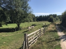
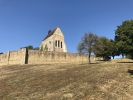
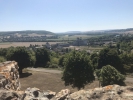
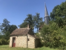
Très jolie randonnée qui pour une bonne partie en forêt (très appréciable par temps chaud). Je recommande d'allonger la boucle pour aller jusqu'à la chapelle de l'ex château de Vauguillin (superbe point de vue).
|
|
|
|

|
Mireille
le 26/08/2019 à 12:40
dispo pour partager ma trace (cf commentaire précédent) si vous le souhaitez;
Max
le 06/08/2024 à 12:03
Cela fait 77 ans que je connais Verlin. J'ai beaucoup voyagé dans ma vie en Europe, Afrique, Amérique du nord mais lorsque je suis heureux et que je ferme les yeux...au bout de quelques instants je descends en vélo des Marinières, je m'arrête chez Madame Féminier acheter un petit caramel à 5 centimes puis un petit bonjour au maréchal ferrand avant de longer le ruisseau vers St Julien. Après l'usine de lames de rasoirs il y a la petite côte pour rentrer dans St Julien mais c'est un bon entraînement pour monter à Vauguillain. Là, stop ! La vue est inouie, on pourrait presque voir Joigny à droite et Villeneuve sur Yonne à l'ouest. Et le tout sans aucun bruit.....le fleuve, de beau arbres et des gens charmants. Je reviendrai volontier mourir ici retrouver mes grands-parents dans ce joli cimetière
de Verlin.
Jean-François
Note moyenne
Cartes associées

Vous aimerez aussi
De Gare à Gare TER Villeneuve sur Yonne / St Julien Du Sault
Historique, patrimoine
18.8 km
| par Bernard |