
Jeu de Boules
- Thématique Randonnée
- Mis à jour le 23/03/2017
- Identifiant 163554
Sélectionner le fond de carte

PLAN IGN

PHOTOS AERIENNES

CARTES IGN MULTI-ECHELLES

TOP 25 IGN

CARTES DES PENTES

PARCELLES CADASTRALES

CARTES OACI

CARTES 1950 IGN

CARTE DE L’ETAT-MAJOR (1820-1866)

Open Street Map
Afficher les points d'intérêt à proximité
Hébergements
Informations
Lieux d'intérêts
Producteurs
Restauration
Services et Commerces
Autre
Echelle
|
durée / niveau
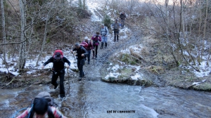
Rando pédestre
|
distance
15,8 km
type parcours
Boucle
|
|||||||||
|
Lieu de départ
38710 Prébois
|
accessibilite
|
|||||||||
|
prestations payantes
Non
|
type(s) de sol
Bitume
Terre Herbe |
|||||||||
Photos & vidéos (5)
|
|
|
|
|
Hébergements à proximité

infos parcours (1)
1
38710 Prébois
Interrogation
Cet endroit s'appelle "Jeu de Boules",c'est le point culminant de la rando, pourquoi ce nom ?
Informations complémentaires
38710 Prébois
kilomètre
5,54
latitude
44.7655
altitude
1068
m
longitude
5.74499
CHOCARD 38
Note moyenne
Cartes associées

Vous aimerez aussi
Traversée du Trièves à VTT (itinéraire des Grandes Traversées du Vercors)
Historique, patrimoine
126.3 km
| par Vercors |