
Caux Maritime du Tréport
- Thématique Mer, océan
- Mis à jour le 09/05/2017
- Identifiant 180490
Sélectionner le fond de carte

PLAN IGN

PHOTOS AERIENNES

CARTES IGN MULTI-ECHELLES

TOP 25 IGN

CARTES DES PENTES

PARCELLES CADASTRALES

CARTES OACI

CARTES 1950 IGN

CARTE DE L’ETAT-MAJOR (1820-1866)

Open Street Map
Afficher les points d'intérêt à proximité
Hébergements
Informations
Lieux d'intérêts
Producteurs
Restauration
Services et Commerces
Autre
Echelle
|
durée / niveau
Rando pédestre
|
distance
17,8 km
type parcours
Boucle
|
|||||||||
|
Lieu de départ
10 r amiral courbet
76470 Le Tréport |
accessibilite
|
|||||||||
|
prestations payantes
Non
|
type(s) de sol
Bitume
Terre Herbe |
|||||||||
Photos & vidéos (2)
|
|
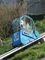
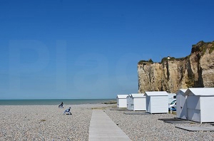
description
Départ au pied du Funiculaire du Tréport (voir pour parking voitures) et montée sur la falaise par ... les marches !!!. Puis une boucle d'environ 18 km en passant par Mesnil-Val et Criel-Plage.
Hébergements à proximité

notes, commentaires & photos (1)
Denis
le 06/11/2024 à 20:15

