
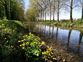
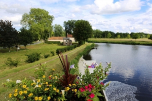
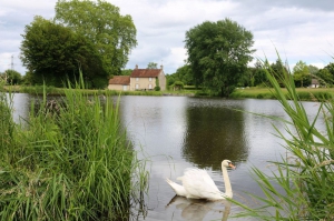
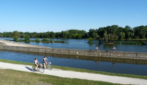
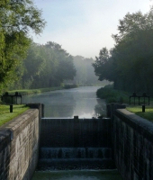
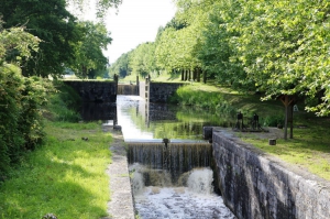
Canal d'Orléans de Chalette-sur-Loing à Orléans
- Mis à jour le 26/08/2022
- Identifiant 241579
Sélectionner le fond de carte

PLAN IGN

PHOTOS AERIENNES

CARTES IGN MULTI-ECHELLES

TOP 25 IGN

CARTES DES PENTES

PARCELLES CADASTRALES

CARTES OACI

CARTES 1950 IGN

CARTE DE L’ETAT-MAJOR (1820-1866)

Open Street Map
Afficher les points d'intérêt à proximité
Hébergements
Informations
Lieux d'intérêts
Producteurs
Restauration
Services et Commerces
Autre
Echelle
|
durée / niveau
Rando pédestre
|
distance
79,4 km
type parcours
|
|||||||||
|
Lieu de départ
94 Rue Robert Pichon
45120 CORQUILLEROY |
accessibilite
|
|||||||||
|
prestations payantes
Non
|
type(s) de sol
|
|||||||||
Photos & vidéos (8)
|
|
|
|
|
|
|
|
description
Canal d'Orléans de Chalette-sur-Loing à Orléans
Hébergements à proximité


infos parcours (209)
1
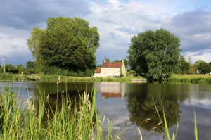
Point de vue sur l'étang du Gué du Cens
Informations complémentaires
La Folie
45260 VIEILLES-MAISONS-SUR-JOUDRY
45260 VIEILLES-MAISONS-SUR-JOUDRY
kilomètre
27,16
latitude
47.9019
altitude
121
m
longitude
2.44572
2
Banc
Informations complémentaires
6 Route de la Motte
45260 COUDROY
45260 COUDROY
kilomètre
24,55
latitude
47.9086
altitude
109
m
longitude
2.47055
3
Banc
Informations complémentaires
Le Petit Plessis
45260 COUDROY
45260 COUDROY
kilomètre
135,26
latitude
47.9136
altitude
106
m
longitude
2.48252
4
WC
Informations complémentaires
16 Quai du Canal
45450 DONNERY
45450 DONNERY
kilomètre
96,15
latitude
47.9154
altitude
104
m
longitude
2.10405
5
Banc
Informations complémentaires
1 Chemin du Halage
45450 FAY-AUX-LOGES
45450 FAY-AUX-LOGES
kilomètre
99,26
latitude
47.928
altitude
104
m
longitude
2.13777
6
Banc
Informations complémentaires
54 Route de Bellegarde
45530 SURY-AUX-BOIS
45530 SURY-AUX-BOIS
kilomètre
117,68
latitude
47.9633
altitude
124
m
longitude
2.35623
7
Banc
Informations complémentaires
63 Avenue Point À. Ponson du Terrail
45450 DONNERY
45450 DONNERY
kilomètre
97,03
latitude
47.9189
altitude
104
m
longitude
2.11195
8
Table de pique-nique
Informations complémentaires
89 Route de Bellegarde
45530 SURY-AUX-BOIS
45530 SURY-AUX-BOIS
kilomètre
118,24
latitude
47.9634
altitude
124
m
longitude
2.36728
9
Panneau Grignon au temps des mariniers
Informations complémentaires
155 Route de Grignon À Vieilles Maïs
45260 VIEILLES-MAISONS-SUR-JOUDRY
45260 VIEILLES-MAISONS-SUR-JOUDRY
kilomètre
132,56
latitude
47.8977
altitude
119
m
longitude
2.45489
10
Table de pique-nique
Informations complémentaires
10 Impasse de la Marine
45450 DONNERY
45450 DONNERY
kilomètre
96,16
latitude
47.9142
altitude
102
m
longitude
2.10256
11
45530 VITRY-AUX-LOGES
Table de pique-nique
Informations complémentaires
45530 VITRY-AUX-LOGES
kilomètre
109,88
latitude
47.938
altitude
117
m
longitude
2.26917
12
Banc
Informations complémentaires
76 Route des Caduels
45530 VITRY-AUX-LOGES
45530 VITRY-AUX-LOGES
kilomètre
110,67
latitude
47.9412
altitude
117
m
longitude
2.27851
13
Table de pique-nique
Informations complémentaires
78 Route de la Vallée
45530 COMBREUX
45530 COMBREUX
kilomètre
112,56
latitude
47.9554
altitude
122
m
longitude
2.29256
14
Banc
Informations complémentaires
Chemin du Halage
45450 FAY-AUX-LOGES
45450 FAY-AUX-LOGES
kilomètre
99,19
latitude
47.9276
altitude
104
m
longitude
2.13709
15
Poste de pêche PMR
Informations complémentaires
Le Fort
45260 CHAILLY-EN-GÂTINAIS
45260 CHAILLY-EN-GÂTINAIS
kilomètre
140,59
latitude
47.944
altitude
98
m
longitude
2.53493
16
Parking
Informations complémentaires
155 Route de Grignon À Vieilles Maïs
45260 VIEILLES-MAISONS-SUR-JOUDRY
45260 VIEILLES-MAISONS-SUR-JOUDRY
kilomètre
132,57
latitude
47.8977
altitude
116
m
longitude
2.4555
17
Poste de pêche PMR
Informations complémentaires
102 Route de Lorris
45260 PRESNOY
45260 PRESNOY
kilomètre
143,05
latitude
47.9538
altitude
96
m
longitude
2.5617
18
45260 COUDROY
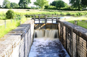
Écluse du Hateau
Informations complémentaires
45260 COUDROY
kilomètre
135,55
latitude
47.9153
altitude
107
m
longitude
2.48634
19
Table de pique-nique
Informations complémentaires
kilomètre
116,15
latitude
47.9639
altitude
127
m
longitude
2.33894
20
Poubelle
Informations complémentaires
4 Venelle du Quai au Vin
45450 FAY-AUX-LOGES
45450 FAY-AUX-LOGES
kilomètre
99,46
latitude
47.9315
altitude
104
m
longitude
2.14168
21
45260 VIEILLES-MAISONS-SUR-JOUDRY
Panneau Grignon au temps des mariniers
Informations complémentaires
45260 VIEILLES-MAISONS-SUR-JOUDRY
kilomètre
132,52
latitude
47.8979
altitude
119
m
longitude
2.45458
22
45530 VITRY-AUX-LOGES
Table de pique-nique
Informations complémentaires
45530 VITRY-AUX-LOGES
kilomètre
109,86
latitude
47.9379
altitude
117
m
longitude
2.26888
23
Banc
Informations complémentaires
kilomètre
131,69
latitude
47.9023
altitude
121
m
longitude
2.44556
24
Banc
Informations complémentaires
38 Route de Bellegarde
45530 SURY-AUX-BOIS
45530 SURY-AUX-BOIS
kilomètre
117,13
latitude
47.965
altitude
125
m
longitude
2.34934
25
Banc dégradé
Informations complémentaires
71-129 Route des Brulys
45700 CHEVILLON-SUR-HUILLARD
45700 CHEVILLON-SUR-HUILLARD
kilomètre
148,60
latitude
47.9719
altitude
91
m
longitude
2.62769
26
Poubelle
Informations complémentaires
kilomètre
106,54
latitude
47.9343
altitude
115
m
longitude
2.22735
27
45450 FAY-AUX-LOGES
Table de pique-nique
Informations complémentaires
45450 FAY-AUX-LOGES
kilomètre
102,24
latitude
47.9375
altitude
109
m
longitude
2.17442
28
Panneau d'information randonnée
Informations complémentaires
71 Route des Brulys
45700 CHEVILLON-SUR-HUILLARD
45700 CHEVILLON-SUR-HUILLARD
kilomètre
148,63
latitude
47.9717
altitude
91
m
longitude
2.62792
29
Panneau d'information randonnee
Informations complémentaires
Chemin du Halage
45450 FAY-AUX-LOGES
45450 FAY-AUX-LOGES
kilomètre
99,23
latitude
47.9278
altitude
104
m
longitude
2.13744
30
Point d'eau
Informations complémentaires
kilomètre
99,47
latitude
47.9294
altitude
105
m
longitude
2.1399
31
Poubelle
Informations complémentaires
2 Route de Châtenoy
45260 VIEILLES-MAISONS-SUR-JOUDRY
45260 VIEILLES-MAISONS-SUR-JOUDRY
kilomètre
132,19
latitude
47.8984
altitude
122
m
longitude
2.45348
32
Point de vue sur l'étang de la Noue Mazone
Informations complémentaires
Chemin de Blezine
45260 COUDROY
45260 COUDROY
kilomètre
130,08
latitude
47.9141
altitude
124
m
longitude
2.43749
33
Poubelle dégradée
Informations complémentaires
14 Chemin de Lonleuvre
45700 CHEVILLON-SUR-HUILLARD
45700 CHEVILLON-SUR-HUILLARD
kilomètre
145,13
latitude
47.9576
altitude
92
m
longitude
2.58868
34
Parking
Informations complémentaires
kilomètre
99,47
latitude
47.9295
altitude
105
m
longitude
2.13956
35
Poubelle
Informations complémentaires
Place des Marronniers
45450 FAY-AUX-LOGES
45450 FAY-AUX-LOGES
kilomètre
99,48
latitude
47.9296
altitude
104
m
longitude
2.13948
36
45530 VITRY-AUX-LOGES
Poubelle
Informations complémentaires
45530 VITRY-AUX-LOGES
kilomètre
109,86
latitude
47.9379
altitude
117
m
longitude
2.26885
37
Table de pique-nique
Informations complémentaires
kilomètre
148,61
latitude
47.9715
altitude
92
m
longitude
2.62776
38
Banc
Informations complémentaires
46 Rue Saint-Pierre
45530 COMBREUX
45530 COMBREUX
kilomètre
113,12
latitude
47.9565
altitude
125
m
longitude
2.29976
39
Poubelle
Informations complémentaires
Chemin du Halage
45450 FAY-AUX-LOGES
45450 FAY-AUX-LOGES
kilomètre
97,64
latitude
47.9224
altitude
103
m
longitude
2.12212
40
Table de pique-nique
Informations complémentaires
10 Impasse de la Marine
45450 DONNERY
45450 DONNERY
kilomètre
96,16
latitude
47.9142
altitude
102
m
longitude
2.10264
41
Banc
Informations complémentaires
kilomètre
99,48
latitude
47.9296
altitude
104
m
longitude
2.13948
42
anneau d'information du canal
Informations complémentaires
55 Route de Nestin
45450 FAY-AUX-LOGES
45450 FAY-AUX-LOGES
kilomètre
100,70
latitude
47.9369
altitude
106
m
longitude
2.15154
43
45260 CHAILLY-EN-GÂTINAIS
Ecluse de la Vallée
Informations complémentaires
45260 CHAILLY-EN-GÂTINAIS
kilomètre
137,08
latitude
47.9231
altitude
103
m
longitude
2.50043
44
Bar-Restaurant-Epicerie
Informations complémentaires
8 Place du Bourg
45260 COUDROY
45260 COUDROY
kilomètre
134,02
latitude
47.9078
altitude
110
m
longitude
2.46895
45
Banc
Informations complémentaires
kilomètre
147,60
latitude
47.966
altitude
91
m
longitude
2.6208
46
Parking
Informations complémentaires
2 D39
45260 CHAILLY-EN-GÂTINAIS
45260 CHAILLY-EN-GÂTINAIS
kilomètre
141,50
latitude
47.9485
altitude
97
m
longitude
2.54249
47
Banc
Informations complémentaires
1 Quai du Canal
45450 DONNERY
45450 DONNERY
kilomètre
96,22
latitude
47.9149
altitude
102
m
longitude
2.1035
48
45260 VIEILLES-MAISONS-SUR-JOUDRY
Panneau Grignon au temps des mariniers
Informations complémentaires
45260 VIEILLES-MAISONS-SUR-JOUDRY
kilomètre
132,50
latitude
47.898
altitude
119
m
longitude
2.45426
49
Ecluse de Marchais Clair
Informations complémentaires
kilomètre
144,88
latitude
47.9574
altitude
93
m
longitude
2.58761
50
Banc
Informations complémentaires
Chemin du Halage
45450 FAY-AUX-LOGES
45450 FAY-AUX-LOGES
kilomètre
97,63
latitude
47.9224
altitude
103
m
longitude
2.12218
51
Banc sans dossier
Informations complémentaires
170 Rue Sainte-Catherine
45700 PANNES
45700 PANNES
kilomètre
155,51
latitude
48.01
altitude
83
m
longitude
2.69122
52
Table de pique-nique
Informations complémentaires
kilomètre
133,37
latitude
47.904
altitude
113
m
longitude
2.46397
53
Table de pique-nique
Informations complémentaires
30 Route de la Chênetière
45530 VITRY-AUX-LOGES
45530 VITRY-AUX-LOGES
kilomètre
106,54
latitude
47.9342
altitude
114
m
longitude
2.22729
54
Poubelle
Informations complémentaires
10 Impasse de la Marine
45450 DONNERY
45450 DONNERY
kilomètre
96,16
latitude
47.9142
altitude
102
m
longitude
2.10258
55
Poubelle
Informations complémentaires
12 Route des Mariniers
45260 CHÂTENOY
45260 CHÂTENOY
kilomètre
127,40
latitude
47.9179
altitude
124
m
longitude
2.40992
56
Banc
Informations complémentaires
kilomètre
113,40
latitude
47.9573
altitude
124
m
longitude
2.30339
57
Table de pique-nique
Informations complémentaires
5 Rue du Port
45260 CHAILLY-EN-GÂTINAIS
45260 CHAILLY-EN-GÂTINAIS
kilomètre
141,61
latitude
47.9491
altitude
96
m
longitude
2.54368
58
Parking et accès au canal
Informations complémentaires
22 Rue Robert Pichon
45120 CORQUILLEROY
45120 CORQUILLEROY
kilomètre
158,08
latitude
48.0245
altitude
83
m
longitude
2.71749
59
Poubelle
Informations complémentaires
kilomètre
131,05
latitude
47.908
altitude
124
m
longitude
2.44497
60
Table de pique-nique
Informations complémentaires
65-71 Route de la Vallée
45530 COMBREUX
45530 COMBREUX
kilomètre
112,52
latitude
47.9559
altitude
125
m
longitude
2.29482
61
Banc
Informations complémentaires
290 Rue de l'Écluse
45700 PANNES
45700 PANNES
kilomètre
155,43
latitude
48.0091
altitude
86
m
longitude
2.68904
62
Poubelle
Informations complémentaires
78 Route de la Vallée
45530 COMBREUX
45530 COMBREUX
kilomètre
112,55
latitude
47.9559
altitude
124
m
longitude
2.29433
63
Banc
Informations complémentaires
kilomètre
92,44
latitude
47.8957
altitude
101
m
longitude
2.06283
64
Poubelle
Informations complémentaires
Chemin de la Fontaine Pierrée
45530 COMBREUX
45530 COMBREUX
kilomètre
113,75
latitude
47.9584
altitude
126
m
longitude
2.30777
65
Banc
Informations complémentaires
D38
45260 PRESNOY
45260 PRESNOY
kilomètre
142,76
latitude
47.9537
altitude
96
m
longitude
2.56027
66
Banc
Informations complémentaires
kilomètre
141,51
latitude
47.9498
altitude
96
m
longitude
2.5451
67
Banc
Informations complémentaires
Route Forestière de Courcy-aux-Loges
45530 SURY-AUX-BOIS
45530 SURY-AUX-BOIS
kilomètre
115,22
latitude
47.9634
altitude
127
m
longitude
2.32781
68
Panneau d'information du canal
Informations complémentaires
71 Route des Brulys
45700 CHEVILLON-SUR-HUILLARD
45700 CHEVILLON-SUR-HUILLARD
kilomètre
148,63
latitude
47.9716
altitude
91
m
longitude
2.62796
69
Banc
Informations complémentaires
10 Quai Aristide Briand
45530 VITRY-AUX-LOGES
45530 VITRY-AUX-LOGES
kilomètre
109,81
latitude
47.9377
altitude
116
m
longitude
2.26824
70
Poubelle
Informations complémentaires
kilomètre
133,37
latitude
47.904
altitude
113
m
longitude
2.46396
71
Banc
Informations complémentaires
4 Route de Combreux
45530 SURY-AUX-BOIS
45530 SURY-AUX-BOIS
kilomètre
116,43
latitude
47.9637
altitude
127
m
longitude
2.34048
72
Banc
Informations complémentaires
33 Route du Port
45260 CHÂTENOY
45260 CHÂTENOY
kilomètre
127,14
latitude
47.9204
altitude
125
m
longitude
2.40726
73
Banc
Informations complémentaires
kilomètre
112,49
latitude
47.9547
altitude
121
m
longitude
2.2917
74
Banc
Informations complémentaires
2155 Rue de Donnery
45430 MARDIÉ
45430 MARDIÉ
kilomètre
93,80
latitude
47.9017
altitude
102
m
longitude
2.0786
75
Banc
Informations complémentaires
40 Avenue Point À. Ponson du Terrail
45450 DONNERY
45450 DONNERY
kilomètre
96,41
latitude
47.917
altitude
104
m
longitude
2.108
76
Aire de jeux
Informations complémentaires
kilomètre
141,50
latitude
47.9488
altitude
96
m
longitude
2.54225
77
Table de pique-nique
Informations complémentaires
1576-1974 Rue de Genon
45450 MARDIÉ
45450 MARDIÉ
kilomètre
93,09
latitude
47.9002
altitude
101
m
longitude
2.07265
78
Banc
Informations complémentaires
1493 Rue de Donnery
45430 MARDIÉ
45430 MARDIÉ
kilomètre
92,78
latitude
47.8987
altitude
100
m
longitude
2.06925
79
Banc
Informations complémentaires
kilomètre
113,45
latitude
47.9578
altitude
126
m
longitude
2.30643
80
Banc
Informations complémentaires
Chemin du Halage
45450 FAY-AUX-LOGES
45450 FAY-AUX-LOGES
kilomètre
98,61
latitude
47.9251
altitude
104
m
longitude
2.13242
81
45530 VITRY-AUX-LOGES
Poubelle
Informations complémentaires
45530 VITRY-AUX-LOGES
kilomètre
104,42
latitude
47.9305
altitude
111
m
longitude
2.19763
82
Table de pique-nique
Informations complémentaires
kilomètre
147,60
latitude
47.9642
altitude
95
m
longitude
2.61987
83
Poubelle
Informations complémentaires
7 Route de Montargis
45260 CHAILLY-EN-GÂTINAIS
45260 CHAILLY-EN-GÂTINAIS
kilomètre
141,62
latitude
47.9492
altitude
96
m
longitude
2.54389
84
Poubelle
Informations complémentaires
16 Route de Saint-Maurice
45700 CHEVILLON-SUR-HUILLARD
45700 CHEVILLON-SUR-HUILLARD
kilomètre
147,60
latitude
47.9642
altitude
95
m
longitude
2.61983
85
Panneau Grignon au temps des mariniers
Informations complémentaires
kilomètre
132,59
latitude
47.8974
altitude
115
m
longitude
2.45577
86
Banc
Informations complémentaires
51-161 Rue du Château d'Eau
45700 PANNES
45700 PANNES
kilomètre
155,83
latitude
48.0109
altitude
83
m
longitude
2.69364
87
Poubelle
Informations complémentaires
78 Route de la Vallée
45530 COMBREUX
45530 COMBREUX
kilomètre
112,56
latitude
47.9553
altitude
122
m
longitude
2.29247
88
Ecluse de Combreux
Informations complémentaires
kilomètre
112,61
latitude
47.9554
altitude
124
m
longitude
2.29394
89
Panneau d'information randonnée
Informations complémentaires
10 Quai Aristide Briand
45530 VITRY-AUX-LOGES
45530 VITRY-AUX-LOGES
kilomètre
109,84
latitude
47.9378
altitude
114
m
longitude
2.26859
90
Banc
Informations complémentaires
Les Champs d'Ailly
45260 CHAILLY-EN-GÂTINAIS
45260 CHAILLY-EN-GÂTINAIS
kilomètre
141,93
latitude
47.9504
altitude
95
m
longitude
2.54783
91
Banc
Informations complémentaires
kilomètre
100,40
latitude
47.9354
altitude
105
m
longitude
2.14823
92
45530 COMBREUX
Écluse de Moulin rouge
Informations complémentaires
45530 COMBREUX
kilomètre
111,01
latitude
47.9446
altitude
120
m
longitude
2.28338
93
Panneau Grignon au temps des mariniers
Informations complémentaires
kilomètre
132,55
latitude
47.8976
altitude
114
m
longitude
2.45622
94
Poubelle
Informations complémentaires
70 Route des Brulys
45700 CHEVILLON-SUR-HUILLARD
45700 CHEVILLON-SUR-HUILLARD
kilomètre
148,60
latitude
47.9714
altitude
92
m
longitude
2.62777
95
Banc
Informations complémentaires
14 Chemin de Lonleuvre
45700 CHEVILLON-SUR-HUILLARD
45700 CHEVILLON-SUR-HUILLARD
kilomètre
146,67
latitude
47.961
altitude
92
m
longitude
2.60846
96
Banc
Informations complémentaires
kilomètre
101,69
latitude
47.9363
altitude
106
m
longitude
2.16435
97
Ecluse de la Folie
Informations complémentaires
11 Rue de la Folie
45120 CHÂLETTE-SUR-LOING
45120 CHÂLETTE-SUR-LOING
kilomètre
157,42
latitude
48.0203
altitude
84
m
longitude
2.70813
98
Banc
Informations complémentaires
1 Quai du Canal
45450 DONNERY
45450 DONNERY
kilomètre
96,23
latitude
47.9148
altitude
101
m
longitude
2.10331
99
Table de pique-nique
Informations complémentaires
kilomètre
132,55
latitude
47.8974
altitude
117
m
longitude
2.45448
100
Banc
Informations complémentaires
Rue de l'Écluse
45260 CHAILLY-EN-GÂTINAIS
45260 CHAILLY-EN-GÂTINAIS
kilomètre
141,24
latitude
47.9471
altitude
98
m
longitude
2.53968
101
Poubelle détériorée
Informations complémentaires
232 Rue de la Varenne
45700 SAINT-MAURICE-SUR-FESSARD
45700 SAINT-MAURICE-SUR-FESSARD
kilomètre
151,63
latitude
47.9939
altitude
86
m
longitude
2.64924
102
Table de pique-nique
Informations complémentaires
kilomètre
112,55
latitude
47.9559
altitude
124
m
longitude
2.29443
103
Poubelle
Informations complémentaires
151-153 Route de Grignon À Vieilles Maïs
45260 VIEILLES-MAISONS-SUR-JOUDRY
45260 VIEILLES-MAISONS-SUR-JOUDRY
kilomètre
132,60
latitude
47.8972
altitude
115
m
longitude
2.45563
104
Ecluse de Chailly
Informations complémentaires
kilomètre
141,16
latitude
47.9481
altitude
97
m
longitude
2.54202
105
Banc
Informations complémentaires
65-71 Route de la Vallée
45530 COMBREUX
45530 COMBREUX
kilomètre
112,51
latitude
47.9559
altitude
124
m
longitude
2.29508
106
Parking
Informations complémentaires
106-118 Route de Grignon À Vieilles Maïs
45260 VIEILLES-MAISONS-SUR-JOUDRY
45260 VIEILLES-MAISONS-SUR-JOUDRY
kilomètre
132,53
latitude
47.8973
altitude
117
m
longitude
2.45426
107
Panneau d'information du canal
Informations complémentaires
kilomètre
116,48
latitude
47.964
altitude
127
m
longitude
2.34106
108
Panneau d'information randonnée
Informations complémentaires
2 Place du Bourg
45260 COUDROY
45260 COUDROY
kilomètre
134,07
latitude
47.9073
altitude
113
m
longitude
2.46892
109
Ecluse du Gué Girault
Informations complémentaires
kilomètre
104,40
latitude
47.9305
altitude
111
m
longitude
2.19745
110
Banc
Informations complémentaires
Chemin du Halage
45450 FAY-AUX-LOGES
45450 FAY-AUX-LOGES
kilomètre
98,25
latitude
47.9228
altitude
104
m
longitude
2.12674
111
Ecluse de Sainte-Catherine
Informations complémentaires
290 Rue de l'Écluse
45700 PANNES
45700 PANNES
kilomètre
155,46
latitude
48.0093
altitude
85
m
longitude
2.68921
112
Ecluse de Chancy
Informations complémentaires
kilomètre
143,10
latitude
47.9538
altitude
95
m
longitude
2.5624
113
Banc
Informations complémentaires
1 Quai du Canal
45450 DONNERY
45450 DONNERY
kilomètre
96,23
latitude
47.9148
altitude
103
m
longitude
2.10353
114
Ecluse du milieu de Grignon
Informations complémentaires
kilomètre
132,52
latitude
47.8978
altitude
119
m
longitude
2.45443
115
45450 FAY-AUX-LOGES
Poubelle
Informations complémentaires
45450 FAY-AUX-LOGES
kilomètre
102,24
latitude
47.9375
altitude
109
m
longitude
2.17443
116
Poubelle
Informations complémentaires
102 Route de Lorris
45260 PRESNOY
45260 PRESNOY
kilomètre
143,06
latitude
47.9539
altitude
96
m
longitude
2.56183
117
Epicerie - Bar
Informations complémentaires
kilomètre
116,45
latitude
47.9641
altitude
128
m
longitude
2.34064
118
Banc
Informations complémentaires
21 Route de Choiseau
45260 COUDROY
45260 COUDROY
kilomètre
133,69
latitude
47.9057
altitude
110
m
longitude
2.46718
119
Table de pique-nique
Informations complémentaires
kilomètre
140,58
latitude
47.9441
altitude
98
m
longitude
2.53496
120
Panneau Grignon au temps des mariniers
Informations complémentaires
2 Route de Châtenoy
45260 VIEILLES-MAISONS-SUR-JOUDRY
45260 VIEILLES-MAISONS-SUR-JOUDRY
kilomètre
132,17
latitude
47.8982
altitude
120
m
longitude
2.45372
121
Banc
Informations complémentaires
kilomètre
100,10
latitude
47.9334
altitude
104
m
longitude
2.14547
122
Banc
Informations complémentaires
9 Chemin du Halage
45450 FAY-AUX-LOGES
45450 FAY-AUX-LOGES
kilomètre
99,25
latitude
47.9284
altitude
104
m
longitude
2.13839
123
Parking
Informations complémentaires
kilomètre
118,28
latitude
47.9634
altitude
124
m
longitude
2.36668
124
Banc
Informations complémentaires
57-79 Route de Choiseau
45260 COUDROY
45260 COUDROY
kilomètre
133,12
latitude
47.9015
altitude
113
m
longitude
2.46107
125
Poubelle
Informations complémentaires
78 Route de la Vallée
45530 COMBREUX
45530 COMBREUX
kilomètre
112,53
latitude
47.9559
altitude
124
m
longitude
2.2947
126
Banc
Informations complémentaires
kilomètre
127,70
latitude
47.9179
altitude
124
m
longitude
2.41072
127
Table de pique-nique
Informations complémentaires
kilomètre
100,77
latitude
47.9375
altitude
106
m
longitude
2.15213
128
Poubelle
Informations complémentaires
104 Route des Caduels
45530 VITRY-AUX-LOGES
45530 VITRY-AUX-LOGES
kilomètre
110,73
latitude
47.9424
altitude
117
m
longitude
2.28091
129
Table de pique-nique
Informations complémentaires
kilomètre
132,18
latitude
47.8983
altitude
122
m
longitude
2.45361
130
45260 VIEILLES-MAISONS-SUR-JOUDRY
Panneau d'information du canal
Informations complémentaires
45260 VIEILLES-MAISONS-SUR-JOUDRY
kilomètre
132,52
latitude
47.8979
altitude
119
m
longitude
2.45446
131
Banc en béton
Informations complémentaires
kilomètre
98,94
latitude
47.9262
altitude
103
m
longitude
2.1344
132
Banc
Informations complémentaires
52 Chemin du Champ d'Ailly
45260 PRESNOY
45260 PRESNOY
kilomètre
142,50
latitude
47.9526
altitude
95
m
longitude
2.55582
133
Banc
Informations complémentaires
kilomètre
132,17
latitude
47.8995
altitude
121
m
longitude
2.45039
134
Panneau d'information du canal
Informations complémentaires
2 D39
45260 CHAILLY-EN-GÂTINAIS
45260 CHAILLY-EN-GÂTINAIS
kilomètre
141,46
latitude
47.9483
altitude
99
m
longitude
2.54213
135
Ecluse de Choiseau
Informations complémentaires
kilomètre
133,36
latitude
47.904
altitude
112
m
longitude
2.46435
136
Parking
Informations complémentaires
62 Route de Nestin
45450 FAY-AUX-LOGES
45450 FAY-AUX-LOGES
kilomètre
100,78
latitude
47.9375
altitude
106
m
longitude
2.1523
137
Panneau Grignon au temps des mariniers
Informations complémentaires
kilomètre
132,59
latitude
47.8971
altitude
116
m
longitude
2.45576
138
Table de pique-nique
Informations complémentaires
104 Route des Caduels
45530 VITRY-AUX-LOGES
45530 VITRY-AUX-LOGES
kilomètre
110,72
latitude
47.9424
altitude
117
m
longitude
2.28107
139
Ecluse de Fay
Informations complémentaires
kilomètre
100,72
latitude
47.9371
altitude
105
m
longitude
2.15168
140
Table de pique-nique
Informations complémentaires
Chemin de la Fontaine Pierrée
45530 COMBREUX
45530 COMBREUX
kilomètre
113,76
latitude
47.9585
altitude
125
m
longitude
2.30777
141
Pont-tournant
Informations complémentaires
kilomètre
146,35
latitude
47.9612
altitude
92
m
longitude
2.60773
142
45700 SAINT-MAURICE-SUR-FESSARD
Ecluse de Machot
Informations complémentaires
45700 SAINT-MAURICE-SUR-FESSARD
kilomètre
151,61
latitude
47.9932
altitude
88
m
longitude
2.64734
143
Table de pique-nique
Informations complémentaires
kilomètre
132,19
latitude
47.8984
altitude
122
m
longitude
2.45348
144
Table de pique-nique
Informations complémentaires
155 Route de Grignon À Vieilles Maïs
45260 VIEILLES-MAISONS-SUR-JOUDRY
45260 VIEILLES-MAISONS-SUR-JOUDRY
kilomètre
132,61
latitude
47.8973
altitude
115
m
longitude
2.4556
145
Banc
Informations complémentaires
kilomètre
99,48
latitude
47.9296
altitude
104
m
longitude
2.13948
146
Banc
Informations complémentaires
4 Venelle du Quai au Vin
45450 FAY-AUX-LOGES
45450 FAY-AUX-LOGES
kilomètre
99,46
latitude
47.9315
altitude
104
m
longitude
2.14168
147
Ancienne usine élévatoire
Informations complémentaires
kilomètre
100,40
latitude
47.937
altitude
104
m
longitude
2.15064
148
Panneau d'information du canal
Informations complémentaires
10 Avenue d'Orléans
45450 DONNERY
45450 DONNERY
kilomètre
96,18
latitude
47.9143
altitude
103
m
longitude
2.10276
149
Poubelle
Informations complémentaires
kilomètre
117,13
latitude
47.965
altitude
125
m
longitude
2.34925
150
Table de pique-nique
Informations complémentaires
kilomètre
112,54
latitude
47.9558
altitude
124
m
longitude
2.29467
151
Table de pique-nique
Informations complémentaires
5 Rue du Port
45260 CHAILLY-EN-GÂTINAIS
45260 CHAILLY-EN-GÂTINAIS
kilomètre
141,61
latitude
47.9491
altitude
96
m
longitude
2.54368
152
Banc
Informations complémentaires
kilomètre
111,67
latitude
47.9485
altitude
120
m
longitude
2.28552
153
Ponton de pêche PMR
Informations complémentaires
Chemin du Halage
45450 FAY-AUX-LOGES
45450 FAY-AUX-LOGES
kilomètre
99,22
latitude
47.9278
altitude
104
m
longitude
2.13734
154
Parking
Informations complémentaires
kilomètre
100,71
latitude
47.937
altitude
106
m
longitude
2.15162
155
Banc
Informations complémentaires
28 Route de Bellegarde
45530 SURY-AUX-BOIS
45530 SURY-AUX-BOIS
kilomètre
117,07
latitude
47.9651
altitude
125
m
longitude
2.34843
156
Panneau d'information du canal
Informations complémentaires
kilomètre
131,25
latitude
47.9062
altitude
124
m
longitude
2.44551
157
Banc
Informations complémentaires
kilomètre
135,51
latitude
47.9156
altitude
105
m
longitude
2.4866
158
Table de pique-nique
Informations complémentaires
12 Route des Mariniers
45260 CHÂTENOY
45260 CHÂTENOY
kilomètre
127,42
latitude
47.918
altitude
124
m
longitude
2.40966
159
Banc en béton
Informations complémentaires
kilomètre
157,99
latitude
48.0223
altitude
83
m
longitude
2.71441
160
Banc
Informations complémentaires
Chemin du Halage
45450 FAY-AUX-LOGES
45450 FAY-AUX-LOGES
kilomètre
98,91
latitude
47.9268
altitude
104
m
longitude
2.1356
161
Panneau d'information randonnée
Informations complémentaires
155 Route de Grignon À Vieilles Maïs
45260 VIEILLES-MAISONS-SUR-JOUDRY
45260 VIEILLES-MAISONS-SUR-JOUDRY
kilomètre
132,58
latitude
47.8976
altitude
115
m
longitude
2.45554
162
Poubelle
Informations complémentaires
1493 Rue de Donnery
45430 MARDIÉ
45430 MARDIÉ
kilomètre
92,78
latitude
47.8987
altitude
100
m
longitude
2.06931
163
Ecluse de la Chaussée
Informations complémentaires
kilomètre
134,87
latitude
47.9108
altitude
110
m
longitude
2.47724
164
Table de pique-nique
Informations complémentaires
kilomètre
148,59
latitude
47.9713
altitude
92
m
longitude
2.62777
165
Table de pique-nique
Informations complémentaires
7 Rue de l'Abbé Visage
45530 VITRY-AUX-LOGES
45530 VITRY-AUX-LOGES
kilomètre
109,59
latitude
47.9366
altitude
116
m
longitude
2.26725
166
Banc
Informations complémentaires
kilomètre
155,53
latitude
48.0099
altitude
84
m
longitude
2.69105
167
Panneau Grignon au temps des mariniers
Informations complémentaires
94-104 Route de Grignon À Vieilles Maïs
45260 VIEILLES-MAISONS-SUR-JOUDRY
45260 VIEILLES-MAISONS-SUR-JOUDRY
kilomètre
132,51
latitude
47.8971
altitude
117
m
longitude
2.45396
168
Poubelle
Informations complémentaires
kilomètre
140,58
latitude
47.9441
altitude
98
m
longitude
2.53494
169
Table de pique-nique
Informations complémentaires
kilomètre
131,04
latitude
47.9081
altitude
124
m
longitude
2.44498
170
Table de pique-nique
Informations complémentaires
5 Rue du Port
45260 CHAILLY-EN-GÂTINAIS
45260 CHAILLY-EN-GÂTINAIS
kilomètre
141,54
latitude
47.9485
altitude
96
m
longitude
2.54326
171
Banc
Informations complémentaires
kilomètre
110,15
latitude
47.9398
altitude
117
m
longitude
2.27371
172
Banc
Informations complémentaires
kilomètre
145,12
latitude
47.9575
altitude
94
m
longitude
2.58848
173
Banc en bois sans dossier
Informations complémentaires
475-741 Rue de la Petite Ronce
45700 PANNES
45700 PANNES
kilomètre
156,74
latitude
48.0179
altitude
83
m
longitude
2.6995
174
Ecluse de Buges
Informations complémentaires
kilomètre
158,83
latitude
48.0278
altitude
83
m
longitude
2.72236
175
45530 VITRY-AUX-LOGES
Table de pique-nique
Informations complémentaires
45530 VITRY-AUX-LOGES
kilomètre
104,41
latitude
47.9304
altitude
111
m
longitude
2.19755
176
Banc
Informations complémentaires
kilomètre
116,48
latitude
47.964
altitude
127
m
longitude
2.34106
177
Ecluse du point de partage
Informations complémentaires
kilomètre
131,27
latitude
47.906
altitude
124
m
longitude
2.44541
178
Poubelle en mauvais état
Informations complémentaires
6 Route de la Motte
45260 COUDROY
45260 COUDROY
kilomètre
134,30
latitude
47.9085
altitude
109
m
longitude
2.47049
179
Poubelle
Informations complémentaires
kilomètre
141,52
latitude
47.9484
altitude
96
m
longitude
2.54301
180
Parking
Informations complémentaires
kilomètre
120,52
latitude
47.9546
altitude
125
m
longitude
2.38505
181
Banc
Informations complémentaires
188 Route de Fay aux Loges
45530 VITRY-AUX-LOGES
45530 VITRY-AUX-LOGES
kilomètre
107,82
latitude
47.9351
altitude
115
m
longitude
2.24252
182
Panneau Grignon au temps des mariniers
Informations complémentaires
kilomètre
132,21
latitude
47.8984
altitude
121
m
longitude
2.45319
183
Ecluse du bas de Grignon
Informations complémentaires
kilomètre
132,58
latitude
47.8972
altitude
116
m
longitude
2.45597
184
Banc
Informations complémentaires
6 Route de Combreux
45530 SURY-AUX-BOIS
45530 SURY-AUX-BOIS
kilomètre
116,15
latitude
47.964
altitude
124
m
longitude
2.3389
185
Panneau plan de la commune
Informations complémentaires
kilomètre
132,54
latitude
47.8979
altitude
116
m
longitude
2.45517
186
Boulangerie
Informations complémentaires
kilomètre
96,16
latitude
47.9154
altitude
104
m
longitude
2.10285
187
Poubelle
Informations complémentaires
31 Allée des Érables
45450 FAY-AUX-LOGES
45450 FAY-AUX-LOGES
kilomètre
100,10
latitude
47.9334
altitude
104
m
longitude
2.14547
188
Table de pique-nique
Informations complémentaires
kilomètre
143,06
latitude
47.9538
altitude
95
m
longitude
2.56177
189
Ecluse de la Chênetière
Informations complémentaires
kilomètre
106,54
latitude
47.9343
altitude
115
m
longitude
2.22733
190
Banc
Informations complémentaires
449 D2060
45450 DONNERY
45450 DONNERY
kilomètre
95,26
latitude
47.908
altitude
102
m
longitude
2.09559
191
Parking
Informations complémentaires
kilomètre
143,10
latitude
47.9539
altitude
96
m
longitude
2.56234
192
Ecluse de la Jonchère
Informations complémentaires
kilomètre
102,25
latitude
47.9374
altitude
109
m
longitude
2.17429
193
Banc
Informations complémentaires
10 Quai Aristide Briand
45530 VITRY-AUX-LOGES
45530 VITRY-AUX-LOGES
kilomètre
109,79
latitude
47.9376
altitude
116
m
longitude
2.26795
194
Banc
Informations complémentaires
kilomètre
155,24
latitude
48.0083
altitude
86
m
longitude
2.68678
195
Banc
Informations complémentaires
kilomètre
126,47
latitude
47.9256
altitude
124
m
longitude
2.40701
196
Ecluse de Rougemont
Informations complémentaires
kilomètre
138,63
latitude
47.9311
altitude
100
m
longitude
2.52149
197
Table de pique-nique
Informations complémentaires
2 D39
45260 CHAILLY-EN-GÂTINAIS
45260 CHAILLY-EN-GÂTINAIS
kilomètre
141,50
latitude
47.9483
altitude
96
m
longitude
2.54285
198
Ecluse du May
Informations complémentaires
kilomètre
148,81
latitude
47.9731
altitude
91
m
longitude
2.62666
199
Ecluse de Vitry
Informations complémentaires
kilomètre
109,87
latitude
47.9378
altitude
117
m
longitude
2.26912
200
Panneau Grignon au temps des mariniers
Informations complémentaires
151-153 Route de Grignon À Vieilles Maïs
45260 VIEILLES-MAISONS-SUR-JOUDRY
45260 VIEILLES-MAISONS-SUR-JOUDRY
kilomètre
132,55
latitude
47.8977
altitude
119
m
longitude
2.45473
201
Banc
Informations complémentaires
kilomètre
148,22
latitude
47.9687
altitude
92
m
longitude
2.62458
202
Banc
Informations complémentaires
kilomètre
120,50
latitude
47.9547
altitude
125
m
longitude
2.38519
203
Poubelle
Informations complémentaires
6 Route de Combreux
45530 SURY-AUX-BOIS
45530 SURY-AUX-BOIS
kilomètre
116,15
latitude
47.9639
altitude
127
m
longitude
2.33889
204
Banc
Informations complémentaires
kilomètre
108,99
latitude
47.9359
altitude
114
m
longitude
2.25922
205
Banc
Informations complémentaires
kilomètre
155,86
latitude
48.011
altitude
84
m
longitude
2.69398
206
Banc
Informations complémentaires
kilomètre
99,48
latitude
47.9296
altitude
103
m
longitude
2.13941
207
Chemin de promenade de la Folie
Informations complémentaires
kilomètre
158,07
latitude
48.0227
altitude
85
m
longitude
2.71552
208
Banc
Informations complémentaires
kilomètre
101,94
latitude
47.9368
altitude
106
m
longitude
2.17023
209
Poubelle
Informations complémentaires
89 Route de Bellegarde
45530 SURY-AUX-BOIS
45530 SURY-AUX-BOIS
kilomètre
118,51
latitude
47.9634
altitude
124
m
longitude
2.36733
Points d'interêt (12)
A
Voir la fiche du point d'intéret »
Maison de la nature et de l'eau
Art & Musées
La Maison de la Nature et de l'Eau est ouverte au public jusqu'à 10 personnes sur réservation pour une visite libre et gratuite. Le port du masque est obligatoire.
Informations complémentaires
Site des 3 canaux
45120 CHALETTE-SUR-LOING
45120 CHALETTE-SUR-LOING
kilomètre
0,05
latitude
48.0276
altitude
82
m
longitude
2.72258
B
Voir la fiche du point d'intéret »
Espace naturel sensible du Grand Rozeau et des Près Blonds
Point d'intérêt naturel
Cet Espace naturel sensible est un véritable poumon vert au cœur de la ville. L’ensemble occupe 40 hectares. Il s’agit de zones humides, avec la présence d’espèces emblématiques, servant de zones tampon en cas de crue du Loing. Ce site est caractérisé par sa diversité de paysages. Des panneaux pédagogiques sont installés et le lieu est géré et aménagé en prenant en compte la préservation de la biodiversité et l’accueil du public.
Informations complémentaires
Parking de la base de loisirs du lac de Chalette
45120 CHALETTE-SUR-LOING
45120 CHALETTE-SUR-LOING
kilomètre
0,52
latitude
48.0315
altitude
81
m
longitude
2.7269
C
Voir la fiche du point d'intéret »
Base de loisirs au lac de Chalette-sur-loing
Lac / Etendue d'eau
C'est presque la Méditerranée ! Une eau turquoise à 27 °C au cœur de l’été ourlée par 200 mètres de plage de sable blond… Baignade du lac : accès à la zone de baignade gratuit : une zone d’une profondeur maximale de 90 cm, pour les plus jeunes et les familles, et une autre pouvant aller jusqu'à 4 m de profondeur, pour les très bons nageurs. Parkings à disposition et restauration sur place durant la saison. Labellisée Pavillon Bleu, gage de qualité de l’eau et respect de l’environnement. La surveillance est assurée l’été 7 jours sur 7 de 12h à 19h.Base de voile : location de stand up paddle, de canoë, de paddle XXL et de pédalo, pendant l vacances d’été du lundi au samedi de 13h30 à 18h30 et en nocturne (pédalos uniquement jusqu’à 21h les vendredis). Groupe uniquement sur réservation.
Informations complémentaires
Rue Gué aux Biches
45120 CHALETTE-SUR-LOING
45120 CHALETTE-SUR-LOING
kilomètre
0,70
latitude
48.0229
altitude
83
m
longitude
2.72758
D
Voir la fiche du point d'intéret »
Office de Tourisme de Montargis et son Agglomération
Infos tourisme / Office de tourisme
Association loi 1901, sous la présidence de Bernard DUVAL, un conseil d’administration composé de bénévoles et 5 professionnelles, chacune ayant son domaine de prédilection (conseillères en séjour, promotion, communication, commercialisation, développement, qualité, internet…) veillent à vous satisfaire et vous proposent différents services tels que : circuits touristiques, disponibilités des hébergements, visites guidées, espace wifi, boutique, billetterie de spectacles… Notre principale mission est de positionner l’Office de Tourisme comme vitrine de la destination, porteur de l’identité Agglomération de Montargis. Pour vous, nous fédérons et animons les acteurs du tourisme de notre territoire afin de développer la notoriété de notre destination et de répondre à vos attentes.
Informations complémentaires
35 rue Renée de France
45202 MONTARGIS
45202 MONTARGIS
kilomètre
3,56
latitude
48
altitude
86
m
longitude
2.73121
E
Voir la fiche du point d'intéret »
Balade à bord de la flotte de bateaux électriques avec les bateliers de la Belle de Grignon
Autre
4 bateaux électriques pour des balades acompagnées dans le bief de Choiseau, entre le bas de Grignon et l'écluse de Choiseau à Coudroy.C'est le premier bief du Canal Robert Mahieu. La balade vous permettra de découvrir les déversoirs, l'ancienne maison de l'administration des canaux, des anciens colombiers et fours à chaud, les écluses, dont celle de Choiseau, inscrite l'inventaire des monuments historiques et les maisons éclusières entourés de platanes centenaires.
Informations complémentaires
Route de Grignon à Vieilles Maisons
45260 VIEILLES-MAISONS-SUR-JOUDRY
45260 VIEILLES-MAISONS-SUR-JOUDRY
kilomètre
26,35
latitude
47.8969
altitude
117
m
longitude
2.45385
F
Voir la fiche du point d'intéret »
Balades à bord de la Belle de Grignon avec nos mariniers et haleurs
Autre
Pendant dix ans, les bénévoles du port de Grignon ont travaillé à la construction d’une péniche en bois de vingt-sept mètres de long pour vingt tonnes : la Belle de Grignon. C'est la copie parfaite d'une flûte berrichonne du XIXe siècle qui naviguait sur le Canal d’Orléans et de Berry.Les mariniers de Grignon vous proposent des promenades au fil de l'eau au Port de Grignon, dans le bief de Choiseau. Vous embarquerez à bord de la péniche avec les mariniers et haleurs pour une promenade unique et inoubliable, à la découverte du patrimoine fluvial du canal d'Orléans, entre l'écluse du bas de Grignon et l'écluse de Choiseau à Coudroy.
Informations complémentaires
139 Route de Grignon
45260 VIEILLES-MAISONS-SUR-JOUDRY
45260 VIEILLES-MAISONS-SUR-JOUDRY
kilomètre
26,36
latitude
47.8969
altitude
117
m
longitude
2.45387
I
45530 COMBREUX
Voir la fiche du point d'intéret »
Base de loisirs de l'Etang de la Vallée
Lac / Etendue d'eau
L’étang de la Vallée de Combreux est un petit coin de paradis au cœur de la forêt d’Orléans. Face au camping de la Vallée, c'est un lieu paisible où profiter pleinement en famille. Sur place : plage de sable et étendue d’herbe, aires de pique-nique aménagées, parcours « vélo » et pédestres et espaces de pêche. Baignade autorisée et surveillée en saison estivale (du samedi 6 juillet au dimanche 1er septembre 2024 inclus de 12h à 19h)).Activités toute l'année avec son propre matériel : pêche, planche à voile, canoës, barques, sentiers pédestres, circuits VTT et VTC. A 200m de la base de loisirs, le « parcours sensoriel des Carnutes » (accessible à tous) n’est pas sans rappeler la forêt des druides Gaulois qui habitaient la forêt des Carnutes.
Informations complémentaires
45530 COMBREUX
kilomètre
47,45
latitude
47.9599
altitude
126
m
longitude
2.2822
J
Voir la fiche du point d'intéret »
Bateau promenade A.N.C.O.
Autre
Balades commentées par des bénévoles d'une durée de 50 à 60 minutes en bateau électrique entre Combleux et Chécy. Embarcation équipée d'une capucine avec pilote, et d'une capacité maximale de 8 personnes. Au départ de l'écluse de la Patache à Combleux. Sorties liées à la météo. Demande exceptionnelle au 07 86 99 31 07.
Informations complémentaires
rue aux Vaches - Pont Tournant - écluse de la Patache
45800 COMBLEUX
45800 COMBLEUX
kilomètre
72,43
latitude
47.8991
altitude
99
m
longitude
1.98584
K
Voir la fiche du point d'intéret »
Escapades Ligériennes
Autre
Avec Les Escapades Ligériennes, vous naviguerez sur un bateau traditionnel de Loire pour une aventure nature et originale à Combleux. Embarquez à bord de la toue cabanée L'Jacques ! Eric, votre pilote, sera votre meilleur guide pour découvrir la faune et la flore du fleuve royal et vous raconter la grande histoire de la marine fluviale.
Informations complémentaires
Port de Combleux
45800 COMBLEUX
45800 COMBLEUX
kilomètre
72,72
latitude
47.8991
altitude
94
m
longitude
1.98469
L
Voir la fiche du point d'intéret »
Orléans Val de Loire Tourisme
Infos tourisme / Office de tourisme
L'Office de Tourisme d'Orléans Métropole, idéalement situé place du Martroi, vous ouvre ses portes du lundi au dimanche. L’équipe vous renseigne quant aux activités et animations à faire à Orléans et autour. Optez pour la découverte de la ville et sa métropole en réservant votre CityPass, une visite guidée ou encore un audioguide. Orléans Val de Loire Tourisme vous aiguille vers les itinéraires et hébergements susceptibles de répondre à vos besoins, afin de rendre votre séjour inoubliable. Une boutique vous propose des produits locaux, souvenirs et goodies. Consigne à bagages.
Informations complémentaires
23 place du Martroi
45056 ORLEANS
45056 ORLEANS
kilomètre
78,80
latitude
47.9022
altitude
110
m
longitude
1.90421
M
Voir la fiche du point d'intéret »
Vélo Val de Loire - Location de vélos
Artisans
VELO VAL DE LOIRE vous propose toute l'année de la location de vélos haut de gamme qu'il s'agisse de vélos électriques ( de la marque Vélo de Ville avec moteur pédalier BOSCH autonomie 80 à 120 km), de VTC classiques ou confort. Vous pourrez ainsi découvrir le Val de Loire et le parcours de la Loire à Vélo de Nevers à Saint-Brévin les Pins puis la Rochelle.Notre magasin est situé à Orléans. Vous pouvez déposer ( Drop Off ) vos vélos à Nevers, Briare, Blois, Amboise, Tours, Saumur, Angers, Saint Brévin et la Rochelle.Nous assurons également le transfert des bagages de Nevers à Tours.
Informations complémentaires
10 quai Cypierre
45000 ORLEANS
45000 ORLEANS
kilomètre
78,82
latitude
47.8983
altitude
99
m
longitude
1.90323
N
Voir la fiche du point d'intéret »
Détours de Loire
Artisans
Location de tous types de vélos & accessoires. Circuits à vélo. Transferts de bagages. Atelier réparations. Vente vélos et accessoires. Carterie. Consigne à bagages. Réseau de 4 points de location de vélo le long de la Loire : Nantes, Tours, Blois et OrléansIdéalement située à 200m de la piste de la Loire à vélo, a 5mn à pied d'un arrêt tram qui dessert la gare d'Orléans.
Informations complémentaires
58 rue de la Charpenterie
45000 ORLEANS
45000 ORLEANS
kilomètre
78,44
latitude
47.8992
altitude
105
m
longitude
1.90829

