
Circuit de L'Orée du Bois - SAINT-MARS-DU-DÉSERT
- Mis à jour le 08/10/2025
- Identifiant 278257
Sélectionner le fond de carte

PLAN IGN

PHOTOS AERIENNES

CARTES IGN MULTI-ECHELLES

TOP 25 IGN

CARTES DES PENTES

PARCELLES CADASTRALES

CARTES OACI

CARTES 1950 IGN

CARTE DE L’ETAT-MAJOR (1820-1866)

Open Street Map
Afficher les points d'intérêt à proximité
Hébergements
Informations
Lieux d'intérêts
Producteurs
Restauration
Services et Commerces
Autre
Echelle
|
durée / niveau
Rando pédestre
|
distance
10,7 km
type parcours
|
|||||||||
|
Lieu de départ
37 Pinsoison
44850 SAINT-MARS-DU-DÉSERT |
accessibilite
|
|||||||||
|
prestations payantes
Non
|
type(s) de sol
|
|||||||||
Photos & vidéos (1)
|
description
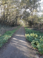
Parcours de 2h15 sur 10 kms avec un départ au plan d'eau de la Verdière. C'est un circuit pédestre qui traverse les Basloirs, le Domaine de la Forêt et la Haute Noë.
Hébergements à proximité

infos parcours (1)
1
Départ du circuit Plan d'eau de la Verdière
Ce plan d'eau dédié à la pêche a été mis en service en 1985 .Vous y trouverez également un parcours d'orientation.
Informations complémentaires
Complexe Philippe Touzot
44850 SAINT-MARS-DU-DÉSERT
44850 SAINT-MARS-DU-DÉSERT
kilomètre
0,00
latitude
47.3582
altitude
64
m
longitude
-1.41348


