
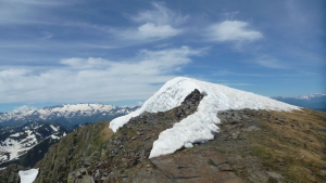
Pic de Crabère
- Mis à jour le 25/06/2018
- Identifiant 319156
Sélectionner le fond de carte

PLAN IGN

PHOTOS AERIENNES

CARTES IGN MULTI-ECHELLES

TOP 25 IGN

CARTES DES PENTES

PARCELLES CADASTRALES

CARTES OACI

CARTES 1950 IGN

CARTE DE L’ETAT-MAJOR (1820-1866)

Open Street Map
Afficher les points d'intérêt à proximité
Hébergements
Informations
Lieux d'intérêts
Producteurs
Restauration
Services et Commerces
Autre
Echelle
|
durée / niveau
Rando pédestre
|
distance
26,7 km
type parcours
Boucle
|
|||||||||
|
Lieu de départ
144 freychendech
09800 Sentein |
accessibilite
|
|||||||||
|
prestations payantes
Non
|
type(s) de sol
Terre
Herbe Rochers |
|||||||||
Photos & vidéos (1)
|
description
Sortie PyC de Juin, belle sortie mais longue.
Indice IBP 189
Indice IBP 189
Hébergements à proximité

infos parcours (16)
1
PyC0618 Point 1
Parking42.8677 ; 0.927862
Informations complémentaires
143 freychendech
09800 Sentein
09800 Sentein
kilomètre
0,02
latitude
42.8677
altitude
820
m
longitude
0.927862
2
09800 Sentein
PyC0618 Point 2
Passerelle des Pichès42.859117 ; 0.903003
Informations complémentaires
09800 Sentein
kilomètre
3,43
latitude
42.8591
altitude
1115
m
longitude
0.903003
3
09800 Sentein
PyC0618 Point 3
Fontaines froides42.850225 ; 0.886545
Informations complémentaires
09800 Sentein
kilomètre
5,67
latitude
42.8502
altitude
1409
m
longitude
0.886545
4
09800 Sentein
PyC0618 Point 4
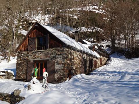
Cabane d'Illau42.845277 ; 0.88235
Informations complémentaires
09800 Sentein
kilomètre
6,37
latitude
42.8453
altitude
1484
m
longitude
0.88235
5
09800 Sentein
PyC0618 Point 5
Barrage d'Araing42.8342 ; 0.876975
Informations complémentaires
09800 Sentein
kilomètre
8,15
latitude
42.8342
altitude
1896
m
longitude
0.876975
6
31440 Melles
PyC0618 Point 6
Col d'auéran42.83568 ; 0.860206
Informations complémentaires
31440 Melles
kilomètre
9,66
latitude
42.8357
altitude
2177
m
longitude
0.860206
7
09800 Sentein
PyC0618 Point 7
Début ligne de crête vers le pic42.8294 ; 0.858886
Informations complémentaires
09800 Sentein
kilomètre
10,42
latitude
42.8294
altitude
2327
m
longitude
0.858886
8
09800 Sentein
PyC0618 Point 8
Pic de Crabère42.8257 ; 0.858371
Informations complémentaires
09800 Sentein
kilomètre
11,17
latitude
42.8257
altitude
2620
m
longitude
0.858371
9
31440 Melles
PyC0618 Point 9
Pic de Lanères42.838307 ; 0.859841
Informations complémentaires
31440 Melles
kilomètre
13,03
latitude
42.8383
altitude
2241
m
longitude
0.859841
10
31440 Melles
PyC0618 Point 10
Etang d'Uls avant montée vers Pic Noir42.8499 ; 0.852556
Informations complémentaires
31440 Melles
kilomètre
15,31
latitude
42.8499
altitude
1965
m
longitude
0.852556
11
09800 Antras
PyC0618 Point 11
Pic Noir et Le Pièlé de Mil42.856997 ; 0.850496
Informations complémentaires
09800 Antras
kilomètre
16,00
latitude
42.857
altitude
2109
m
longitude
0.850496
12
31440 Melles
PyC0618 Point 12
Col d'Auarde42.861464 ; 0.848951
Informations complémentaires
31440 Melles
kilomètre
16,49
latitude
42.8615
altitude
1952
m
longitude
0.848951
13
09800 Antras
PyC0618 Point 13
Cabane des Pugues42.8618 ; 0.859187
Informations complémentaires
09800 Antras
kilomètre
17,41
latitude
42.8618
altitude
1735
m
longitude
0.859187
14
09800 Antras
PyC0618 Point 14
Cabane du Troumas42.8598 ; 0.886095
Informations complémentaires
09800 Antras
kilomètre
19,74
latitude
42.8598
altitude
1489
m
longitude
0.886095
15
09800 Antras
PyC0618 Point 15
Cabane Forestière de l'Isard42.8573 ; 0.881095
Informations complémentaires
09800 Antras
kilomètre
20,44
latitude
42.8573
altitude
1391
m
longitude
0.881095
16
09800 Antras
PyC0618 Point 16
Chapelle de l'Isard42.8573 ; 0.888541
Informations complémentaires
09800 Antras
kilomètre
21,08
latitude
42.8573
altitude
1325
m
longitude
0.888541


