
Boucle de Manthelan en passant par le Château de Grillemont
- Thématique Randonnée
- Mis à jour le 30/11/2015
- Identifiant 36300
Sélectionner le fond de carte

PLAN IGN

PHOTOS AERIENNES

CARTES IGN MULTI-ECHELLES

TOP 25 IGN

CARTES DES PENTES

PARCELLES CADASTRALES

CARTES OACI

CARTES 1950 IGN

CARTE DE L’ETAT-MAJOR (1820-1866)

Open Street Map
Afficher les points d'intérêt à proximité
Hébergements
Informations
Lieux d'intérêts
Producteurs
Restauration
Services et Commerces
Autre
Echelle
|
durée / niveau
Randonnée/tourisme équestre
|
distance
19,4 km
type parcours
Boucle
|
|||||||||
|
Lieu de départ
3 rte de sainte-maure
37240 Manthelan |
accessibilite
|
|||||||||
|
prestations payantes
Non
|
type(s) de sol
Bitume
Terre Herbe |
|||||||||
Photos & vidéos (1)
|
description
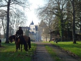
Parcours cavalier , départ sur le terrain communal de Manthelan( demander l'autorisation de stationnement à la Mairie tel:0247912300) Belle balade alternant plaine et forêt avec possibilité de visiter le Château de Grillemont sur demande l'après midi en période estivale.
Hébergements à proximité

Points d'interêt (1)
A
37240 La Chapelle-Blanche-Saint-Martin
Voir la fiche du point d'intéret »
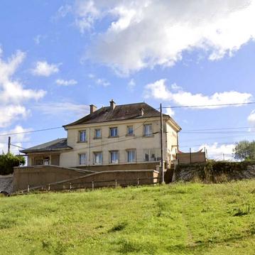
Château de Grillemont
Art & Musées
Visite du château possible en période estivale.
Informations complémentaires
37240 La Chapelle-Blanche-Saint-Martin
kilomètre
8,97
latitude
47.0936
altitude
113
m
longitude
0.768056

