
Pic Saint Barthélémy option 1
- Mis à jour le 30/05/2020
- Identifiant 980458
Sélectionner le fond de carte

PLAN IGN

PHOTOS AERIENNES

CARTES IGN MULTI-ECHELLES

TOP 25 IGN

CARTES DES PENTES

PARCELLES CADASTRALES

CARTES OACI

CARTES 1950 IGN

CARTE DE L’ETAT-MAJOR (1820-1866)

Open Street Map
Afficher les points d'intérêt à proximité
Hébergements
Informations
Lieux d'intérêts
Producteurs
Restauration
Services et Commerces
Autre
Echelle
|
durée / niveau
Rando pédestre
|
distance
11,4 km
type parcours
Boucle
|
|||||||||
|
Lieu de départ
457 les monts d'olmes
09300 Montferrier |
accessibilite
|
|||||||||
|
prestations payantes
Non
|
type(s) de sol
|
|||||||||
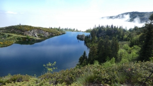
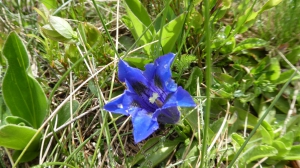
Photos & vidéos (2)
|
|
description
Départ du parking de la station des Monts d'Olmes. Aller et retour par le col de Girabal, variante retour par les pistes de ski à partir du lac de Fage Belle. Joli rando qui offre un beau panorama au sommet.
Nombreuses options possibles.
Nombreuses options possibles.
Hébergements à proximité

infos parcours (12)
1
PLe0520 Point 1
Parking
Informations complémentaires
kilomètre
0,27
latitude
42.8459
altitude
1458
m
longitude
1.74382
2
PLe0520 Point 2
Départ route forestière
Informations complémentaires
kilomètre
0,44
latitude
42.8424
altitude
1494
m
longitude
1.74704
3
PLe0520 Point 3
Jonction Aller Retour.Aller prendre main gauche.
Informations complémentaires
kilomètre
0,96
latitude
42.8396
altitude
1556
m
longitude
1.74481
4
PLe0520 Point 4
Etangs de Fage Belle
Informations complémentaires
kilomètre
2,41
latitude
42.832
altitude
1752
m
longitude
1.74884
5
PLe0520 Point 5
Intersection Aller Retour.Aller prendre main gauche. Tronc commun entre points 5 et 6.
Informations complémentaires
kilomètre
2,63
latitude
42.8304
altitude
1773
m
longitude
1.74951
6
PLe0520 Point 6
Intersection Aller Retour.Aller prendre main gauche.Tronc commun entre points 5 et 6.
Informations complémentaires
kilomètre
3,19
latitude
42.8282
altitude
1864
m
longitude
1.75404
7
PLe0520 Point 6bis
Repère visuel gros rocher, depuis ce point descendre pour rejoindre le fond du vallon avant de remonter vers le col.
Informations complémentaires
kilomètre
3,66
latitude
42.8249
altitude
1850
m
longitude
1.75687
8
PLe0520 Point 7
Début montée vers col de Giral
Informations complémentaires
kilomètre
3,91
latitude
42.8252
altitude
1807
m
longitude
1.75921
9
PLe0520 Point 10
Col de l'étang d'ApplyMain droite pour retour
Informations complémentaires
kilomètre
4,03
latitude
42.8227
altitude
2029
m
longitude
1.75171
10
PLe0520 Point 8
Col de Girabal
Informations complémentaires
kilomètre
4,60
latitude
42.8204
altitude
2002
m
longitude
1.76142
11
PLe0520 Point 11
Point haut entre les 2 cols
Informations complémentaires
kilomètre
4,98
latitude
42.8196
altitude
2164
m
longitude
1.75558
12
PLe0520 Point 9
Pic de Saint Barthélémy
Informations complémentaires
kilomètre
5,53
latitude
42.8192
altitude
2341
m
longitude
1.7712

