
Petite boucle du Houx et du Long Boyau
- Thématique Balade
- Mis à jour le 31/12/2021
- Identifiant 1522115
Sélectionner le fond de carte

PLAN IGN

PHOTOS AERIENNES

CARTES IGN MULTI-ECHELLES

TOP 25 IGN

CARTES DES PENTES

PARCELLES CADASTRALES

CARTES OACI

CARTES 1950 IGN

CARTE DE L’ETAT-MAJOR (1820-1866)

Open Street Map
Afficher les points d'intérêt à proximité
Hébergements
Informations
Lieux d'intérêts
Producteurs
Restauration
Services et Commerces
Autre
Echelle
|
durée / niveau
Rando pédestre
|
distance
5,1 km
type parcours
Boucle
|
|||||||||
|
Lieu de départ
77300 Fontainebleau
|
accessibilite
|
|||||||||
|
prestations payantes
Non
|
type(s) de sol
Sable
Terre Rochers |
|||||||||
Photos & vidéos (1)
|
description
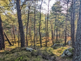
Balade dans la forêt de Fontainebleau avec des rochers
Hébergements à proximité

infos parcours (11)
1
Parking de l'Ermitage à Franchard
Informations complémentaires
kilomètre
0,00
latitude
48.4085
altitude
133
m
longitude
2.6361
2
Carrefour du Houx - Sentier bleu n°7
Informations complémentaires
kilomètre
0,66
latitude
48.4065
altitude
132
m
longitude
2.64234
3
7-8
Informations complémentaires
kilomètre
1,11
latitude
48.4062
altitude
112
m
longitude
2.64808
4
Carrefour - Sentier bleu n°8
Informations complémentaires
kilomètre
1,30
latitude
48.4052
altitude
98
m
longitude
2.65005
5
czrrf
Informations complémentaires
kilomètre
1,63
latitude
48.4029
altitude
103
m
longitude
2.65255
6
Carrefour - Sentier bleu n°8
Informations complémentaires
kilomètre
1,66
latitude
48.4028
altitude
105
m
longitude
2.65289
7
Rte
Informations complémentaires
kilomètre
1,84
latitude
48.4016
altitude
91
m
longitude
2.65421
8
Point de vue
Informations complémentaires
kilomètre
2,07
latitude
48.3999
altitude
120
m
longitude
2.65521
9
Carrefour - Route du Long Boyau
Informations complémentaires
kilomètre
2,79
latitude
48.3974
altitude
86
m
longitude
2.65311
10
Route du Chêne Rouge
Informations complémentaires
kilomètre
3,81
latitude
48.3981
altitude
94
m
longitude
2.63955
11
Parking de l'Ermitage à Franchard
Informations complémentaires
kilomètre
10,21
latitude
48.4085
altitude
133
m
longitude
2.6361
YANIC
Note moyenne
Cartes associées

