
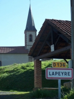
Chemin des lavoirs Lapeyre, Bernadets-Débat, Antin
- Mis à jour le 01/08/2025
- Identifiant 1729955
Sélectionner le fond de carte

PLAN IGN

PHOTOS AERIENNES

CARTES IGN MULTI-ECHELLES

TOP 25 IGN

CARTES DES PENTES

PARCELLES CADASTRALES

CARTES OACI

CARTES 1950 IGN

CARTE DE L’ETAT-MAJOR (1820-1866)

Open Street Map
Afficher les points d'intérêt à proximité
Hébergements
Informations
Lieux d'intérêts
Producteurs
Restauration
Services et Commerces
Autre
Echelle
|
durée / niveau
Rando pédestre
|
distance
11,8 km
type parcours
|
|||||||||
|
Lieu de départ
17 Route de Trie
65220 LAPEYRE |
accessibilite
|
|||||||||
|
prestations payantes
Non
|
type(s) de sol
|
|||||||||
Photos & vidéos (1)
|
description
Départ du parking face à la mairie de Lapeyre
Remonter sur la D6 sur 100 m.
1 - Prendre à gauche vers la Maison de la Communication
2 - Au Y prendre à droite et continuer tout droit sur 1 km.
3 - Prendre à droite dans le bois le chemin de César (attention passage dangereux)
Continuer dans le bois jusqu’à revenir sur la D6. Soyez prudents à l’intersection
4 - Prendre à droite sur la D6 jusqu’au pâté de maisons.
5 - Prendre le chemin entre les maisons et continuer tout droit sur le sentier qui longe le bois
6 - Rentrer dans le bois à gauche pendant 800 m jusqu’à arriver derrière une maison en L (construction typique de notre région)
7 - Prendre à droite de la maison puis à 40 m prendre à gauche sur la route
8 - Continuer sur la route pendant 70 m. A la maison, prendre à gauche dans le bois et continuer tout droit jusqu’à la sortie du bois, puis
70 m sur le chemin.
9 - Prendre à gauche sur la route (Chemin d’Antin «La Ribère»).
10 - Prendre à gauche la route de l’ancienne côte.
11 - Prendre à gauche pendant 350 m, puis prendre à gauche jusqu’à la D6.
12 - Prendre la D6 pendant 900 m puis dans le virage prendre à gauche sur le sentier qui monte
dans le bois.
13 - A la sortie du bois vous arrivez sur le site de l’ancienne tuilerie. Continuer tout droit sur la D6 pour revenir au point de départ à Lapeyre (plus court) ou reprenez le chemin emprunté initialement.
Hébergements à proximité

infos parcours (1)
1
Parking
Départ randonnée
Informations complémentaires
5 Le Clos
65220 LAPEYRE
65220 LAPEYRE
kilomètre
0,01
latitude
43.323
altitude
312
m
longitude
0.339598
Points d'interêt (1)
A
Voir la fiche du point d'intéret »
Produits bio à la ferme
Produit de la ferme
Ouvert samedi matin
Informations complémentaires
2 Les Loumagnes
65220 BERNADETS-DEBAT
65220 BERNADETS-DEBAT
kilomètre
3,97
latitude
43.3385
altitude
368
m
longitude
0.3268
