
Chemin de Bonahont Bonnefont
- Mis à jour le 01/08/2025
- Identifiant 1730839
Sélectionner le fond de carte

PLAN IGN

PHOTOS AERIENNES

CARTES IGN MULTI-ECHELLES

TOP 25 IGN

CARTES DES PENTES

PARCELLES CADASTRALES

CARTES OACI

CARTES 1950 IGN

CARTE DE L’ETAT-MAJOR (1820-1866)

Open Street Map
Afficher les points d'intérêt à proximité
Hébergements
Informations
Lieux d'intérêts
Producteurs
Restauration
Services et Commerces
Autre
Echelle
|
durée / niveau
Rando pédestre
|
distance
12,3 km
type parcours
|
|||||||||
|
Lieu de départ
6 Parc du Château
65220 BONNEFONT |
accessibilite
|
|||||||||
|
prestations payantes
Non
|
type(s) de sol
|
|||||||||
Photos & vidéos (1)
|
description
Départ de la salle des fêtes de Bonnefont.
Prendre la D39, vers le nord jusqu’au calvaire
1 - Prendre à gauche. Puis rester à gauche.
2 - Au nord de la maison, (circuit commun avec le N°9) continuer jusqu’à la D17. Tourner à droite sur 150 m puis bifurquer sur la gauche. Au Y prendre le chemin de droite, à travers les coteaux de Bonnefont.
3 - Prendre à droite sur 200 m, puis à gauche. Traverser une zone agricole sur la droite.
4 - Continuer tout droit vers la colline
5 - Tourner à gauche dans le bois et poursuivre le chemin de Sainte-Barbe
6 - Prendre à droite, puis descendre vers la D21.
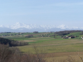
7 - Au calvaire (circuit en commun avec le N°6), prendre à gauche la D21 sur 100 m puis tourner à droite et monter par un chemin de terre vers le bois de Bonnefont. Ce bois est composé de chênes, châtaigniers, et de plantations de résineux.
8 - Continuer tout droit dans la forêt de Bonnefont ou emprunter la variante (Prendre le 1er chemin à gauche, puis continuer tout droit et rejoindre le point n°12 à gauche)
9 - Continuer sur le chemin de crête 10 - A l’intersection tourner à gauche et descendre.
11 - A la sortie du bois, continuer à gauche sur le chemin empierré. Continuer tout droit.
12 - Tourner à gauche.
13 - Tourner à droite, puis à gauche pour rejoindre la D17.
14 - Traverser la D17 et descendre vers le village de Bonnefont
15 - Tourner à gauche. Traverser la place du village et passer devant l’église. A 100 m continuer tout droit en franchissant la D21. Rejoindre le point de départ.
Prendre la D39, vers le nord jusqu’au calvaire
1 - Prendre à gauche. Puis rester à gauche.
2 - Au nord de la maison, (circuit commun avec le N°9) continuer jusqu’à la D17. Tourner à droite sur 150 m puis bifurquer sur la gauche. Au Y prendre le chemin de droite, à travers les coteaux de Bonnefont.
3 - Prendre à droite sur 200 m, puis à gauche. Traverser une zone agricole sur la droite.
4 - Continuer tout droit vers la colline
5 - Tourner à gauche dans le bois et poursuivre le chemin de Sainte-Barbe
6 - Prendre à droite, puis descendre vers la D21.
7 - Au calvaire (circuit en commun avec le N°6), prendre à gauche la D21 sur 100 m puis tourner à droite et monter par un chemin de terre vers le bois de Bonnefont. Ce bois est composé de chênes, châtaigniers, et de plantations de résineux.
8 - Continuer tout droit dans la forêt de Bonnefont ou emprunter la variante (Prendre le 1er chemin à gauche, puis continuer tout droit et rejoindre le point n°12 à gauche)
9 - Continuer sur le chemin de crête 10 - A l’intersection tourner à gauche et descendre.
11 - A la sortie du bois, continuer à gauche sur le chemin empierré. Continuer tout droit.
12 - Tourner à gauche.
13 - Tourner à droite, puis à gauche pour rejoindre la D17.
14 - Traverser la D17 et descendre vers le village de Bonnefont
15 - Tourner à gauche. Traverser la place du village et passer devant l’église. A 100 m continuer tout droit en franchissant la D21. Rejoindre le point de départ.
Hébergements à proximité

infos parcours (5)
1
Parking
Départ randonnée
Informations complémentaires
6 Parc du Château
65220 BONNEFONT
65220 BONNEFONT
kilomètre
0,01
latitude
43.2513
altitude
299
m
longitude
0.345573
2
BONNEFONT
Variante raccourci (shortcut)
Informations complémentaires
BONNEFONT
kilomètre
8,87
latitude
43.2437
altitude
417
m
longitude
0.328732
3
Attention traversée dangereuse
Informations complémentaires
18 Route de Montastruc
65220 BONNEFONT
65220 BONNEFONT
kilomètre
11,07
latitude
43.2457
altitude
327
m
longitude
0.339418
4
Attention traversée dangereuse
Informations complémentaires
14 Lahontagne
65220 BONNEFONT
65220 BONNEFONT
kilomètre
23,52
latitude
43.2545
altitude
324
m
longitude
0.33812
5
Attention traversée dangereuse
Informations complémentaires
kilomètre
21,24
latitude
43.2499
altitude
393
m
longitude
0.324604
