Enteneck - RF du Schnockenlochmatt
- Mis à jour le 14/11/2022
- Identifiant 1870793
Sélectionner le fond de carte

PLAN IGN

PHOTOS AERIENNES

CARTES IGN MULTI-ECHELLES

TOP 25 IGN

CARTES DES PENTES

PARCELLES CADASTRALES

CARTES OACI

CARTES 1950 IGN

CARTE DE L’ETAT-MAJOR (1820-1866)

Open Street Map
Afficher les points d'intérêt à proximité
Hébergements
Informations
Lieux d'intérêts
Producteurs
Restauration
Services et Commerces
Autre
Echelle
|
durée / niveau
Rando pédestre
|
distance
12,6 km
type parcours
Boucle
|
|||||||||
|
Lieu de départ
57850 Dabo
|
accessibilite
|
|||||||||
|
prestations payantes
Non
|
type(s) de sol
Bitume
Graviers Sable Terre |
|||||||||
|
Mots clés
dabo, zorn, Enteneck
|
||||||||||
Photos & vidéos (1)
|
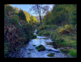
description
Enteck, remontée de la Zorn blanche jusquà Herrenmuhlen. chemin qui remonte en rive gauche du Schnockenloch. Retour par la route forestière du Schnockenlochmatt et sous l'Altdorf.