Etape 2 Chemin Pèlerin de Chastellux-sur-Cure à Quarré-les-Tombes
- Thématique Randonnée
- Mis à jour le 12/03/2023
- Identifiant 1960120
Sélectionner le fond de carte

PLAN IGN

PHOTOS AERIENNES

CARTES IGN MULTI-ECHELLES

TOP 25 IGN

CARTES DES PENTES

PARCELLES CADASTRALES

CARTES OACI

CARTES 1950 IGN

CARTE DE L’ETAT-MAJOR (1820-1866)

Open Street Map
Afficher les points d'intérêt à proximité
Hébergements
Informations
Lieux d'intérêts
Producteurs
Restauration
Services et Commerces
Autre
Echelle
|
durée / niveau
Rando pédestre
|
distance
18,4 km
type parcours
Aller Simple
|
|||||||||
|
Lieu de départ
89630 Chastellux-sur-Cure
|
accessibilite
|
|||||||||
|
prestations payantes
Non
|
type(s) de sol
Bitume
Graviers Terre Herbe |
|||||||||
Photos & vidéos (1)
|
description
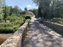
Cette étape du Chemin Pèlerin de Vézelay à Autun (Chemin de Cluny vers Saint-Jacques-de-Compostelle) vous mènera au Barrage du Crescent, puis le hameau de Villaine et celui de Villers les Protots avant de rejoindre Quarté-les-Tombes.