Circuit moto ou voiture : la Haute Cornouaille et ses environs
- Mis à jour le 23/12/2024
- Identifiant 2409345
Sélectionner le fond de carte

PLAN IGN

PHOTOS AERIENNES

CARTES IGN MULTI-ECHELLES

TOP 25 IGN

CARTES DES PENTES

PARCELLES CADASTRALES

CARTES OACI

CARTES 1950 IGN

CARTE DE L’ETAT-MAJOR (1820-1866)

Open Street Map
Afficher les points d'intérêt à proximité
Hébergements
Informations
Lieux d'intérêts
Producteurs
Restauration
Services et Commerces
Autre
Echelle
|
durée / niveau
Camping car
|
distance
182,4 km
type parcours
|
|||||||||
|
Lieu de départ
7 Allée Notre Dame des Portes
29520 CHÂTEAUNEUF-DU-FAOU |
accessibilite
|
|||||||||
|
prestations payantes
Non
|
type(s) de sol
|
|||||||||
Photos & vidéos (3)
|

|
|
description
Ce circuit à travers la Haute Cornouaille et ses environs vous emmène à la découverte des pépites patrimoniales ou naturelles du Centre-Finistère. 2h30 de trajet : temps d'arrêt non compris. Possibilité de faire des boucles variantes (185 km ou 105 km).Nous vous conseillons de parcourir ce circuit sur 2 jours (parfait pour un week-end !)
Hébergements à proximité
infos parcours (12)
1
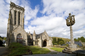
1. Châteauneuf-du-Faou : Canal de Nantes à Brest, chapelle Notre-Dame des Portes, Penn ar Pont
Informations complémentaires
7 Allée Notre Dame des Portes
29520 CHÂTEAUNEUF-DU-FAOU
29520 CHÂTEAUNEUF-DU-FAOU
kilomètre
0,00
latitude
48.1854
altitude
83
m
longitude
-3.80943
2
2. Saint-Goazec : Domaine de Trévarez
Informations complémentaires
D36
29520 SAINT-GOAZEC
29520 SAINT-GOAZEC
kilomètre
4,89
latitude
48.1536
altitude
170
m
longitude
-3.79912
3
3. Spézet : Chapelle Notre-Dame du Crann
Informations complémentaires
293 Bardero
29540 SPÉZET
29540 SPÉZET
kilomètre
13,27
latitude
48.1869
altitude
81
m
longitude
-3.72394
4
4. Carnoët : La Vallée des Saints
Informations complémentaires
3 Quenequillec
22160 CARNOËT
22160 CARNOËT
kilomètre
43,13
latitude
48.3711
altitude
234
m
longitude
-3.54103
5
5. Collorec : La Plage Verte
Informations complémentaires
1 Route du Stade
29530 COLLOREC
29530 COLLOREC
kilomètre
66,15
latitude
48.2896
altitude
122
m
longitude
-3.77586
6
6. Plonévez-du-Faou : Chapelle de Saint-Herbot
Informations complémentaires
13 Saint-Herbot
29530 PLONÉVEZ-DU-FAOU
29530 PLONÉVEZ-DU-FAOU
kilomètre
72,53
latitude
48.3276
altitude
134
m
longitude
-3.80921
7
7. Huelgoat : Lac et forêt
Informations complémentaires
16 Rue du Lac
29690 HUELGOAT
29690 HUELGOAT
kilomètre
80,02
latitude
48.3643
altitude
166
m
longitude
-3.74771
8
8. Brennilis : Lac Saint-Michel
Informations complémentaires
Nestavel Bras
29690 BRENNILIS
29690 BRENNILIS
kilomètre
93,19
latitude
48.359
altitude
227
m
longitude
-3.88006
9
29190 SAINT-RIVOAL
9. Brasparts : Chapelle Saint-Michel
Informations complémentaires
29190 SAINT-RIVOAL
kilomètre
105,98
latitude
48.3503
altitude
380
m
longitude
-3.94572
10
10. Pleyben : Enclos Paroissial
Informations complémentaires
48 Place Charles de Gaulle
29190 PLEYBEN
29190 PLEYBEN
kilomètre
123,11
latitude
48.2268
altitude
117
m
longitude
-3.96978
11
11. Gouézec : La Roche du Feu
Informations complémentaires
242-241 Kerarmet
29190 GOUÉZEC
29190 GOUÉZEC
kilomètre
133,94
latitude
48.157
altitude
241
m
longitude
-3.96456
12
12. Saint-Thois : Canal de Nantes à Brest, Stervinou
Informations complémentaires
Stervinou
29520 SAINT-THOIS
29520 SAINT-THOIS
kilomètre
174,95
latitude
48.1681
altitude
33
m
longitude
-3.87217


