
Saint-Alban 2
- Mis à jour le 27/11/2024
- Identifiant 2644079
Sélectionner le fond de carte

PLAN IGN

PHOTOS AERIENNES

CARTES IGN MULTI-ECHELLES

TOP 25 IGN

CARTES DES PENTES

PARCELLES CADASTRALES

CARTES OACI

CARTES 1950 IGN

CARTE DE L’ETAT-MAJOR (1820-1866)

Open Street Map
Afficher les points d'intérêt à proximité
Hébergements
Informations
Lieux d'intérêts
Producteurs
Restauration
Services et Commerces
Autre
Echelle
|
durée / niveau
Rando pédestre
|
distance
0,0 km
type parcours
|
|||||||||
|
Lieu de départ
Lablachere
|
accessibilite
|
|||||||||
|
prestations payantes
Non
|
type(s) de sol
|
|||||||||
Photos & vidéos (1)
|
description
Régis Froment
Hébergements à proximité


infos parcours (10)
1
Combe d'Amady
Informations complémentaires
kilomètre
0,00
latitude
44.4588
altitude
269
m
longitude
4.23001
2
Réméjadou
Continuer tout droit direction Flandrin
Informations complémentaires
kilomètre
0,00
latitude
44.4378
altitude
202
m
longitude
4.25903
3
Flandrin
Informations complémentaires
kilomètre
0,00
latitude
44.435
altitude
196
m
longitude
4.25828
4
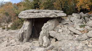
Dolmen 1 FontMéjanne
Informations complémentaires
kilomètre
0,00
latitude
44.429
altitude
157
m
longitude
4.26425
5
Dolmens 2-3
Informations complémentaires
kilomètre
0,00
latitude
44.4279
altitude
145
m
longitude
4.26428
6
Cote 205
Informations complémentaires
kilomètre
0,00
latitude
44.4397
altitude
204
m
longitude
4.27634
7
Cote 236
Prendre piste à droite
Informations complémentaires
kilomètre
0,00
latitude
44.4503
altitude
236
m
longitude
4.27666
8
Robert
Informations complémentaires
kilomètre
0,00
latitude
44.4414
altitude
203
m
longitude
4.29939
9
Cote 115
Prendre à droite.Raccourci possible direct parking à gauche
Informations complémentaires
kilomètre
0,00
latitude
44.431
altitude
118
m
longitude
4.30183
10
Dolmen du Calvaire
Informations complémentaires
kilomètre
0,00
latitude
44.4289
altitude
165
m
longitude
4.29235
PATRICIA
Note moyenne
Cartes associées
