
Otsaxar, Otsamuho et Errola en boucle depuis les Aldudes
- Mis à jour le 30/03/2025
- Identifiant 2808098
Sélectionner le fond de carte

PLAN IGN

PHOTOS AERIENNES

CARTES IGN MULTI-ECHELLES

TOP 25 IGN

CARTES DES PENTES

PARCELLES CADASTRALES

CARTES OACI

CARTES 1950 IGN

CARTE DE L’ETAT-MAJOR (1820-1866)

Open Street Map
Afficher les points d'intérêt à proximité
Hébergements
Informations
Lieux d'intérêts
Producteurs
Restauration
Services et Commerces
Autre
Echelle
|
durée / niveau
Rando pédestre
|
distance
12,2 km
type parcours
Boucle
|
|||||||||
|
Lieu de départ
64 Errintaineko bidea
64430 Aldudes |
accessibilite
|
|||||||||
|
prestations payantes
Non
|
type(s) de sol
Bitume
Graviers Terre Herbe Rochers |
|||||||||
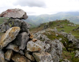
Photos & vidéos (1)
|
Hébergements à proximité

infos parcours (13)
1
Parking de l'église
Informations complémentaires
kilomètre
0,01
latitude
43.0985
altitude
369
m
longitude
-1.4282
2
Route D948
Informations complémentaires
kilomètre
11,15
latitude
43.0897
altitude
385
m
longitude
-1.42442
3
Bifurcation
Informations complémentaires
kilomètre
14,34
latitude
43.0873
altitude
498
m
longitude
-1.41296
4
Informations complémentaires
kilomètre
15,81
latitude
43.0912
altitude
686
m
longitude
-1.40385
5
Informations complémentaires
kilomètre
17,55
latitude
43.0853
altitude
907
m
longitude
-1.38973
6
Informations complémentaires
kilomètre
18,29
latitude
43.0913
altitude
825
m
longitude
-1.39312
7
Informations complémentaires
kilomètre
18,82
latitude
43.0956
altitude
899
m
longitude
-1.3953
8
Informations complémentaires
kilomètre
19,82
latitude
43.1035
altitude
823
m
longitude
-1.3912
9
Bifurcation
Informations complémentaires
kilomètre
20,37
latitude
43.1004
altitude
777
m
longitude
-1.39409
10
Bifurcation
Informations complémentaires
kilomètre
21,22
latitude
43.1001
altitude
749
m
longitude
-1.40255
11
Carrefour des pistes
Informations complémentaires
kilomètre
22,22
latitude
43.0956
altitude
632
m
longitude
-1.40869
12
Informations complémentaires
kilomètre
23,77
latitude
43.0982
altitude
492
m
longitude
-1.422
13
Parking de l'
Informations complémentaires
kilomètre
24,47
latitude
43.0986
altitude
369
m
longitude
-1.4282

