De Sainte-Foy-l'Argentière à Saint-Martin-en-Haut
- Mis à jour le 23/12/2024
- Identifiant 2811290
Sélectionner le fond de carte

PLAN IGN

PHOTOS AERIENNES

CARTES IGN MULTI-ECHELLES

TOP 25 IGN

CARTES DES PENTES

PARCELLES CADASTRALES

CARTES OACI

CARTES 1950 IGN

CARTE DE L’ETAT-MAJOR (1820-1866)

Open Street Map
Afficher les points d'intérêt à proximité
Hébergements
Informations
Lieux d'intérêts
Producteurs
Restauration
Services et Commerces
Autre
Echelle
|
durée / niveau
Rando pédestre
|
distance
14,2 km
type parcours
|
|||||||||
|
Lieu de départ
3 Route de Lyon
69610 SAINTE-FOY-L'ARGENTIÈRE |
accessibilite
|
|||||||||
|
prestations payantes
Non
|
type(s) de sol
|
|||||||||
Photos & vidéos (1)
|
description
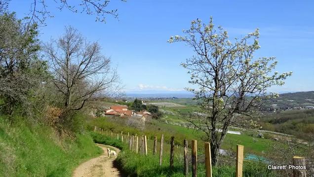
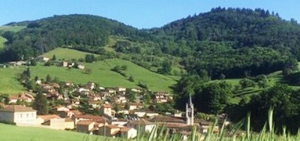
Entre les monts du Beaujolais et le massif du Pilat, aux portes des métropoles de Lyon et Saint-Étienne, ce territoire aux doux vallons verdoyants est ponctué de villages et hameaux accueillants.
Hébergements à proximité
Balisage
Jaune
infos parcours (18)
1
Le Camard
Informations complémentaires
9 Route de Lyon
69610 SAINTE-FOY-L'ARGENTIÈRE
69610 SAINTE-FOY-L'ARGENTIÈRE
kilomètre
0,01
latitude
45.71
altitude
425
m
longitude
4.46711
2
Place de la gare
Informations complémentaires
171 Grande Rue
69610 SAINTE-FOY-L'ARGENTIÈRE
69610 SAINTE-FOY-L'ARGENTIÈRE
kilomètre
0,19
latitude
45.7094
altitude
424
m
longitude
4.46913
3
L'église
Informations complémentaires
406 Grande Rue
69610 SAINTE-FOY-L'ARGENTIÈRE
69610 SAINTE-FOY-L'ARGENTIÈRE
kilomètre
0,35
latitude
45.709
altitude
428
m
longitude
4.47108
4
Le Moulin Blanc
Informations complémentaires
68 Grande Rue
69610 SAINTE-FOY-L'ARGENTIÈRE
69610 SAINTE-FOY-L'ARGENTIÈRE
kilomètre
0,68
latitude
45.708
altitude
440
m
longitude
4.47506
5
Les Rivières
Informations complémentaires
600 Rue des Prairies
69610 SAINTE-FOY-L'ARGENTIÈRE
69610 SAINTE-FOY-L'ARGENTIÈRE
kilomètre
1,27
latitude
45.704
altitude
464
m
longitude
4.47989
6
Le Bourg
Informations complémentaires
10 Rue des Lavandières
69610 SAINT-GENIS-L'ARGENTIÈRE
69610 SAINT-GENIS-L'ARGENTIÈRE
kilomètre
2,89
latitude
45.7094
altitude
475
m
longitude
4.49251
7
Les Planches
Informations complémentaires
20 Route de Montromant
69610 SAINT-GENIS-L'ARGENTIÈRE
69610 SAINT-GENIS-L'ARGENTIÈRE
kilomètre
3,12
latitude
45.7108
altitude
492
m
longitude
4.49444
8
69610 SAINT-GENIS-L'ARGENTIÈRE
La Guaise
Informations complémentaires
69610 SAINT-GENIS-L'ARGENTIÈRE
kilomètre
4,53
latitude
45.7007
altitude
675
m
longitude
4.50153
9
Chervolin
Informations complémentaires
99 Route de Chervolin
69610 MONTROMANT
69610 MONTROMANT
kilomètre
5,50
latitude
45.7012
altitude
721
m
longitude
4.50965
10
La Grande Goutte
Informations complémentaires
474 Chemin de la Grande Goutte
69610 MONTROMANT
69610 MONTROMANT
kilomètre
7,43
latitude
45.7012
altitude
578
m
longitude
4.52755
11
La Forêt
Informations complémentaires
890 Chemin de la Forêt
69850 DUERNE
69850 DUERNE
kilomètre
8,77
latitude
45.6933
altitude
716
m
longitude
4.52875
12
Le Loyard
Informations complémentaires
2 Route du Col
69850 DUERNE
69850 DUERNE
kilomètre
9,79
latitude
45.6854
altitude
791
m
longitude
4.53081
13
Le Rocher
Informations complémentaires
1 Chemin des Étoiles
69850 DUERNE
69850 DUERNE
kilomètre
9,91
latitude
45.6857
altitude
795
m
longitude
4.53225
14
Le Pontel
Informations complémentaires
45 Chemin du Pontel
69850 DUERNE
69850 DUERNE
kilomètre
10,54
latitude
45.6809
altitude
766
m
longitude
4.53235
15
La Prat
Informations complémentaires
70 Chemin de Clavany
69850 SAINT-MARTIN-EN-HAUT
69850 SAINT-MARTIN-EN-HAUT
kilomètre
12,13
latitude
45.6697
altitude
694
m
longitude
4.5427
16
Croix Carrière
Informations complémentaires
40 Chemin des Marechaudes
69850 SAINT-MARTIN-EN-HAUT
69850 SAINT-MARTIN-EN-HAUT
kilomètre
13,40
latitude
45.6638
altitude
700
m
longitude
4.55572
17
Rue de la Paix
Informations complémentaires
5 Route d'Yzeron
69850 SAINT-MARTIN-EN-HAUT
69850 SAINT-MARTIN-EN-HAUT
kilomètre
13,98
latitude
45.6624
altitude
729
m
longitude
4.56133
18
Le Cimetière
Informations complémentaires
3 Rue de Rochefort
69850 SAINT-MARTIN-EN-HAUT
69850 SAINT-MARTIN-EN-HAUT
kilomètre
14,12
latitude
45.663
altitude
737
m
longitude
4.56281
Note moyenne


