
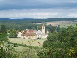
Boucle de Lancharre depuis la Chapelle-sous-Brancion (71)
- Thématique Randonnée
- Mis à jour le 31/08/2019
- Identifiant 576328
Sélectionner le fond de carte

PLAN IGN

PHOTOS AERIENNES

CARTES IGN MULTI-ECHELLES

TOP 25 IGN

CARTES DES PENTES

PARCELLES CADASTRALES

CARTES OACI

CARTES 1950 IGN

CARTE DE L’ETAT-MAJOR (1820-1866)

Open Street Map
Afficher les points d'intérêt à proximité
Hébergements
Informations
Lieux d'intérêts
Producteurs
Restauration
Services et Commerces
Autre
Echelle
|
durée / niveau
Rando pédestre
|
distance
13,8 km
type parcours
Boucle
|
|||||||||
|
Lieu de départ
71700 La Chapelle-sous-Brancion
|
accessibilite
|
|||||||||
|
prestations payantes
Non
|
type(s) de sol
Bitume
Terre |
|||||||||
Photos & vidéos (1)
|
description
Parcours facile, peu de dénivelé, très peu de routes, à travers cultures à découvert et ombrages de la forêt de Chapaize. Vallée du Grison- Vue sur le site de Brancion- Lavoirs- Visite libre (avec notice-guide) de la curieuse église clunisienne de Lancharre.
Hébergements à proximité

Saison conseillée
Eviter les périodes de forte humidité.
Marie-Claude
Note moyenne
Cartes associées
