
Aulnaie
- Thématique Lieux d'intérêt
- Mis à jour le 26/02/2019
Sélectionner le fond de carte

PLAN IGN

PHOTOS AERIENNES

CARTES IGN MULTI-ECHELLES

TOP 25 IGN

CARTES DES PENTES

PARCELLES CADASTRALES

CARTES OACI

CARTES 1950 IGN

CARTE DE L’ETAT-MAJOR (1820-1866)

Open Street Map
Afficher les points d'intérêt à proximité
Hébergements
Informations
Lieux d'intérêts
Producteurs
Restauration
Services et Commerces
Autre
Echelle
|
latitude
44.9861
|
longitude
5.97172
|
altitude
1139 m
|
|||
|
adresse
Chantelouve
|
accessibilite
|
||||
Photos & vidéos (1)
|
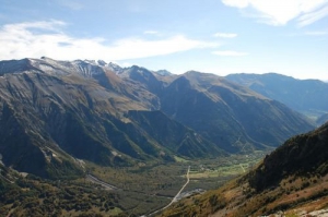
description
Depuis la piste, en regardant vers le col d'Ornon, au nord, vous pouvez observer, la plus vaste aulnaie (forêt d'aulnes blancs) de France, rayée de lacets. Il s'agit d'une aulnaie d'intérêt national inscrite dans le réseau européen des sites Natura 2000.
