
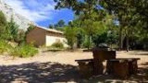
REFUGE CEZANNE
- Thématique Hébergements
- Mis à jour le 29/08/2015
Sélectionner le fond de carte

PLAN IGN

PHOTOS AERIENNES

CARTES IGN MULTI-ECHELLES

TOP 25 IGN

CARTES DES PENTES

PARCELLES CADASTRALES

CARTES OACI

CARTES 1950 IGN

CARTE DE L’ETAT-MAJOR (1820-1866)

Open Street Map
Afficher les points d'intérêt à proximité
Hébergements
Informations
Lieux d'intérêts
Producteurs
Restauration
Services et Commerces
Autre
Echelle
|
latitude
43.5291
|
longitude
5.56968
|
altitude
445 m
|
|||
|
adresse
13100 Saint-Antonin-sur-Bayon
|
accessibilite
|
||||
Photos & vidéos (1)
|
description
Construit par Jean Magnan et ses amis en 1954. Près du refuge, un amas de rochers avec une croix.
Sous cette croix il y avait la chapelle du hameau du Trou, dont il ne reste pas grand chose.
Sous cette croix il y avait la chapelle du hameau du Trou, dont il ne reste pas grand chose.
