
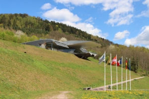
Mémorial de l'Alsace-Moselle
- Thématique Lieux d'intérêt
- Mis à jour le 23/09/2015
Sélectionner le fond de carte

PLAN IGN

PHOTOS AERIENNES

CARTES IGN MULTI-ECHELLES

TOP 25 IGN

CARTES DES PENTES

PARCELLES CADASTRALES

CARTES OACI

CARTES 1950 IGN

CARTE DE L’ETAT-MAJOR (1820-1866)

Open Street Map
Afficher les points d'intérêt à proximité
Hébergements
Informations
Lieux d'intérêts
Producteurs
Restauration
Services et Commerces
Autre
Echelle
|
latitude
48.4865
|
longitude
7.22183
|
altitude
312 m
|
|||
|
adresse
Mémorial Alsace-Moselle
67130 SCHIRMECK |
accessibilite
|
||||
|
services à proximité
Parking
Point d’eau potable
Toilettes publiques
|
|||||
Photos & vidéos (1)
|

Massif des Vosges Itinérance
Note moyenne
Parcours avec ce point d'intérêt
GR®5 - TRAVERSEE DU MASSIF DES VOSGES - ETAPE 9 SCHIRMECK LE HOHWALD
Historique, patrimoine
22.9 km
| par Massif des Vosges Itinérance |