
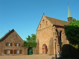
Chapelle d'Obersteigen
- Thématique Lieux d'intérêt
- Mis à jour le 24/09/2015
Sélectionner le fond de carte

PLAN IGN

PHOTOS AERIENNES

CARTES IGN MULTI-ECHELLES

TOP 25 IGN

CARTES DES PENTES

PARCELLES CADASTRALES

CARTES OACI

CARTES 1950 IGN

CARTE DE L’ETAT-MAJOR (1820-1866)

Open Street Map
Afficher les points d'intérêt à proximité
Hébergements
Informations
Lieux d'intérêts
Producteurs
Restauration
Services et Commerces
Autre
Echelle
|
latitude
48.6423
|
longitude
7.30614
|
altitude
463 m
|
|||
|
adresse
rue de la chapelle
67710 Wangenbourg-Engenthal |
accessibilite
|
||||
Photos & vidéos (1)
|
description
Ancienne chapelle conventuelle romano-gothique Notre-Dame de l'Assomption

Massif des Vosges Itinérance
Note moyenne
Parcours avec ce point d'intérêt
GR®53 - TRAVERSEE DU MASSIF DES VOSGES - ETAPE 6 SAVERNE WANGENBOURG
Historique, patrimoine
26.3 km
| par Massif des Vosges Itinérance |