
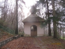
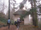
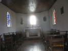
CHAPELLE DU LERCHENBERG à Rantzwiller
- Thématique Lieux d'intérêt
- Mis à jour le 07/12/2015
Sélectionner le fond de carte

PLAN IGN

PHOTOS AERIENNES

CARTES IGN MULTI-ECHELLES

TOP 25 IGN

CARTES DES PENTES

PARCELLES CADASTRALES

CARTES OACI

CARTES 1950 IGN

CARTE DE L’ETAT-MAJOR (1820-1866)

Open Street Map
Afficher les points d'intérêt à proximité
Hébergements
Informations
Lieux d'intérêts
Producteurs
Restauration
Services et Commerces
Autre
Echelle
|
latitude
47.6572
|
longitude
7.3756
|
altitude
314 m
|
|||
|
adresse
11 che altenberg
68510 Rantzwiller |
accessibilite
|
||||
notes, commentaires & photos (3)
Simone
le 24/04/2023 à 16:32
La chapelle a entièrement été rénovée par des habitants du village. La commune a réalisé l'aménagement du chemin d'accès. L'ensemble des travaux a duré près de 10 ans. La chapelle restaurée a été bénie en 2022.
ALC
le 11/12/2015 à 19:51
chapelle
|
ALC
le 11/12/2015 à 19:46
la chapelle
|
|
