
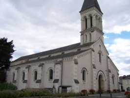
Eglise
- Thématique Lieux d'intérêt
- Mis à jour le 26/06/2017
Sélectionner le fond de carte

PLAN IGN

PHOTOS AERIENNES

CARTES IGN MULTI-ECHELLES

TOP 25 IGN

CARTES DES PENTES

PARCELLES CADASTRALES

CARTES OACI

CARTES 1950 IGN

CARTE DE L’ETAT-MAJOR (1820-1866)

Open Street Map
Afficher les points d'intérêt à proximité
Hébergements
Informations
Lieux d'intérêts
Producteurs
Restauration
Services et Commerces
Autre
Echelle
|
latitude
47.4079
|
longitude
-0.476199
|
altitude
25 m
|
|||
|
adresse
19 grande rue grande rue
49610 Juigné-sur-Loire |
accessibilite
|
||||
Photos & vidéos (1)
|
description
Dans sa partie la plus ancienne (XI et XIIIe siècles) l'église est classée par les Monuments Historiques. Le chœur témoigne du style angevin dit Plantagenêt (XIIIe siècle). Son clocher était dressé à l'origine à l'entrée du chœur. En 1853, il tombe, la nef et les bas-côtés sont alors refaits.
