
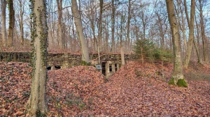
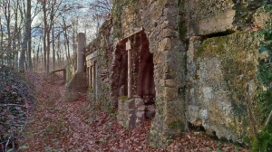
Redoute Sainte Catherine - Fort de Liouville
- Thématique Lieux d'intérêt
- Mis à jour le 30/03/2025
Sélectionner le fond de carte

PLAN IGN

PHOTOS AERIENNES

CARTES IGN MULTI-ECHELLES

TOP 25 IGN

CARTES DES PENTES

PARCELLES CADASTRALES

CARTES OACI

CARTES 1950 IGN

CARTE DE L’ETAT-MAJOR (1820-1866)

Open Street Map
Afficher les points d'intérêt à proximité
Hébergements
Informations
Lieux d'intérêts
Producteurs
Restauration
Services et Commerces
Autre
Echelle
|
latitude
48.8271
|
longitude
5.60324
|
altitude
360 m
|
|||
|
adresse
55200 SAINT-JULIEN-SOUS-LES-CÔTES
|
accessibilite
|
||||
Photos & vidéos (2)
|
|
description
Cette construction en bordure de la route stratégique n°3, fait partie du cercle de défense avancé du fort de type Séré de Rivières qui se trouve non loin de là sur la crête au dessus du village de Liouville.Nombreux vestiges de bombardement autour de l'abri.L'ouvrage n'est pas documenté. Son usage aurait pu être un casernement, un poste de contrôle, un poste de secours ... ??La zone en périphérie fut occupé par le 59 ieme Régiment d'Infanterie en 1918.
