
Le Huselberg
- Thématique Lieux d'intérêt
- Mis à jour le 07/04/2020
Sélectionner le fond de carte

PLAN IGN

PHOTOS AERIENNES

CARTES IGN MULTI-ECHELLES

TOP 25 IGN

CARTES DES PENTES

PARCELLES CADASTRALES

CARTES OACI

CARTES 1950 IGN

CARTE DE L’ETAT-MAJOR (1820-1866)

Open Street Map
Afficher les points d'intérêt à proximité
Hébergements
Informations
Lieux d'intérêts
Producteurs
Restauration
Services et Commerces
Autre
Echelle
|
latitude
47.8851
|
longitude
6.9766
|
altitude
706 m
|
|||
|
adresse
68470 Husseren-Wesserling
|
accessibilite
|
||||
|
Mots clés
Panorama, Sommet, Vue360°
|
|||||
Photos & vidéos (1)
|
description
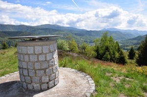
Dans la vallée de la Thur, le Huselberg est un des points culminants du circuit du Chauvelin. Il domine un ancien pâturage. Il offre un point de vue exceptionnel et panoramique, du lac de Kruth-Wildenstein aux Alpes de l'Oberland Bernois en passant par le plus haut sommet du massif des Vosges : le Grand Ballon (1424 m alt.). Une table d'orientation installée par le club vosgien de Saint-Amarin aide à découvrir et interpréter ce paysage.
Altidude du Huselberg
Le Huselberg culmine à 706 mètres au dessus du niveau de la mer.
