
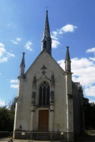
CHAPELLE SAINTE-ANNE.
- Thématique
- Mis à jour le 13/03/2025
Sélectionner le fond de carte

PLAN IGN

PHOTOS AERIENNES

CARTES IGN MULTI-ECHELLES

TOP 25 IGN

CARTES DES PENTES

PARCELLES CADASTRALES

CARTES OACI

CARTES 1950 IGN

CARTE DE L’ETAT-MAJOR (1820-1866)

Open Street Map
Afficher les points d'intérêt à proximité
Hébergements
Informations
Lieux d'intérêts
Producteurs
Restauration
Services et Commerces
Autre
Echelle
|
latitude
47.3845
|
longitude
-1.56096
|
altitude
35 m
|
|||
|
adresse
44390 CASSON
|
accessibilite
|
||||
Photos & vidéos (1)
|
description
A l'entrée Sud du bourg, près du château du Plessis, elle date de 1849 et fut construite avec les pierres de la première chapelle de Casson située il y a plus de 1000 ans. Classé monument historique par arrêté du 14 février 1989
Accueil des animaux ?
Animaux acceptés : non
Réseau e-SPRIT
Note moyenne