
Table d'orientation du Puy des Ferrières
- Thématique Lieux d'intérêt
- Mis à jour le 15/08/2025
Sélectionner le fond de carte

PLAN IGN

PHOTOS AERIENNES

CARTES IGN MULTI-ECHELLES

TOP 25 IGN

CARTES DES PENTES

PARCELLES CADASTRALES

CARTES OACI

CARTES 1950 IGN

CARTE DE L’ETAT-MAJOR (1820-1866)

Open Street Map
Afficher les points d'intérêt à proximité
Hébergements
Informations
Lieux d'intérêts
Producteurs
Restauration
Services et Commerces
Autre
Echelle
|
latitude
45.3562
|
longitude
1.71365
|
altitude
499 m
|
|||
|
adresse
Puy des Ferrières Le Puy des Ferrières
19700 SEILHAC |
accessibilite
|
||||
Photos & vidéos (1)
|
description
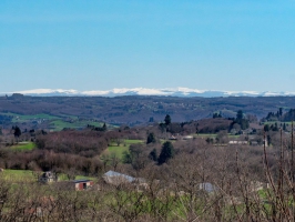
Aménagée en haut d'un monticule au Puy des Ferrières qui culmine à 543 mètres, la table d'orientation offre une vue à 180° sur la campagne, jusqu'au Puy de Sancy et au Puy Mary.
Contact
Téléphone filaire : 05 55 26 59 61
Site web (URL) : https://www.tulle-en-correze.com
Mél : tourisme@tulle-en-correze.com
Site web (URL) : https://www.tulle-en-correze.com
Mél : tourisme@tulle-en-correze.com
Typologie d'activités et de loisirs
Point de vue / Table d'orientation
Equipements
Parking autocar
Infos sur la visite
Conditions de visite : Visite libre